March 2023: Tax Parcel Data Sharing in New York State

Half of New York’s Counties now make parcel data available for free through Open Data efforts though barriers in specific governments still need to be overcome before statewide data is available

Not too long ago, I was communicating with a colleague about how some governments still, in 2023, continue to charge or license tax parcel data.  At first, somewhat amazing considering how far the Open Data movement has come over the past 10-15 years across the Empire State.  As recently as late 2022, information from the NYS GIS Program Office, which monitors the availability and sharing of tax parcel data statewide, shows that nearly 50 percent of NYS counties are making tax parcel data available for free through various means.  Great strides being made perhaps suggesting that one day the barriers prohibiting the sharing of parcel data across the entire will finally be nonexistent?   And that the gripes and complaints I was sharing in conversation with my colleague would go away.

Or maybe not.

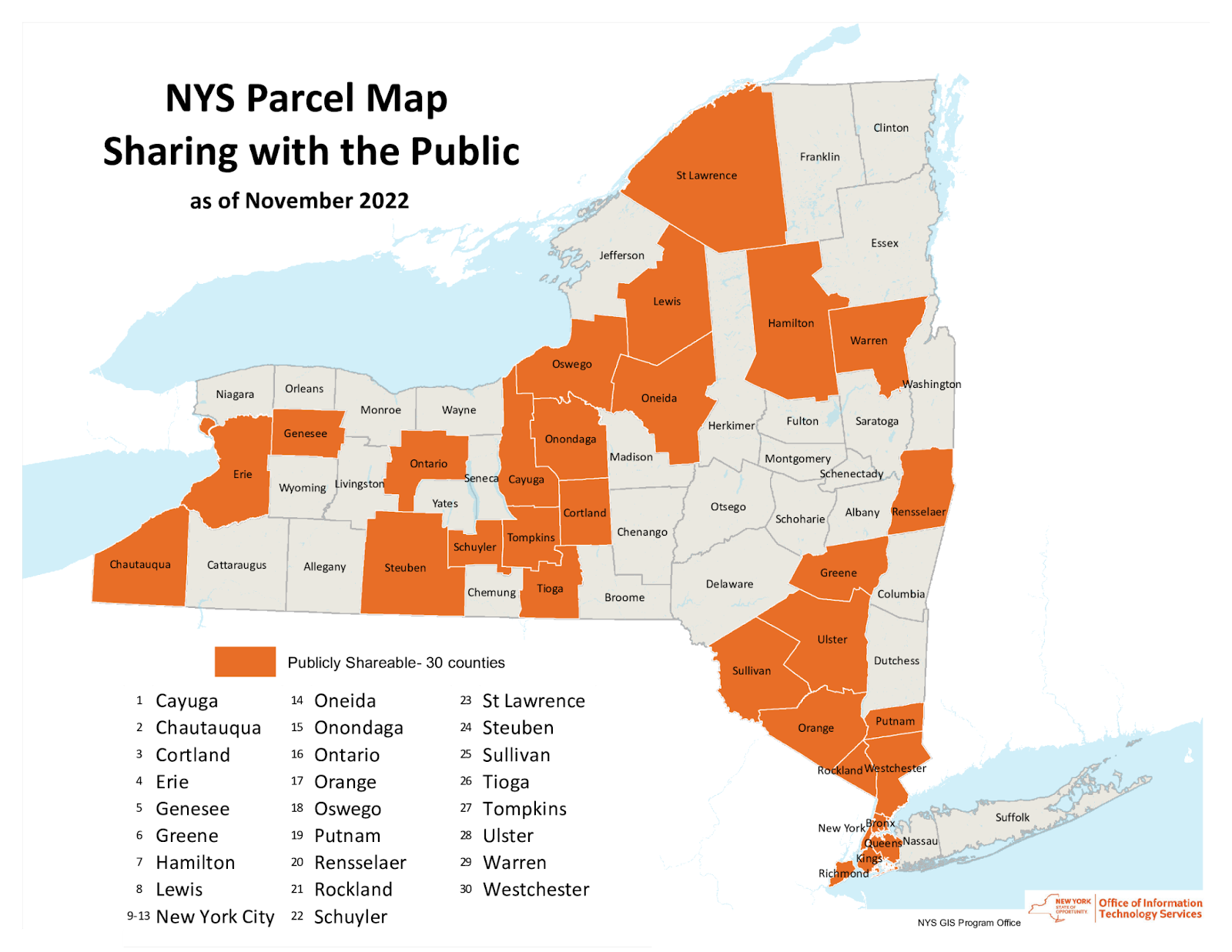
Since November 2022, this map has been updated and NYS GPO now notes that half of the statewide counties currently share tax parcel data

Issue Was Discussed Early On – What Happened?

In the early days of statewide GIS development (circa 1990s) the GIS community was fortunate to have Bob Freeman, former Executive Director of the New York State Commitee on Open Government (COOG) participating in the growth of the GIS movement.    Bob seemingly recognizing and witnessing the formation of a technology which would have a tremendous impact on government records and data.  Almost knowing that as part of the new technology, digital versions of data would become just as important or even more valuable than hardcopy format.  He was involved in statewide GIS conferences and contributed in many ways.    All said and done, he was a staunch advocate of making GIS data available – largely long before the “Open Data” concept was framed.

I was only able to find a few of his opinions searching the COOG archives and ultimately reached out to the current COOG Executive Director Shoshana Bewlay to both bring to her attention of governments still charging for tax parcel data as well as to see if she, or her staff, might be interested in revisiting the issue.  I heard back promptly from  Kristin O’Neill, Assistant Director who was kind enough to send me a link to all of the COOG opinions (7) which included “GIS”.  The links to all of the GIS-related opinions are below which can either be read through in its entirety or skimmed-over.   There is a lot here some of which is better interpreted by an attorney.  7507, 11230, 13575, 14366, 15058, 15695, 19246.  Looking back, I’m not sure why I thought the issue had gone further along in the legal system and had been resolved to a more definitive degree. But these few opinions suggest otherwise.  

More than once, COOG responded to the question/issue of an individual or organization questioning the basis of a government organization either selling or licensing tax parcel data.  And in general, each time, the COOG response – or opinion – was the same noting that electronic records (digital) records are no different than hardcopy records and should be made available at the cost of duplication.  (Keeping in mind original Freedom of Information Law (FOIL) costs of duplication were originally based on hardcopy records (i.e., for example 25-cents per page) and did not/does not have specific rates for digital data duplication.  Today, staff time, tapes, etc., can be included in the charge. However, since COOG opinions are advisory in nature only in context of FOIL, the early inquiries did not result in any formal legal challenge being launched on any level against any entity with regard to the selling of tax parcel data.   Suffolk County early on became involved in litigation on licensing/copyright issues (referenced in one of the opinions) which is still in place today.  But by the late 1990s, the selling of tax parcel data was in place and had become business as usual.  It seems the geospatial community is no further along in “the challenge” to the selling or licensing of tax parcel data than we were some thirty years ago.

Continue reading

Spatial Data Science Conference 2019

I had the opportunity to attend the 2019 Spatial Data Science Conference (SDSC) at Columbia University on October 16th.  Hosted by NYC-based Carto, the event was attended by over 500 people from government, nonprofits, industry and business, and academia.  The day-long conference was highlighted by a variety of presentations and lightning talks from data scientists and program managers representing organizations from around the world including Uber, Airbnb, Datarobot, Waze, Instacart, MIT, Sidewalk Labs, Two Sigma, and Facebook among others.  All of the presenters use Carto’s Software as a Service (SaaS) platform which provides GIS functionality, web mapping, and spatial data science tools.

Data Science

Founded in 2017, SDSC  brings together organizations who are pushing the boundaries of spatial data modelling – ranging from large enterprise, to cities and government, as well as thought leaders from academic institutions.  Shown through the use of geospatial applications and organizational project initiatives, there was no doubt the common denominator and focus of those attending:  Data. It was definitely worth the trip.  SDSC is similar, but a very different kind of a “geospatial conference” for those of us who have spent a career running in traditional government geospatial circles.  Attendees and presenters are largely a completely different make-up from those normally attending the annual New York State GIS conferences.  (Of the 500+ preconference registrants, nearly 55% were from the private sector).   The day’s event included high quality presentations on the latest in modelling techniques, data science and analytics, visualization practices, and new data streams.  This later issue an increasingly important and interesting one across the statewide geospatial community as the day’s conversation clearly illustrated both the growing number of online geospatial data sources  (for example, numerous references were made to U.S. Census Bureau American Community Survey) and related data access tools.  Speakers noted both the importance and benefits of open data portals though not without the caveat that it was not uncommon to have to clean and often normalize the data prior to using in applications.  Numerous references to popular sites such as GitHub, Leaflet, OpenStreetMap, and Elastic (which presented at the event) were made with regard to supporting the open source ecosystem.

Mudit Srivastav from Australia-based Origin Energy, presented on the use of spatial data to support the increase sales of residential roof top solar panels. Note the many types of data the company is using to better define growth areas.

Data for the Social Good

Another common theme throughout the day was the use of geospatial data for the social good.  Interesting to hear the point being made not only from nonprofits and academia, but from the private sector as well.  Way far away from the normal Albany GIS crowd, Stuart Lynn made a presentation focusing on how Two Sigma, an investment management firm located in New York City, provides spatial analysis support through the company’s Data Clinic program to nonprofits, academic institutions, and government organizations.  Their focus:  Enabling and promoting social impact through data driven predictive models while funding breakthrough research, education and a wide range of charities and foundations.    The image below identifies some of their recent projects.  Great stuff and I’m already planning on a more in-depth article with Stuart in the future.

Enabling Social Impact Organizations with Spatial Analysis Techniques

Stuart’s talk, as well as others during the day, made reference to the  The Data for Good movement which was a social media movement first started by DataKind to highlight how data science could be used to help address a range of humanitarian issues. DataKind is a collaborative network of organizations that work together with data scientists to leverage the science of data for social impact.  DataKind’s afternoon presentation “Spatial Data Science for Social Good:  Improving Access to Dignified Sanitation in Haiti” was excellent.  The video for this session and all of the day’s presentations are now available online at the Spatial Data Science Conference website.

Arguably, the demand for “data scientists” will increasingly intersect and expand in government geospatial programs in areas such as the health and human services, climate change, public safety, sustainability and resiliency,  and social and environmental justice to name only a few.   As the universe of geospatial data continues to expand and be integrated with both new artificial intelligence (AI) and machine reading technologies, as well as combined with the availability of more powerful GIS software, it is easy to see where the demand for data scientists focusing on locational and predictive analytics is headed.

I asked Javier de la Torre, Carto founder and SDSC organizer, what his impressions were of the day’s presentations and content.  He replied:

“First, moving the data discussion from WHERE to Why. Time to move to analyzing data using maps opposed to just seeing data in maps.  Second, the rise of the Spatial Data Scientist and/or where advance GIS is emerging as a new platform. And third, identifying the need for better data marketplaces which provides interactive solutions resulting in increased performance to users”

Links to the 2017 and 2018 presentations are also available on the SDSC website.