Location: Corporate Office in Melville, New York / 10 Other locations
Website: www.h2m.com
Employees: 372 in Melville / 110+ in satellite offices
Established: 1933
 H2M is a multi-disciplined professional consulting and design firm focusing in the fields of architecture, engineering, and environmental sciences. From treatment facilities to public safety buildings, land surveying and road reconstruction, and from site assessment to remediation, H2M has helped design and build throughout many communities across New York State since 1933.
Geospatial Support in Water Supply Systems
H2M has built its engineering practice around its service to water clients working directly with municipal water suppliers and private water utilities. The company’s work in this space has grown significantly over the past five years and is built on decades of combined municipal and private A/E experience. Recent work has focused on supporting public and private water systems to comply with new U.S. Environmental Protection Agency (EPA) Revisions to the Lead and Copper Rules which require an initial inventory by October 16, 2024. One of the rule’s requirements mandates the inventory must be made publicly available online for systems serving a population of more than 50,000 people.
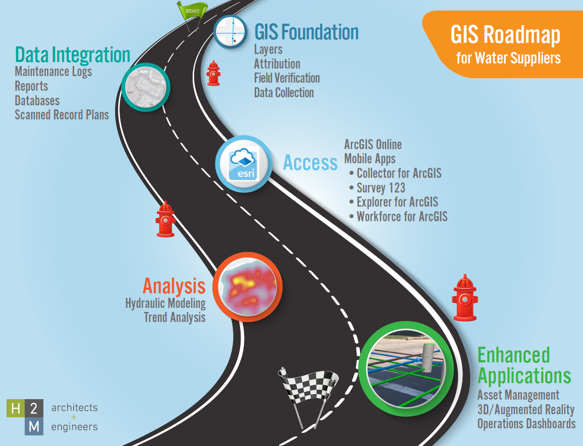
H2M’s primary water-related consulting includes, but is not limited to, comprehensive and cost effective water engineering, water quality analysis, distribution system mapping, water storage tank inspections, water quality testing services, lead service line (LSL) inventory, leak distribution analysis, main break mapping, hydraulic (pipe) modeling, and a full suite of online and mobile mapping applications utilizing industry leading GIS software solutions. Fully integrated GIS applications include access to maintenance logs, field notes, spur maps, tap cards, valve sketches, as-build drawings, and photos.
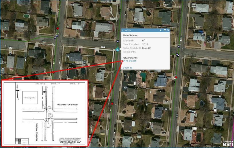
The scanning and indexing of historical hardcopy records of water system features adds great context and valuable information to new GIS-based applications
Complaint tracking, customer notification, and work order management functions are also supported by H2M as many infrastructure GIS systems are integrated with Enterprise Asset Management (EAM) programs such as Cartegraph, IBM Maximo, Cityworks, Tyler, AssetWorks, Infor, and Lucity. These systems often consume published GIS map services, ensuring dynamic connectivity for real-time data analysis and review.
In the realm of field data collection, mapping and viewing software is augmented by powerful mobile apps. ESRI’s suite of mobile software products includes Field Maps, Survey 123, Workforce, and QuickCapture. These mobile apps can be augmented by connecting to external GNSS devices for real-time coordinate correction and higher accuracy data collection.
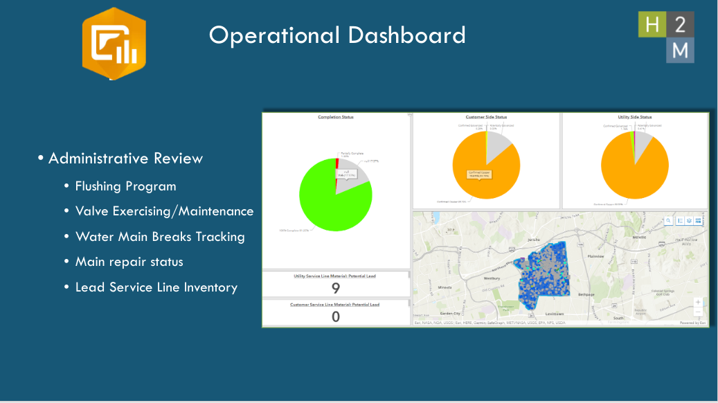
H2M’s work in the water system space includes the delivery of dashboards to which have become increasingly popular among administrators and decision makers providing a direct and “live” link to water system databases. Such dashboards access to pie charts, spreadsheets, photos, and mapping/viewing windows
Illustrative Projects:
Greenlawn Water District
H2M assisted the Greenlawn Water District in meeting new EPA lead service line inventory requirements by accurately geocoding each of their 12,017 service accounts and creating a data schema that complies with New York State Department of Health requirements. H2M reviewed multiple sources of information to determine service material including approximately 12,000 tap cards, dozens of hardcopy record replacement maps, and municipal records that include date of construction. Based on this information, H2M created an inspection map in ArcGIS Online which allows the District to determine areas with unknown service material and suspected lead which requires further investigation. H2M deployed Esri Field Maps as well as a Survey123 inspection form for the District to record their field inspections. This allows the District to easily document field inspections with notes and pictures, which are tied directly to the core GIS inventory data. Furthermore, H2M created multiple dashboards in ArcGIS Online that provide a dynamic snapshot of known and unknown service line material. This enables the District to quickly see the quantity of accounts that require further investigation and action, should replacement be required.
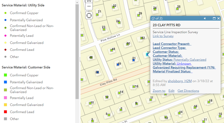
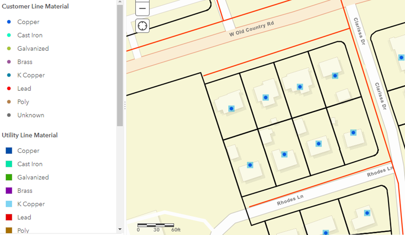
Online map viewers are easily configured to visually classify the types of water system materials owned by both the water district and by property owners
Village of Garden City Water Department
H2M was tasked to perform the Village-wide Lead Service Line (LSL) inventory and to develop a searchable, map-based data repository within its existing ArcGIS Online environment. As part of this work, H2M’s geospatial team reviewed several thousand individual records provided by the Village, including Excel spreadsheets, Building permits, plumbing permits, and nearly 1500 engineering plans. Information pertaining to water service material was transposed from the source materials to the GIS data. Source documents were also attached to the GIS data to facilitate simplified, map-based retrieval in the future. In addition to scanned documents, H2M incorporated information from engineer field observations, customer reports, and date of construction, as documented by the Nassau County assessor’s office.
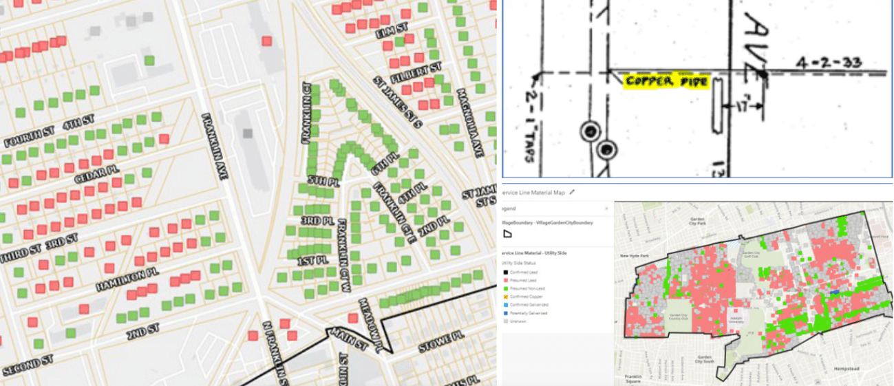
Every street-side and customer-side water service within the Village is mapped and catalogued by its documented material and status.
Veolia North America (formerly SUEZ Water New Jersey
Veolia owns, operates, and maintains a network of hundreds of miles of transmission and distribution infrastructure serving more than a million residents in numerous municipalities/institutions throughout the State. In advance of the proposed State of New Jersey lead service line regulations, Veolia launched a comprehensive lead service line replacement (LSLR) program in 2019. Veolia sought assistance from H2M architects + engineers (H2M) as Construction Administrator and Construction Observer to support the regulatory compliance goals and ensure detailed records of field activity, including digital mapping in a GIS framework.
The initial scope of the 2021 LSLR program was characterized by the performance of dig-and-determine for1,900 services and the replacement of approximately 1,200 (lead and non-lead) lines within the Veolia Hackensack Public Water System Identification (PWSID), which has since been expanded to 4,600 dig and determines and 2,500 replacements.
The most challenging portion of compliance for Veolia and H2M was in the identification, cataloging, mapping,and replacement of lead service lines in systems. Service line inventories must result in the categorization of services as either: LSL, brass with suspected leaded gooseneck requiring replacement, galvanized requiring replacement, or non-lead. Particularly vital to the success of this effort was the creation and maintenance of a set of standards intended to document compliance with the updated federal Lead and Copper Rule and ensure continuity of critical infrastructure data for future operations. To accomplish this, H2M utilized a novel, tablet-based data collection tool to document each crew’s daily activities and ensure immediate QA/QC access to the Veolia leadership team.
H2M’s work has ensured Veolia remains EPA compliant and ahead of the new requirements schedule.
Hicksville Water District
Since 1996, H2M has supported the Hicksville Water District and as part of this work, a service line material inventory was created for the District utilizing Geographic Information Systems (GIS) technology. Leveraging existing District data which exists in both hardcopy and digital format (tap cards, record replacement maps and date of construction records) and combining with field collected datasets, H2M continues to assist the District in meeting EPA Lead and Copper regulations. This also includes complying with public/private water system data standards established by New York State Department of Health.
ESRI’s ArcGIS Online provides an excellent framework to establish and serve easy-to-use map viewers that will allow residents to look up service material by either address or account number. H2M’s efforts support compliance with the regulation and increased transparency for the municipality.
Water distribution systems built before the 1950s often had distribution networks that were built with lead piping
Summary:
GIS industry software and practices including the ESRI and AutoCAD platforms.
Software flexibility and expertise in deploying need-based solutions ensures H2M’s clients have the information they need to continue to provide the highest level of service to our communities. A more detailed description of H2M’s capabilities and geospatial work in the water systems industry can be found in this presentation.
In addition to applying and creating solutions for the water systems sector, H2M’s geospatial team also provides client services in the following areas:
- BIM Integration
- Community Planning
- Data Conversion
- Digitization of Records
- Environmental Data Analysis
- Geodatabase Design
- Geospatial Analysis
- GPS Data Collection
- Hydraulic Modeling
- Mobile Application Development
- Municipal Asset Management
- Online Mapping
- Raster Analysis
- Special District Mapping
- Wetland Delineation
H2M is an ESRI Business Partner and was recognized with their ArcGIS Online Specialty designation for the continued deployment of successful online and mobile mapping solutions.
Contact:
Christopher M. Kobos, PMP
Director of GIS Services
H2M architects + engineers
538 Broad Hollow Road, 4th Floor East, Melville, NY 11747
tel 631.756.8000 x1731 | direct 631.392.5359 | mobile 516.946.9832 | fax 631.694.4122