Geospatial Business Spotlight: Woodard & Curran

Location:                      Rye Brook, New York (Other Locations Nationwide)

Website:                       Rye Brook & Corporate

Employees:                 30 Rye Brook Office / 1,200 Nationwide

Established:                1979

The Company

Woodard & Curran is a privately held, national integrated engineering, science, and operations company. It was founded in 1979 by  Frank Woodard and Al Curran with a mission to provide a safe and enjoyable place to work with opportunity, integrity, and commitment, and to attract talented people. Woodard & Curran experts are devoted to their work which is reflected in exemplary project and program results for both public and private clients. Through a multidisciplinary approach, Woodard & Curran strives to solve clients’ technical and business problems, routinely finding unique and cost effective solutions for their clients.

Geospatial Software and Technologies:

A registered ESRI Business Partner, Woodard and Curran’s geospatial team offers the following services:

  • Needs Assessment & Implementation Planning
  • ArcGIS Online (AGOL) Configuration & Management
  • ArcGIS Enterprise Planning & Implementation
  • Paper to Digital Conversion
  • Data Standards Development
  • Field Data Collection
  • Data Integration
  • Database Design & Administration
  • Map Production
  • Web GIS Development
  • Mobile Application Development
  • Asset Management Planning and Implementation
  • Computerized Maintenance Management System (CMMS) Integration
  • GIS and GPS Training

Geospatial Products and Services:

Woodard & Curran’s geographic information system (GIS) experts leverage the latest technologies to transform outdated data management processes into practical, efficient, and effective solutions for public and private clients. As a registered ESRI Business Partner, Woodard & Curran uses ArcGIS Online’s powerful platform to optimize spatial data through web maps and workflow specific applications for internal or public use. Woodard & Curran customized ESRI’s ArcGIS Online and Portal environments  provide clients with secure permission-based access for individual users to view, edit, or analyze data. Specific geospatial programs supported include:

ArcGIS Online Jumpstart Program

Focusing on the ArcGIS Online framework, Woodard & Curran provides customized, certified GIS professional assistance to organizations getting started with AGOL by offering:

    • Initial setup and configuration of an ArcGIS Online environment;
    • Prioritizing web maps and applications;
    • Instructions on setup, configuration, and use of web maps and applications;
    • Ongoing training for those responsible for managing AGOL environment

 GIS Enterprise Solutions

Woodard & Curran offers professional services for the full suite of ESRI ArcGIS products including ArcGIS Desktop, ArcGIS Enterprise, and ArcGIS Online along with extensions and add-ons. Such client services are offered on premise or remotely depending on the nature of the GIS professional services being provided. This work includes support for GIS needs assessments, data conversion & migration, and design & implementation of new GIS environments for clients just starting out with GIS. For clients with more mature GIS environments, Woodard & Curran professional staff also provide advanced GIS Strategy and Planning, System Integrations, or Advanced System Architecture and Design Services.

Field Data Collection Solutions

Woodard & Curran’s geospatial experts help clients identify, configure, and implement a variety of field and mobile data collection solutions.  Field data collection can include the inventory or field verification of assets using mobile technologies including smart phones, tablets, and Global Positioning System (GPS) devices. Depending on the needs of the project, information can be collected with varying degrees of location accuracy ranging from sub-meter to centimeter. Mobile data collection applications, such as ESRI Field Maps and Survey 123, and GPS solutions allow for accurate updates to be made in the field for real-time data management.

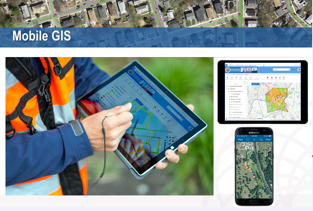
Mobile data collection is a “must-have” app for the engineering disciplines. Woodard & Curran designs and deploys a wide variety across many platforms.

Woodard & Curran’s GIS experts also offer drone services to access terrain or infrastructure that may be too vast or pose safety concerns with numerous FAA certified small unmanned aircraft system (sUAS) and drone pilots.  Drones produce high resolution orthoimages, elevation contours, three-dimensional and land use analysis, volume measurements, planimetric maps, and vertical or horizontal visual measurements.

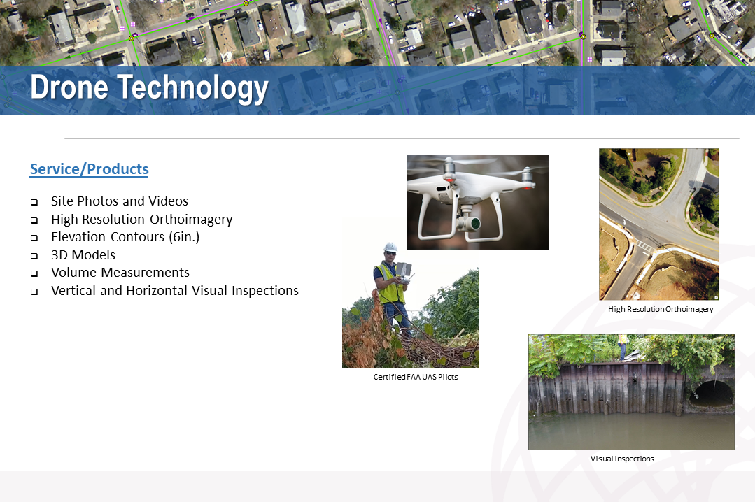
Woodard & Curran has FAA licensed UAS operators which help support many types of field data collection projects. Drones are increasingly being used to access sites which are either inaccessible or unsafe for field workers to get to.

Asset Management Technology

While asset management (AM) plans operate on a long-term vision, these plans rely on hundreds of daily dynamic inputs. And keeping track of these data points and life-cycle strategies requires a comprehensive AM technology program.

AM technology applications must be chosen carefully because they will store critical asset information, administer aspects of maintenance process and provide critical information to users when needed. These applications should fit both current and future needs, while providing the functionality necessary to maintain critical assets effectively. In supporting geospatial applications in this space, Woodard & Curran leverages business intelligence (BI) software, such as Microsoft PowerBI and ArcGIS Dashboards, to connect, integrate, analyze, and present business key performance indicator (KPI) data.

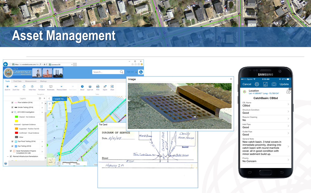
Woodard and Curran’s geospatial asset management strategy is integrated with organizational business programs such as Business Intelligence (BI) and Data Analytics and Enterprise Asset Management Systems (EAMS).

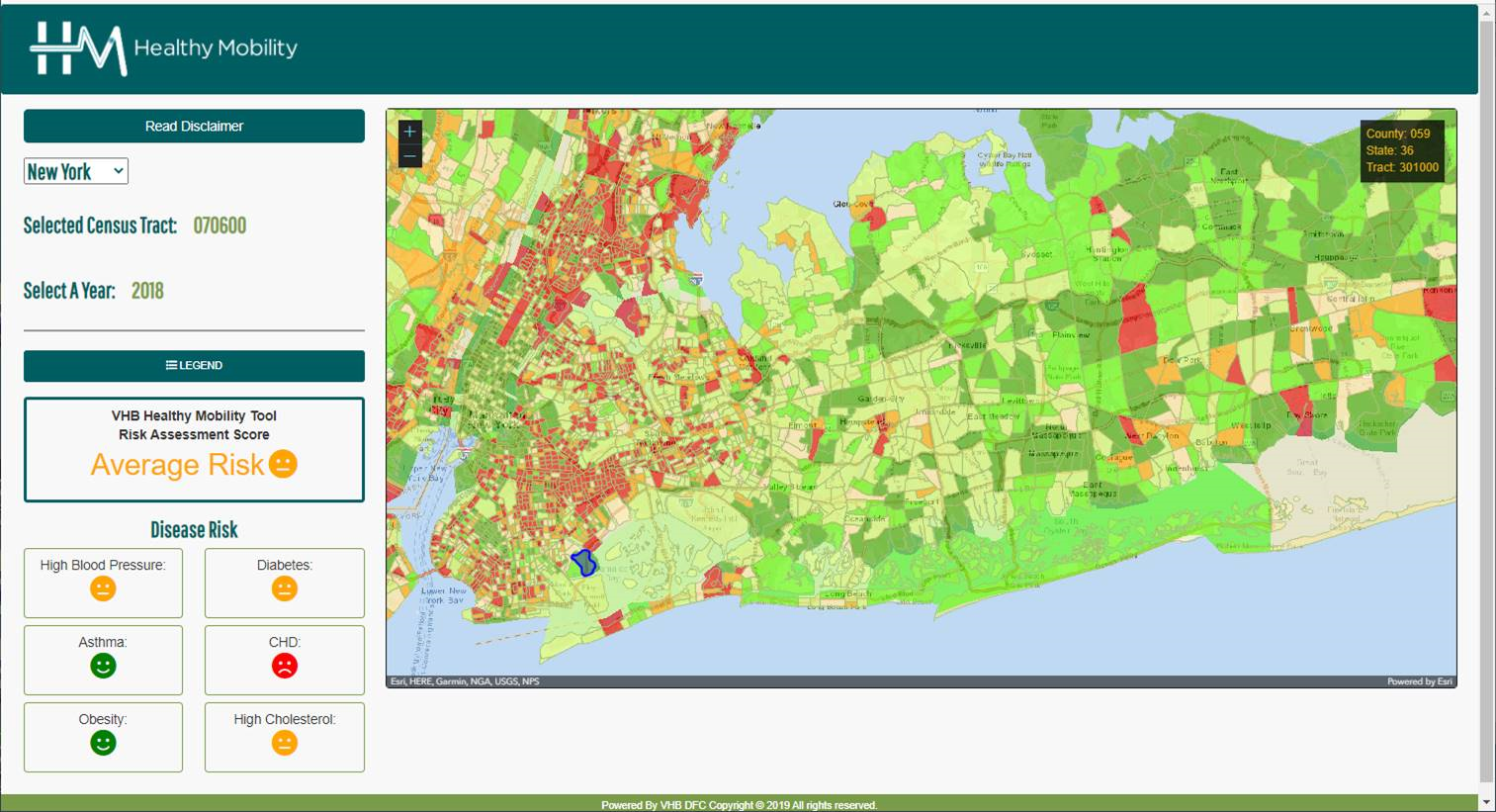
Testing Public Water Fountains for NYC Parks

New York City Department of Parks and Recreation (NYC Parks) retained Woodard & Curran to test for sources of lead in approximately 3,500 interior and exterior public drinking water fountains. While the initial proposal estimated eight weeks, the city wanted to fast-track the project with sampling beginning the first week of May 2019 and wrapping within five weeks. With the help of robust existing GIS data for the exterior fountains, Woodard & Curran’s field teams were able to meet this expedited timeline.

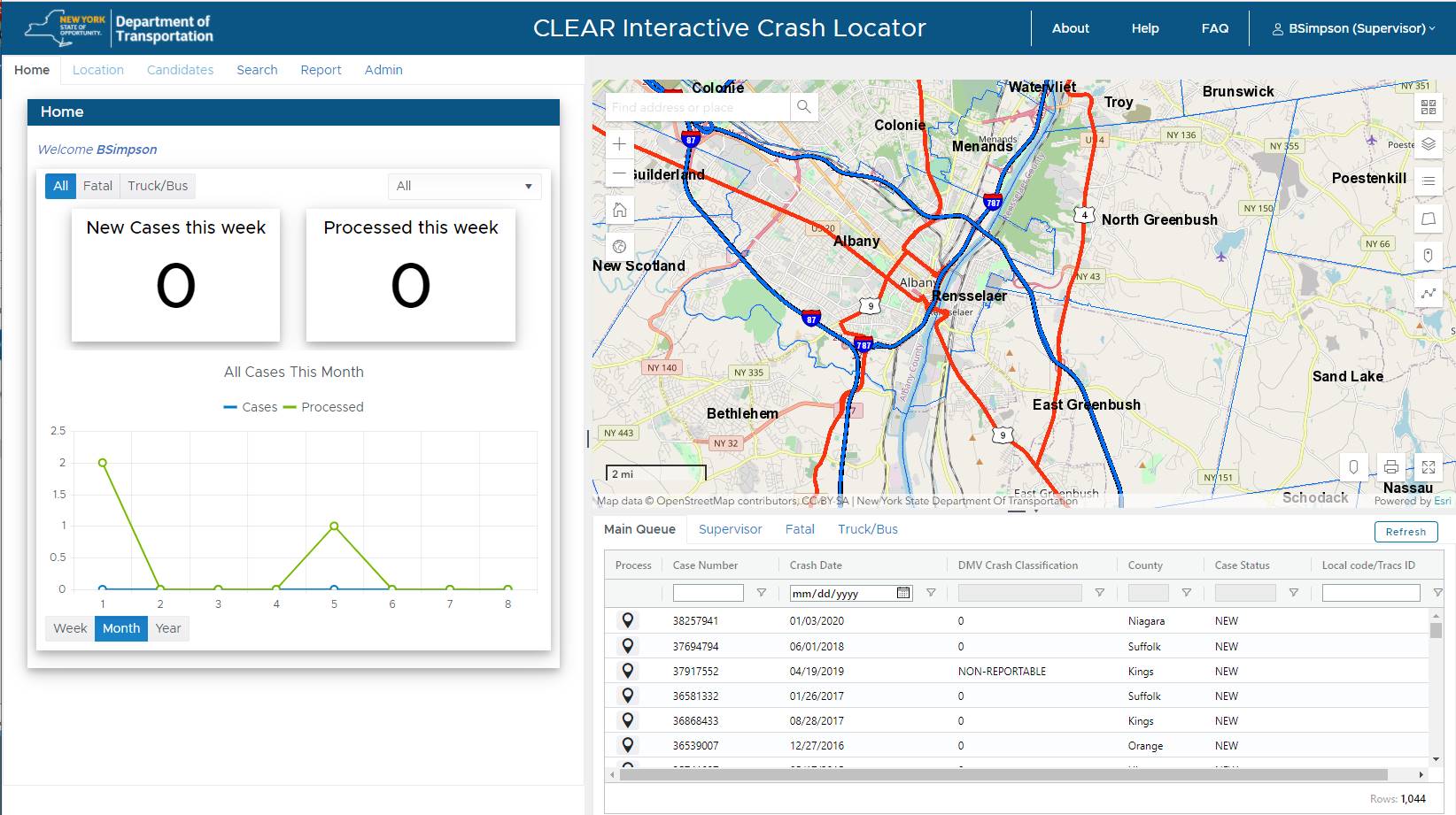
GIS data was analyzed to create groupings of fountain sites, organize workflow, and improve efficiency as six teams were deployed six days a week to reach nearly 900 public parks across the city’s five boroughs. Field staff were equipped with mobile devices to use GIS-compatible applications ArcGIS Collector and Survey 123 for real-time recording of sampling progress, asset information, and results reporting. The technology helped managed the need to cordon off each fountain for 8 to 18 hours, return to collect a sample after stagnation, and then a 30-second to one-minute flush sample. This also enabled field staff to build out GIS data for the approximately 500 interior fountains that were not previously listed in the client’s GIS. As the sampling progressed, the real-time collection of information on mobile devices fed into a public interactive map on the NYC Parks website.

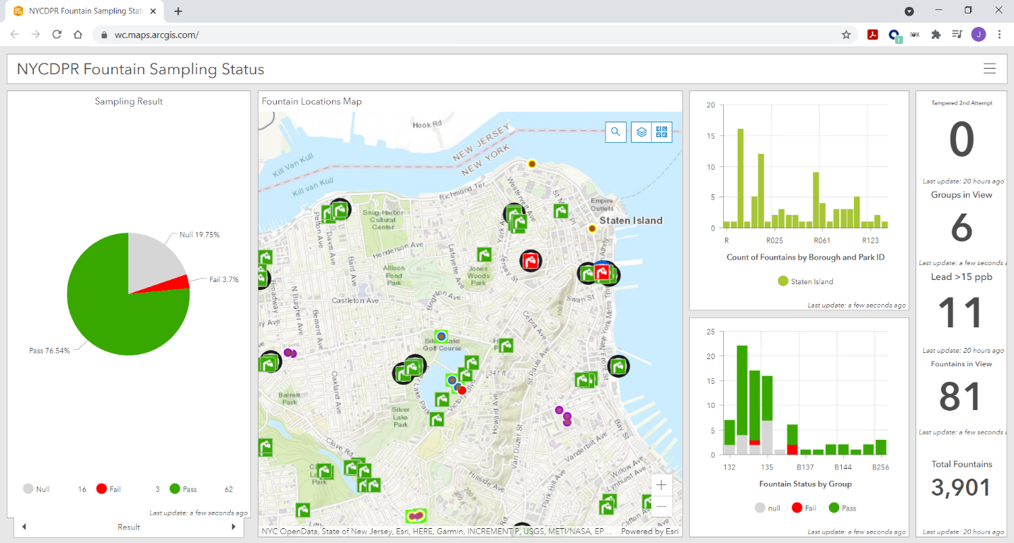
Woodard & Curran mapped and took water samples at over 3,500 water fountains across the five boroughs in New York City in 2019.  The effort added many new features which where previously not included in the drinking fountain inventory.

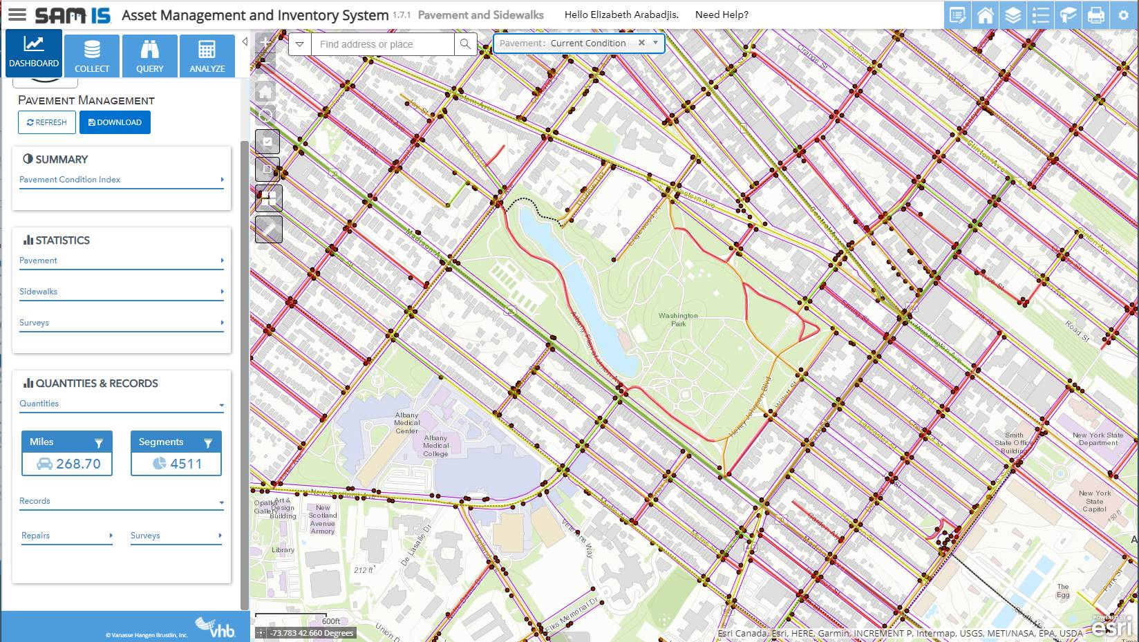
Workflow & Data Accessibility for Town of Cortlandt, New York

To improve efficiency across municipal departments that relied on information about physical assets, the town of Cortlandt sought to enhance its GIS program. Woodard & Curran worked with the town to identify specific ways to strengthen their GIS program, targeting data quality and work order management as areas of significant opportunity. By focusing on the quality and integrity of data, GIS experts helped develop a public web GIS platform. To further leverage the technology, a work order management system with mapping interface was developed for staff, which allows them to generate and close out work orders while still in the field. All data from the work order system is available to managers, enabling them to see emerging trends and improve planning efficiency.

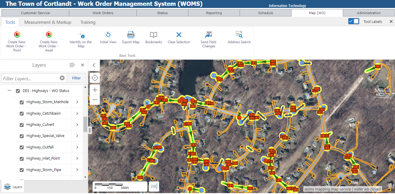
The Town of Cortlandt (NY) Work Order Management System (WOMS) provides town staff easy access to important municipal work orders (previous, current and pending) covering several operational programs and departments.

Contact:

Anthony Catalano, Senior Principal acatalano@woodardcurran.com
Jake Needle, GIS Program Manager jneedle@woodardcurran.com

Geospatial Business Spotlight: VHB

Location:                      Albany, New York (30+ locations along the East Coast)

Website:                       www.vhb.com  &  www.vhb.com/albany

Employees:                 180 New York State / 1,600 Nationwide

Established:                1979

The Company

VHB’s 1,600 professionals include engineers, scientists, planners, and designers partner with public and private clients in the transportation, real estate, institutional, and energy markets, as well as federal, state, and local governments. With locations along the East Coast, including five regionally in  Albany, Hauppauge, New York City, White Plains, and Newark, VHB is dedicated to improving mobility, enhancing communities, and balancing development and infrastructure needs with environmental stewardship.

VHB’s integrated services approach leverages a robust line of applied technologies the firm has developed through experience and cooperation with clients and partners. Whether it’s utilizing geospatial technology to pinpoint demographics to enhance decision making or keeping critical projects moving forward by utilizing Big Data, VHB’s team is dedicated to uncovering innovative solutions that benefit the communities they serve.

The following sections cover a few of these technologies, but for more information, please visit VHB’s Applied Technology website.

Geospatial Products and Services:

VHB celebrates a long history with the GIS community, integrating lessons learned and best practices to each new opportunity. As an Esri Business Partner for more than 20 years, and part of Esri’s Business Partner Advantage Program (BPAP) which provides access to Esri’s developers and technical staff, VHB is positioned to understand Esri technology at the highest levels and receive treatment for technical issues and targeted assistance. Additionally, VHB is certified as one of Esri’s ArcGIS Online Specialty partners, which symbolizes the company’s extensive experience in creatively implementing ArcGIS Online/Portal technology within any organization.

Services that are offered by VHB’s GIS consultants include:

Planning Services

  • GIS Strategic Planning
  • GIS Needs
  • Assessments GIS
  • Business Planning
  • ROI Studies
  • GIS Audits

Application Development

  • GIS Web Development
  • Mobile Application Development
  • Spatial Enablement
  • System Integration: BI, CRM, document management, permitting, asset management, etc

Support

  • On-Call Support
  • Technical Training
  • Maintenance of Data of Systems Created
  • Hosting of Web and Mobile Applications

System Design

  • Requirements Analysis
  • GIS System Architecture

Correlating GIS Mapping With Data for Healthy Communities

VHB’s innovative Healthy Mobility Model utilizes GIS mapping powered by ESRI to establish a baseline health risk assessment within a designated area by correlating census and published health data with land use, urban design, and mobility data. This assessment, or community health profile, eliminates intensive and time-consuming surveying while identifying and prioritizing improvements.

With the Healthy Mobility Model, municipalities can easily distinguish alternative scenarios and identify factors with the strongest relationships to building better health outcomes while tracking improvements over time. These quantitative results within a given profile help decision-makers think more holistically and support sustainable solutions that consider social, environmental, and economic impacts.

This VHB application combines six census track level disease risk variables to calculate an overall “Healthy Mobility” score. Based on the 2018 data in the application, this Long Island census tract had an overall “Average” risk.

Decoding Parcel Data to Understand Sites

VHB has been creating web-based parcel viewers for county and local government agencies within New York State for more than 15 years.  As internet technology and Esri’s solutions changed over the years, their experienced applied technologists have constantly evolved applications to remain state-of-the-art. The core components of all systems include a suite of GIS functionality and a robust user interface that gives users extensive tools for accessing and manipulating parcel data, including searching for parcel buffers, generating assessor’s lists, and accessing assessment information. Many sites also include custom functionality such as the creation of a parcel flyer, the calculation of wetland acreage, and the displaying of documents from other systems.

VHB has implemented numerous web-based parcel viewer applications for local and county governments within New York State, including:

VHB property/parcel viewers integrate a variety of spatial datasets from local, county and state data sources. The applications provide a range of functionality at the parcel level.

Leveraging Big Data and Traffic Analysis to Keep Projects Moving

Collecting traffic data is a critical piece of advancing transportation projects. Intersect, VHB’s latest technology-driven innovation, revolutionizes the way traffic volumes at urban, suburban, or rural intersections are quantified during typical and atypical circumstances. As a transportation planning tool, Intersect combines big data analytics and traditional traffic analysis to identify traffic data at intersections more efficiently than ever before, without the need for traditional manual or electronic counts.

By leveraging big data and traffic analysis through an innovative four-step process, Intersect keeps critical projects, and Departments of Transportation initiatives, moving forward.

Turning Data into Action

Since no municipality is exactly alike, collecting data on buildings can be an incredible challenge, especially when these results are needed quickly and efficiently.

VHB’s Cultural Information Resource System (CRIS) was developed for the New York State Historic Preservation Office (SHPO) as a web-based resource information system to catalogue and manage the agency’s huge range of programs and assets. CRIS records and manages data concerning the cultural resources within the State and gives both SHPO and their partner agencies a platform to submit, review and process wide varieties of historic preservation projects—effectively eliminating bottlenecks during a review process. CRIS also eliminates nearly all physical paperwork to help streamline record-keeping.

In the wake of Superstorm Sandy in 2015, VHB launched CRIS Trekker as a mobile-friendly enhancement to CRIS to help SHPO assess the condition of historic buildings and resources within the areas affected by the storm. CRIS Trekker captures real-time data in the field utilizing an easy-to-use interface that allows users to simply fill out a form, take a photo with their device, and submit digitally. The enhanced flexibility makes submitting, storing, analyzing, and managing incoming building surveys faster and more efficient.

In early 2020, VHB launched CRIS Trekker 2.0, a complete re-engineering of CRIS Trekker based on the latest Esri GIS platform. In the field, CRIS Trekker 2.0 has been critical in keeping technicians safe and allowing building surveys to continue.

The combination of CRIS and CRIS Trekker 2.0 has provided SHPO with an integrated digital platform to enable the continued review and processing of incoming projects without interruption during the COVID-19 pandemic.

Improving Mobility & Safety in Communities

VHB designed the enterprise-level Highway Crash Geocoding & Safety Management Systems to help state transportation agency clients improve mobility and communication within the communities they serve. This future-focused technology manages the safety of community streets and roadways, streamlines workflows and processes, and helps agencies (like those listed below) deploy responses with enhanced speed and accuracy.

For NYSDOT, VHB is developing a new, customized suite of applications collectively called the Crash Location and Engineering Analysis Repository (CLEAR) system. CLEAR provides a series of modules for geocoding, editing, and managing crash data while providing tools for conducting the six-step safety management process to improve roadway safety and reduce the number of crashes, injuries, and fatalities within the state.

The CLEAR internal facing password-protected application provides NYSDOT staff a suite of tools to analyze statewide passenger and truck vehicle accident location data. Similar to all of VHB browser-based geospatial tools, the application is built on top of ESRI ArcGIS Online technology.

Managing Assets for Streamlined Capital Planning

 VHB’s Smart Asset Management and Inventory System (SAM IS) helps clients keep track of their inventory of physical assets, inspections, and maintenance so that capital planning can proceed without a hitch. The system is built on Esri’s ArcGIS Online platform and designed it to be intuitive and scalable so that whatever the need, clients can track and manage assets without over-spending valuable capital. Since it is cloud-based, SAM IS offers broad accessibility to anyone within an organization with basic Internet access. SAM IS dashboards also readily provide the information needed to help make more informed decisions and deliver projects faster, safer, and more efficiently. Available nationwide, both the City of Albany, NY, and the County of Westchester, NY, currently subscribe to SAM IS.

The VHB SAMIS application provides a wide range of functionality to clients including access to mapped infrastructure features, statistics, dashboards, and an interface connection to mobile data collection efforts.

Contact:

Steve Anderson, GISP
Director, VHB Applied Technologies
sanderson@vhb.com

Editor acknowledges the contribution of Elizabeth Arabadjis in preparation of this article