Celebrating – and Visualizing – New York State Scenic Byways

Recent national designation highlights impressive Scenic Byways inventory across the Empire State

With little fanfare in January, the Federal Highway Administration, through the National Scenic Byways Program (NSBP), added the Palisades Parkway Scenic Byway to its list of New York State “national” designated Scenic Byways.  The Palisades designation – northern and southern most boundaries highlighted in the image below –  brings the Empire State’s National Scenic Byways total to four joining the Great Lakes Seaway Trail, Lakes to Locks Passage, and the Mohawk Towpath Byway.  These four combine for nearly 700 miles of nationally – designated scenic byways across the state.

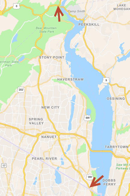
The new nationally designated Palisades Parkway Scenic Byway, part of the State’s Scenic Byways program, originates in the south at the New York/New Jersey boundary heading north approximately 26.5 miles to just west of the Bear Mountain Bridge.

The designation augments the established New York State Scenic Byways program which includes both the federal and state designated scenic byways.  Administered through NYS Department of Transportation, the State’s Scenic Byway program was created in Highway Law (HAY 349-aa-dd) in 1995 authorizing the Commissioner of the NYSDOT to establish the scenic byways program and to coordinate the activities of state agencies, local governments and not-for-profit organizations.  Prior to the establishment of the state Scenic Byway program, the NYS Department of Environmental Conservation had a scenic roads program under Article 49 of the Environmental Conservation Law.  Those roads, along with all state parkways (listed in the regulations of the Commissioner of the Office of Parks, Recreation and Historic Preservation pursuant to Section 13.03 of Parks, Recreation and Historic Preservation Law) were incorporated into the Scenic Byway program under HAY 349-dd (k) and (l).

HAY 349-bb defines a “Scenic Byway” as a transportation route and adjacent area of particular scenic, historic, recreational, cultural or archeological characteristics which is managed to protect such characteristics and to encourage economic development through tourism and recreation.  Today, the State’s program includes the four national and 26 state designations.  A list of all designations the program is available here which includes a link to a thumbnail graphic of each byway.

State Scenic Byways Map

The January designation gave me reason to revisit a favorite piece of cartography I’ve been eyeing and wanting to write about for quite some time.  It’s a map on the Scenic Byways web page which speaks to the art of a well and purposely designed hardcopy map.  Increasingly lost as part of our insatiable appetite for interactive online mapping as the primary “cartographic” end product. Substituting the web viewer for what once was the primary GIS desktop objective:  The map.

Descriptive information and an individual map of each byway is found on the Scenic Byways homepage.

The map was created by staff in the Landscape Architecture Bureau (LAB) in the Department of Transportation. According to Christine Colley, Senior Landscape Architect and Scenic Byway Coordinator, its original creator was Marcy Sammons – who now works for another state agency.  Map revisions – to update routes and add new routes not previously included in the original map – is now the responsibility of Alexandra von Bieberstein.  Both staff are landscape architects whose background clearly contributed to the “feel” and overall simplistic cartographic design of the map. Symbology – colors, fonts, labels and shields – are all appropriately selected.   The state boundary clearly defined with green/gray green underlying base map colors which accentuates the colors representing the statewide byways. Even the limited use of selected hydrologic features – providing more context to the map than anything – as well as the limited amount of place names adds to the visual appeal of the map.  All map components combined to perfectly convey the statewide scenic byways story.

Colley notes “The map is created using ArcMap (LAB currently using version 10.7.1  although the original map may have been created using an earlier different version) and then then exported into Adobe Illustrator for editing and providing more detailed graphic enhancements.”

In absence of online mapping applications, Colley also adds that Scenic Byways staff respond to “map a specific Scenic Byway or to key locations on the Scenic Byway.  Staff also assists the public – using Google Maps to create a route – in navigating through the state to enable travelers to” requests by sending the public Google Maps “routes” from their location to:

  • Avoid parkways (which are limited access – no trucks, trailers or RVs on the parkways)
  • Encounter the most scenic route
  • Encounter the most scenic byways

For a myriad of reasons, hardcopy maps will continue to be an important product of the geospatial profession and a very special skillset to maintain.  The utility and importance of the traditional map has even been noted in online geospatial blogs and media publications in recent months.  Just last month there was an article in USA Today entitled ““Move aside, Google Maps, Apple Maps and GPS:  Why people still love their paper maps

If you haven’t had a chance, download the map and take a look.  Pan around, zoom in to larger scales and take a spin around the state.

Enjoy the views.

Contact:

Christine Colley, RLA
Scenic Byway Coordinator
Senior Landscape Architect
New York State Department of Transportation
Office of the Environment
50 Wolf Rd, POD 4-1, Albany, NY  12232
518-485-9313 | christine.colley@dot.ny.gov
www.DOT.NY.gov

Geospatial Business Spotlight: VHB

Location:                      Albany, New York (30+ locations along the East Coast)

Website:                       www.vhb.com  &  www.vhb.com/albany

Employees:                 180 New York State / 1,600 Nationwide

Established:                1979

The Company

VHB’s 1,600 professionals include engineers, scientists, planners, and designers partner with public and private clients in the transportation, real estate, institutional, and energy markets, as well as federal, state, and local governments. With locations along the East Coast, including five regionally in  Albany, Hauppauge, New York City, White Plains, and Newark, VHB is dedicated to improving mobility, enhancing communities, and balancing development and infrastructure needs with environmental stewardship.

VHB’s integrated services approach leverages a robust line of applied technologies the firm has developed through experience and cooperation with clients and partners. Whether it’s utilizing geospatial technology to pinpoint demographics to enhance decision making or keeping critical projects moving forward by utilizing Big Data, VHB’s team is dedicated to uncovering innovative solutions that benefit the communities they serve.

The following sections cover a few of these technologies, but for more information, please visit VHB’s Applied Technology website.

Geospatial Products and Services:

VHB celebrates a long history with the GIS community, integrating lessons learned and best practices to each new opportunity. As an Esri Business Partner for more than 20 years, and part of Esri’s Business Partner Advantage Program (BPAP) which provides access to Esri’s developers and technical staff, VHB is positioned to understand Esri technology at the highest levels and receive treatment for technical issues and targeted assistance. Additionally, VHB is certified as one of Esri’s ArcGIS Online Specialty partners, which symbolizes the company’s extensive experience in creatively implementing ArcGIS Online/Portal technology within any organization.

Services that are offered by VHB’s GIS consultants include:

Planning Services

  • GIS Strategic Planning
  • GIS Needs
  • Assessments GIS
  • Business Planning
  • ROI Studies
  • GIS Audits

Application Development

  • GIS Web Development
  • Mobile Application Development
  • Spatial Enablement
  • System Integration: BI, CRM, document management, permitting, asset management, etc

Support

  • On-Call Support
  • Technical Training
  • Maintenance of Data of Systems Created
  • Hosting of Web and Mobile Applications

System Design

  • Requirements Analysis
  • GIS System Architecture

Correlating GIS Mapping With Data for Healthy Communities

VHB’s innovative Healthy Mobility Model utilizes GIS mapping powered by ESRI to establish a baseline health risk assessment within a designated area by correlating census and published health data with land use, urban design, and mobility data. This assessment, or community health profile, eliminates intensive and time-consuming surveying while identifying and prioritizing improvements.

With the Healthy Mobility Model, municipalities can easily distinguish alternative scenarios and identify factors with the strongest relationships to building better health outcomes while tracking improvements over time. These quantitative results within a given profile help decision-makers think more holistically and support sustainable solutions that consider social, environmental, and economic impacts.

This VHB application combines six census track level disease risk variables to calculate an overall “Healthy Mobility” score. Based on the 2018 data in the application, this Long Island census tract had an overall “Average” risk.

Decoding Parcel Data to Understand Sites

VHB has been creating web-based parcel viewers for county and local government agencies within New York State for more than 15 years.  As internet technology and Esri’s solutions changed over the years, their experienced applied technologists have constantly evolved applications to remain state-of-the-art. The core components of all systems include a suite of GIS functionality and a robust user interface that gives users extensive tools for accessing and manipulating parcel data, including searching for parcel buffers, generating assessor’s lists, and accessing assessment information. Many sites also include custom functionality such as the creation of a parcel flyer, the calculation of wetland acreage, and the displaying of documents from other systems.

VHB has implemented numerous web-based parcel viewer applications for local and county governments within New York State, including:

VHB property/parcel viewers integrate a variety of spatial datasets from local, county and state data sources. The applications provide a range of functionality at the parcel level.

Leveraging Big Data and Traffic Analysis to Keep Projects Moving

Collecting traffic data is a critical piece of advancing transportation projects. Intersect, VHB’s latest technology-driven innovation, revolutionizes the way traffic volumes at urban, suburban, or rural intersections are quantified during typical and atypical circumstances. As a transportation planning tool, Intersect combines big data analytics and traditional traffic analysis to identify traffic data at intersections more efficiently than ever before, without the need for traditional manual or electronic counts.

By leveraging big data and traffic analysis through an innovative four-step process, Intersect keeps critical projects, and Departments of Transportation initiatives, moving forward.

Turning Data into Action

Since no municipality is exactly alike, collecting data on buildings can be an incredible challenge, especially when these results are needed quickly and efficiently.

VHB’s Cultural Information Resource System (CRIS) was developed for the New York State Historic Preservation Office (SHPO) as a web-based resource information system to catalogue and manage the agency’s huge range of programs and assets. CRIS records and manages data concerning the cultural resources within the State and gives both SHPO and their partner agencies a platform to submit, review and process wide varieties of historic preservation projects—effectively eliminating bottlenecks during a review process. CRIS also eliminates nearly all physical paperwork to help streamline record-keeping.

In the wake of Superstorm Sandy in 2015, VHB launched CRIS Trekker as a mobile-friendly enhancement to CRIS to help SHPO assess the condition of historic buildings and resources within the areas affected by the storm. CRIS Trekker captures real-time data in the field utilizing an easy-to-use interface that allows users to simply fill out a form, take a photo with their device, and submit digitally. The enhanced flexibility makes submitting, storing, analyzing, and managing incoming building surveys faster and more efficient.

In early 2020, VHB launched CRIS Trekker 2.0, a complete re-engineering of CRIS Trekker based on the latest Esri GIS platform. In the field, CRIS Trekker 2.0 has been critical in keeping technicians safe and allowing building surveys to continue.

The combination of CRIS and CRIS Trekker 2.0 has provided SHPO with an integrated digital platform to enable the continued review and processing of incoming projects without interruption during the COVID-19 pandemic.

Improving Mobility & Safety in Communities

VHB designed the enterprise-level Highway Crash Geocoding & Safety Management Systems to help state transportation agency clients improve mobility and communication within the communities they serve. This future-focused technology manages the safety of community streets and roadways, streamlines workflows and processes, and helps agencies (like those listed below) deploy responses with enhanced speed and accuracy.

For NYSDOT, VHB is developing a new, customized suite of applications collectively called the Crash Location and Engineering Analysis Repository (CLEAR) system. CLEAR provides a series of modules for geocoding, editing, and managing crash data while providing tools for conducting the six-step safety management process to improve roadway safety and reduce the number of crashes, injuries, and fatalities within the state.

The CLEAR internal facing password-protected application provides NYSDOT staff a suite of tools to analyze statewide passenger and truck vehicle accident location data. Similar to all of VHB browser-based geospatial tools, the application is built on top of ESRI ArcGIS Online technology.

Managing Assets for Streamlined Capital Planning

 VHB’s Smart Asset Management and Inventory System (SAM IS) helps clients keep track of their inventory of physical assets, inspections, and maintenance so that capital planning can proceed without a hitch. The system is built on Esri’s ArcGIS Online platform and designed it to be intuitive and scalable so that whatever the need, clients can track and manage assets without over-spending valuable capital. Since it is cloud-based, SAM IS offers broad accessibility to anyone within an organization with basic Internet access. SAM IS dashboards also readily provide the information needed to help make more informed decisions and deliver projects faster, safer, and more efficiently. Available nationwide, both the City of Albany, NY, and the County of Westchester, NY, currently subscribe to SAM IS.

The VHB SAMIS application provides a wide range of functionality to clients including access to mapped infrastructure features, statistics, dashboards, and an interface connection to mobile data collection efforts.

Contact:

Steve Anderson, GISP
Director, VHB Applied Technologies
sanderson@vhb.com

Editor acknowledges the contribution of Elizabeth Arabadjis in preparation of this article