10+ Questions: Eileen Allen

Eileen Allen is a familiar and respected face across the New York State GIS landscape.  First a foremost an instructor at SUNY Plattsburgh, she has instructed and mentored hundreds of students who are now part of the statewide geospatial fabric.  And in her spare time she has participated and contributed to numerous statewide GIS advisory committees over the past 20 years.  Always upbeat and a pleasure to work with, she is most certainly a first ballot lock for the GIS wing at the Hall of Fame in Cooperstown.  

eSpatiallyNewYork:  How long have you been at SUNY Plattsburgh?

Allen:  I was an undergraduate student at Plattsburgh State from 1973-1977.  In August 1984, I was hired to help finish a remote sensing research grant mapping historical beaver locations in the Adirondacks.  I’ve been here ever since.

eSpatiallyNewYork:  Where are you originally from and tell us about your journey that led to Plattsburgh.

Allen:  Both my husband and I grew up in Plattsburgh.  Fortunately there were state and federal programs to help me get a college education.  After college at SUNY Plattsburgh, I went to McGill and worked on a Master’s in physical geography.  Everything seemed to go wrong with my advisor and the research.  It was hard but necessary to leave there.   Fortunately, I could use my McGill credits and finish a Master’s program in Natural Resources at SUNY Plattsburgh while I worked on research projects.  I thought about getting my PhD but I just didn’t end up going in that direction.   Besides, I liked the research projects I was working on too much!

eSpatiallyNewYork:  You’ve been associated with the GIS program at Plattsburgh since its origin.  How did it get started?  Who was involved?

Allen:  My involvement with teaching GIS developed out of research projects and the need to train student workers. Dr. Richard Lamb was instrumental in developing the GIS courses and a minor in addition to his planning courses and practice.  He started the GIS course in the late-1990s and by the early-2000s we would take turns teaching the Introduction to GIS class.  I took over all the GIS classes when he retired and the Remote Sensing courses when Dr. Donald Bogucki retired.

But there is more, because so many chance occurrences determine our path.  Also, it has been noted that many more women are in GIS than in other natural sciences.  When taking college classes, I was often one of a very few or the only female.  Many people think that because GIS is so collaborative, women often gravitate towards it.  This is certainly true for me.

As an undergraduate, I was interested in many things but was unsure what I would major in and tried out several paths.  I needed a Social Science course and Physical Geography was on the list, so I took it.  Drs. Donald Bogucki (Geography) and Gerhard Gruendling (Biology) were working on a pilot project mapping wetlands and demonstrated this in their classes.  The grant was to investigate the use of remote sensing to estimate the impact of regulating the Richelieu River (the outflow of Lake Champlain, NY-VT) because of flooding concerns in Quebec.  Dr. Bogucki showed some color infrared imagery of wetlands in Physical Geography class and I was totally flabbergasted!  I absolutely had to be involved with the project!  It took several days for me to get the courage up to ask if I could be part of the research.  It so happened that they needed someone to use a transit to establish ground control.  I had been working with my father, a land surveyor, for many years and was enlisted by Dr. Bogucki to help set out targets and map them.

In the early 1970’s, it was very unusual for an ecologist and a geomorphologist to work together.  That was part of the attraction, though, where many of my interests could be combined. By chance, at about the same time, the Environmental Science Program was started at SUNY Plattsburgh and I had found my academic home.  I continued to be part of the project mapping Lake Champlain wetlands using custom flown 70-mm imagery until my graduation.
Continue reading

2018 Westchester GIS User Group Meeting

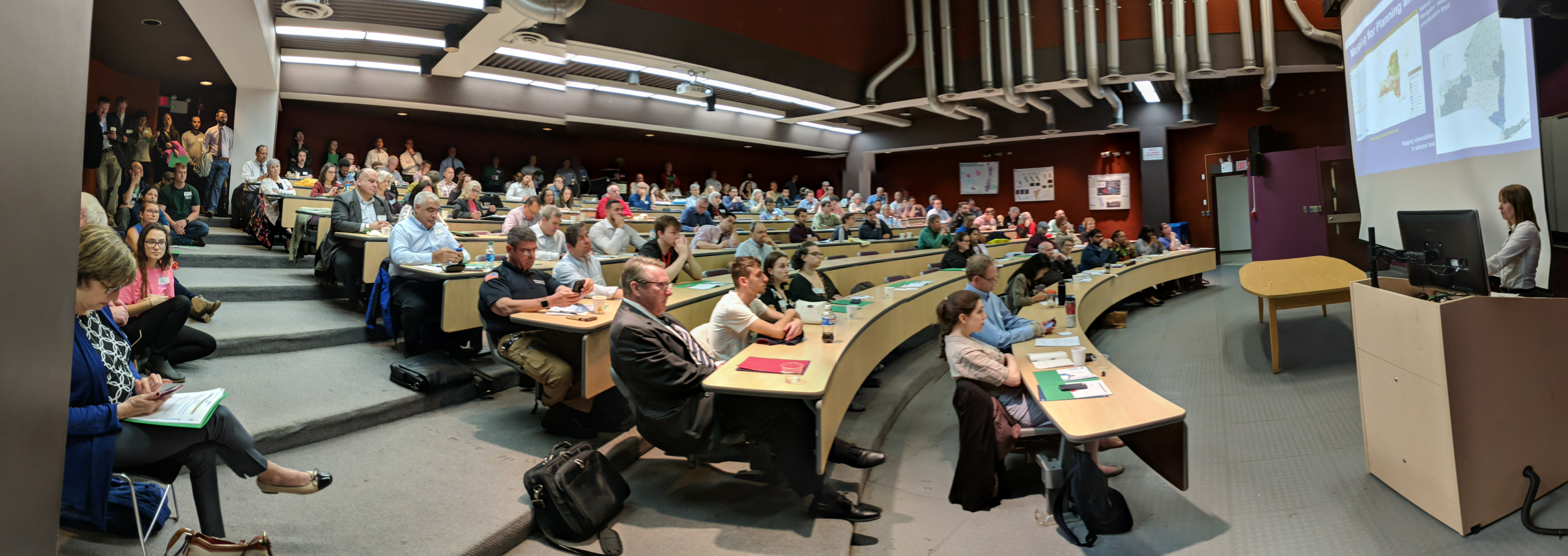
Westchester County GIS has been fortunate to build a broad and diverse community of GIS users and followers over the past two plus decades which is embodied at the our annual GIS User Group Meeting each May.  Similar to many first generation GIS government programs which were created in the late 1980s/early 1990s, most of the first decade worth of geospatial programs and applications Westchester County GIS developed were government focused.  But as geospatial technology grew at warp speed in industry and business and combining the development and availability of a high accuracy countywide Westchester County digital base map,  the visibility of the program quickly expanded.  Interest from public safety, nonprofit, academic and civic groups soon followed.   And not to minimize the importance of the continued political support the program has maintained over the past two decades at both the county and municipal level.   Illustrative of this year’s May 17th meeting held at Purchase College, nearly 170 representatives from  government, industry and business, utilities, academia, nonprofits,  community groups, and the military convened for the sharing of presentations, geospatial solutions, and best practices to move the countywide and regional geospatial agenda forward.

2018 Agenda

In years past there had always been an effort to keep the presentations and agenda diverse – a little bit of everything.   While this has generally served us well over the years, this was the first year we had a specific theme:  GIS for Resiliency and Sustainability.   This was in response to recent work our GIS program had completed in context of investigating potential impacts of projected sea level rise on county-owned assets as well as administrative changes in the Westchester County Executive  office as a result of the November 2017 elections.  In the process of bringing these two issues together and including the Office of Sustainability at Purchase College, we were able to add Westchester County Executive George Latimer and Purchase College President Thomas Schwarz to our agenda.  Both mentioned and acknowledged the importance and relevance of technology and geospatial in supporting the regional sustainability agenda.

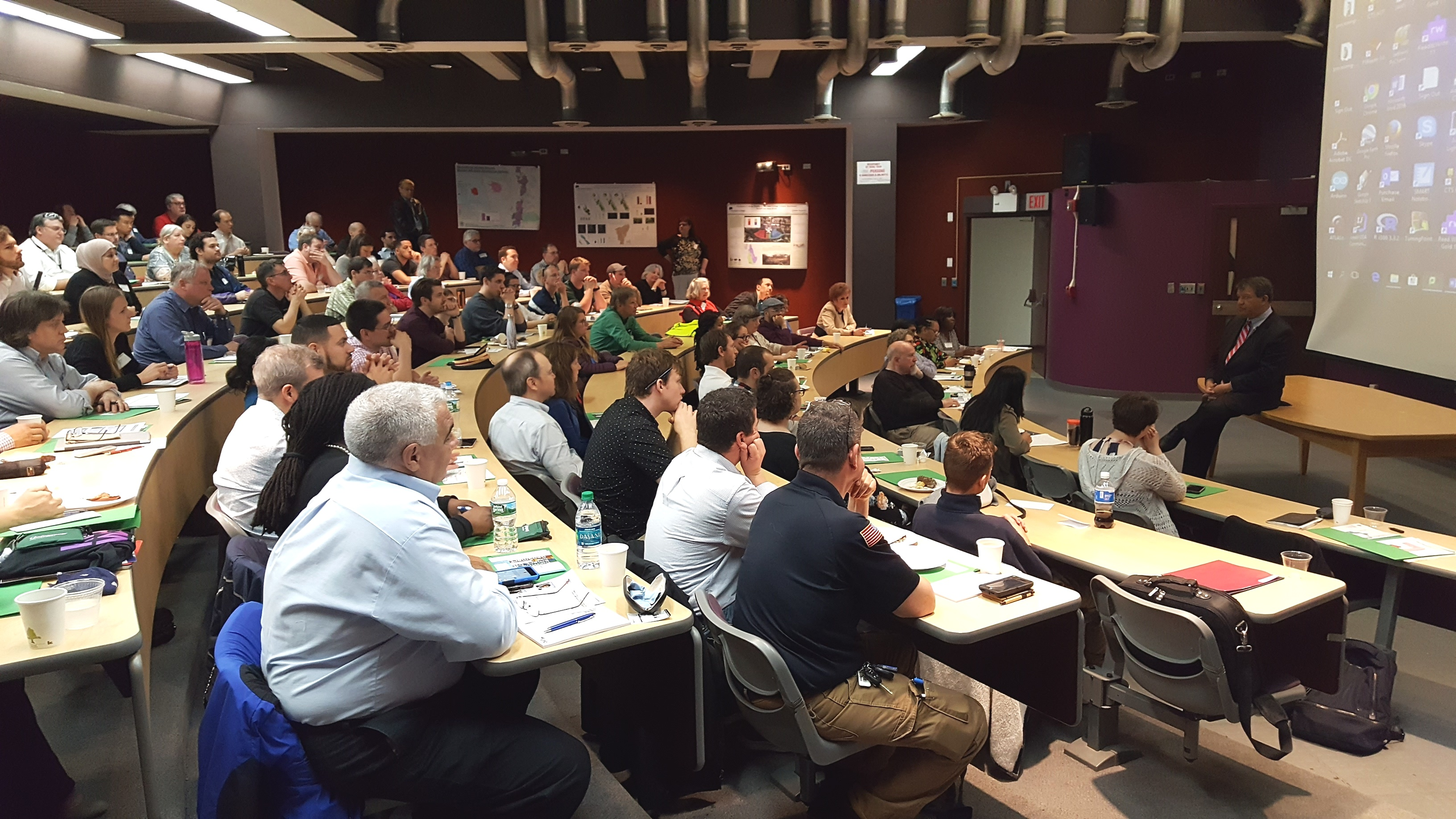
Westchester County Executive George Latimer talking with 2018 User Group meeting attendees. He made reference to the use of geospatial technologies in confronting Climate Change issues.

2018 Speakers

Working with the theme of GIS for Resiliency and Sustainability, we were able to include two well recognized state government speakers in Mark Lowery, Climate Change Analyst with New York State Department of Environmental Conservation, and Amanda Stevens, Project Manager with New York State Energy Research and Development Authority (NYSERDA) Environmental Research Program.  With the County’s work in this space increasingly including nonprofit groups, representatives from both  Abundant Efficiency and the Westchester Community Foundation were also on the agenda.  In the mix were talks by SUEZ North American (water utility) and BetaNYC – an open data advocacy organization based in New York Ctiy.   Additionally, we continued to feature our ongoing relationship with the U.S. Military Academy at West Point with a noon presentation by Lieutenant Colonel Jared Ware.  Our afternoon session of Lightning Talks and panel discussion featured Sustainable Westchester and representatives from five local governments.

In the morning session, Amanda Stevens provides an overview on NYSERDA’s work and research efforts in the area of climate change – which includes programs in the Lower Hudson River region

Bringing it Together

Admittedly there is always a little luck in hosting conferences such as this and it only takes a day of bad weather for attendance to bottom out (been there).  Of course, nothing beats an agenda based on current and cutting-edge geospatial topics backed with recognized speakers, but there are a couple other factors worth noting that seem to help make all of this work for us, including the following:

All Things Local:    For all the benefits and advantages of the larger shows, localizing the day’s content and message for local/regional like-minded individuals goes a long way.  Geospatial business needs and problems – and often the solutions – are conceptually very similar.  Familiar faces with familiar issues.  The organic approach.

Affordability:   Offering such events at a discount, like free as in our model, makes the event more attractive to more people.   However,  if its free, it is easy to not show.  Nothing paid nothing lost. And we have the historical numbers to show as such.  Over the past six-seven years we’ve seen a 25%-30% no show rate from the actual number of pre-conference registration numbers.    That said, we’ve learned to factor this variable in the printing of conference materials and sizing break refreshments and lunch.  We’ve also learned over the years that other groups and professional societies we’ve tried to partner with in hosting the show may be hesitant to collaborate because they (other organizations) do not want to send a message to their memberships that meetings, and certainly ones that offer Professional Development Units (PDU), are available for free. The bottom line for us is that we continue to make the show free based on vendor fees and affordable food services from the venue location.  And besides, there is no capacity to collect money online and/or to deal with bank accounts.  What little money management needs we have are handled graciously through the college.  Getting pass the bouncer at the door for free works for us.

Vendor Interaction:  I can’t say enough about how important this is.  We put a lot effort into making sure our sponsors have ample time for interaction with the attendees. Information gathered by attendees in the exhibitor area only adds to the overall value of their day.  Food and refreshments are close by so everything (and everybody) is in reaching distance of the vendors.  We also have vendor “Vendor Bingo Card” game that encourages attendees to visit each vendor table to qualify for a prize drawing.  Pretty nice incentive as this year the prize was a vendor donated iPad.   All sponsoring vendors are entitled to 5-minute “Vendor Spotlight” presentation over the course of the day.  Without vendor support the day doesn’t happen so we make it worth their while.


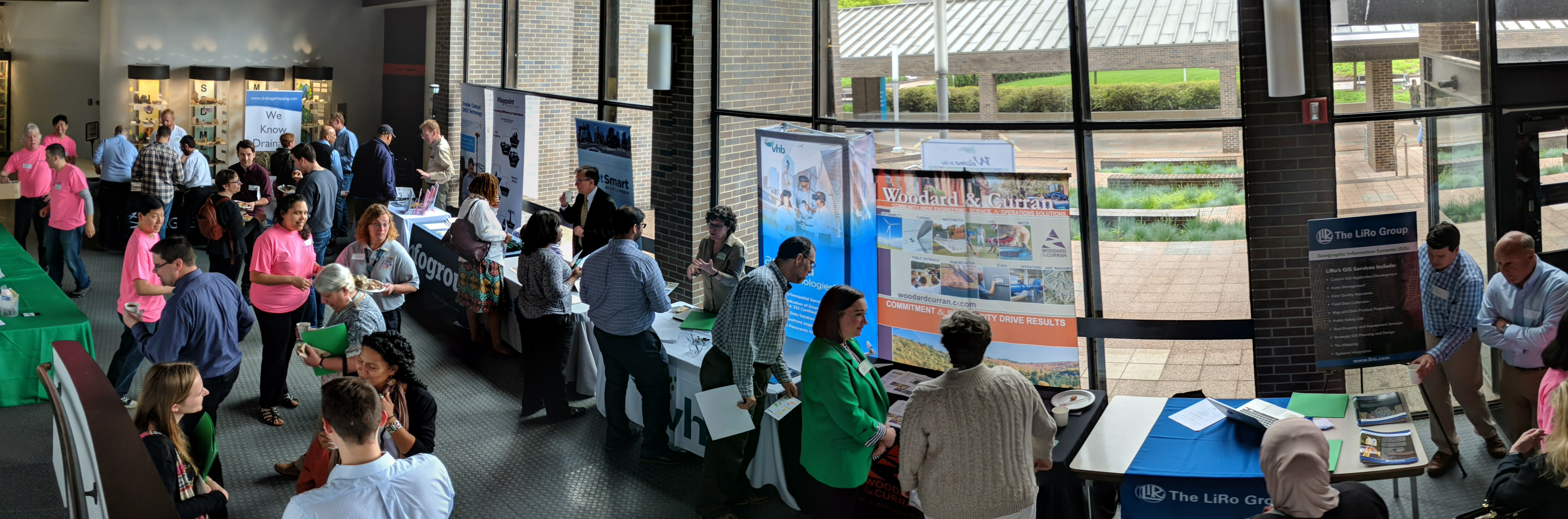
Everything is nearby at the Westchester GIS User Group Meeting. Vendors, refreshments, and the main auditorium are all intertwined and close. Making the experience interactive and personal on many levels. It’s a win-win for everyone in attendance. Who are those folks in pink?

The Venue:   For the past seven years, Purchase College has graciously made their facilities available to us to host the show.  Prior to that we bounced around the County at other locations, but given our relationship with the faculty in the Environmental Studies Program this became a logical spot. Centrally located in mid-Westchester.  Easy access.

A naturally lighted vendor area, albeit small, adds to the personal “feel” of the show.  One of the main reasons we originally went to Purchase during the third week in May was that the Student Union cafeteria was still open we could make lunch “on your own”.  Avoiding all the overhead and cost of providing lunch.  We’ve since been able to work with campus caterers to provide us with an affordable lunch menu which is vendor sponsored.   This “grab lunch and go” format enables users to eat where and how they want –  attending special lunch time presentations, continued discussions with vendors, or simply going outside to eat on the campus plaza.  The entire agenda is plenary format held in a cathedral style 150-seat auditorium.    We once tried a concurrent sessions format but it just didn’t work and feel right so we went back to the basics.  Post-meeting training sessions have proven to be hit or miss.  Just seems that just come 3PM after a long day of presentations, networking, and interacting with vendors, most folks are running to the exits.  Or the no-host reception down the street.

One of the ironies – and downsides – of having the show on a college campus in mid-to-late May is that spring semester is already over and students have fled campus, though  there is normally a handful attending looking for summer or full-time work and passing out resumes.    But we clearly do not have the college student attendance that is seen at comparable conferences such as GIS-SIG.

Engage the Professions:  We make a significant outreach to the “aligned” professions including engineering, public works, surveying, police and fire departments, government administrators, the planning community and increasingly nonprofits.  I wish there was an easier entry point into the 41 school districts here in Westchester County – and particularly their uber large budget bus transportation systems – but we’ve never been able to find it.     We  focus our efforts to reach the professions with individuals and technical staff that use geospatial technology.  Day-to-day work flows that has geospatial intertwined –  but is not the only focus of their business day.  Truth be told, there simply aren’t a lot of individuals locally who only do GIS work during the course of their business day.  The carrot that we offer across the board – and the common denominator – is the geospatial content we publish from our program via our data warehouse or map services.

Summary

Declining government budgets and  travel restrictions positions the Annual Westchester GIS User Group meeting as the primarily, if not only, major GIS event many of our government attendees get to each year.   It enables us to craft a geospatial message in context of local needs and applications as illustrated in this year’s theme “GIS for Resiliency and Sustainability”.  And keeping in mind the importance of their support, the event provides a great framework for industry and business to showcase their product and services.  And none of it possible without the support of the great folks at Purchase College.

Cognizant of the many differences and capabilities within the regional GIS communities,  it is often difficult to host such events on a reoccurring basis.  Perhaps some of the elements of our event can be used in helping build capacity for creating similar events for other regional GIS user communities across the Empire State.


Geospatial Business Spotlight: SkyOp, LLC

Company Name:           SkyOp, LLC

Location:                       5297 Parkside Dr. Suite 435, Canandaigua, New York 14424

Website:                        www.skyop.com

Employees:                  4 + 6 contractors

Established:                January 4, 2013

History

After reading an article in the June 2012 issue of WIRED, SkyOp owner and founder Brian Pitre caught the drone bug.  A self-proclaimed computer-geek, and after nearly 40 years in the computer business, Pitre’s hunch – which very quickly proved to be correct – was that this technology was different.  Very different.  A game changer.  And he immediately immersed himself in learning as much as he could about the technology.

Over the next several months he self-taught himself to fly one and in the meantime designed a drone that would later be manufactured in Canada.  By November 2012 and using $15K of his own money, Pitre was in the drone business. As it turns out, and often the case in the tech business, barely three months later in January 2013 DJI released the Phantom drone for $600.   Today, DJI is the market leader in the drone industry.

 Over the next 18 months, Pitre continued his research into the emerging drone market identifying 68 vertical markets that could use drones. Along the way beginning to build and offering training programs out of is Canandaigua office as well as collaborating with regional colleges.  In November 2014 SkyOp formalized its first college training course with Monroe Community College.

In January 2017, the company was one of six selected from a pool of 250 around the country to compete for $2.75 million in prizes at GENIUS NY, a business accelerator program at CenterState Corporation for Economic Opportunity Tech Garden in Syracuse.  Receiving $250,000 from the Genius NY incubator, SkyOp graduated from the program in December 2017 which helped giving credibility to the company and its training programs.  SkyOp has also received financial support through the New York State Hotspot program as part of the Venture Creations Rochester Institute of Technology Business Incubator.

Today, SkyOp is a premier Empire State UAS training and courseware licensing company having 23 academic partners in nine states.  In New York State alone, SkyOp has established training programs with SUNY Ulster, SUNY Jefferson Community College, Hudson Valley Community College, Corning Community College, and of course Monroe Community College among others.

Training

Class Content

SkyOp offers their coursework in Canandaigua office as well as at educational institutions, sUAS manufacturers, public safety organizations, and businesses.  Regardless of location or educational setting, SkyOp’s core course offerings focus on introductions to the technology/learning to fly, applying the technology to public safety disciplines, and hands-on-training for specific drone units.

SkyOp recently established a strategic partnership with Little Arms Studios, a leading developer of professional-grade simulation solutions.  This business relationships enables SkyOp to deploy Little Arms Studios’ Zephyr Drone Simulator throughout the SkyOp commercial and consumer drone training network which serves much of the Northeastern United States. Zephyr’s unique Learning Management System makes it a preferred solution for SkyOp instructors looking to oversee each student’s development both inside and outside the classroom.  Several other interesting Zephyr drone simulation video examples are available for viewing on YouTube.

FAA Testing

SkyOp is now an authorized FAA Knowledge Testing Center and can administer the remote pilot knowledge test. Individuals can schedule an appointment, call CATS Testing at 800-947-4228, Option 3 and sign up to take the test at our location in Canandaigua, NY. SkyOp is open for testing Tuesdays, Wednesdays, and Thursdays from 10:00am until 4:00pm each week except holidays.

As of August 2016, individuals operating a drone for any commercial or business purpose must obtain an FAA remote pilot certification. The remote pilot knowledge test Unmanned Aircraft – General costs $150, includes 60 questions, and requires a passing score of 70%. With successful completion of the test, you can apply for a remote pilot certificate for FAA Title 14 Code of Federal Regulations Part 107.

Summary

Drones have found a niche in a wide range of industries including construction and engineering, real estate, film and cinematography, public health and agriculture.  Firefighters and police officers have tapped into the technology as well.  Illustrative of their presence within the statewide GIS community, SkyOp assisted in the training of NYS Dept. of Environmental Conservation (DEC) staff which are utilizing drones in the support of spill response, coastline erosion, wildlife surveys, forest fires, and  search-and-rescue missions.

There is no question opportunities for professional growth in the emerging drone industry is tremendous.  Fundamentally changing the approach to many existing geospatial data collection programs and applications.

Contact:

Brian Pitre
SkyOp, LLC
585-598-4737
brian@skyop.com

Views on the 2018 New York State Geospatial Landscape

There’s probably enough below for a couple blog posts but I ended up throwing everything in together and stirring it up – so to speak.  The language on Part 189 (tax mapping) could be a post by itself.  Kind of all over the place, even revisiting some topics I’ve touched on before as part of eSpatiallyNewYork.  Part wish list and part commentary.  Ten items. More or less.

  1. Promoting NYS Local and Regional Government GIS Development:  This is a frequent mantra of mine and with the  constant advancements in computing and geospatial technologies it’s worth considering on a regular basis.   And most certainly as part of this year’s wish list. Opportunities abound across the Empire State to help local and regional governments  jumpstart and/or solidify their GIS program.   For example, funding is available through the NYS Environmental Facilities Corporation focusing on infrastructure systems much of which is managed at the local level.  Or the large amounts of funding being made available as part of Zombie Remediation and Prevention Initiative through the NYS Office of the Attorney Genera  And the detailed inter-government discussions on the new Shared Services Initiative  which includes funding as part of the adopted FY2018 state budget.  GIS is the shared services technology. And regional GIS programs as part of the New York State Regional Economic Development Councils or by extension the New York State Economic Development Council?   GIS tools are at the foundation of economic development.   Not perfect fits,  but funding opportunities do exist in these program areas.

At the core of local and regional GIS programs is powerful server technology (local and hosted) that not only has the capabilities to support multi-government day-to-day business functions  but also provides the framework to publish geospatial content via map services.  Call it what you want Open Data, government transparency, or data sharing  but it is within this context that state agencies, nonprofits, academia, as well as  business and industry all have access to local data.  Let’s have 2018 statewide focused discussions on extending local and regional GIS capacity based on cost effective and server-based multi-government initiatives.

  1. Building GIS Association Legislative Capacity: While the Association has grown in so many positive ways over the past decade, the challenge continues for the organization to have its presence and mission heard in Albany’s governing hallways.  It is no small effort – organizationally and financially  to build this capacity.  Many similar professional organizations have full-time staff and Executive Directors whose job is to create awareness among elected officials, secure funding, and promote/influence legislation on behalf of the membership.    But currently the Association’s legislative efforts are in the hands of member volunteers.  And while Legislative Committee volunteers were able to coordinate a “Map Day” last May in Albany to introduce the Association to elected officials, the Association has yet to establish itself on the same playing field of recognition with other statewide geospatial heavyweights such as the New York State Society of Professional Engineering, New York State E911 Coordinators, and the lobbying efforts of large New York State based geospatial businesses.  Complicating the equation are Association members who hold licenses or certifications in other professions (i.e, engineering, surveying, photogrammetry, landscape architecture, AICP,  etc) and find themselves in a quandary as to support the Association’s agenda or the profession/discipline which holds their license.  To some degree, this issue manifest itself as part of the discussion with the Geospatial Data Act of 2017 which initially had lines of support drawn heavily along professional affiliation.  The Association must keep up the good effort and find a way to compete on the Albany stage.  Let’s hope the Legislative Committee can build upon its 2017 accomplishments and make further inroads in 2018.
  1. New York State Geospatial Data Act of 2018:   Not really,  but it DOES sounds great – right?   Close our eyes and make believe there is a state-equivalent of the much hyped (Albany) federal National Geospatial Data Act (NGDA) of 2017.   Just think of it:   A process across the Empire State in place to magically aggregate our local government tax-payer funded geospatial data assets into National Spatial Data Infrastructure (NSDI).  Newly appointed and designated state agencies responsible for providing support (similar to the designated federal agencies)  to make our geospatial contributions consistent with the federal data themes and standards as outlined in Section 6 and 7 of the proposed NGDA legislation.  Ultimately being made available via the GeoPlatformContinue reading

Purchase College GIS Certificate Program

Working professionals in the Lower Hudson Region now have the opportunity to learn more about and build introductory skills in Geographic Information Systems (GIS) technology through the noncredit GIS Certificate Program available at Purchase College. The certificate program will enable students to establish GIS skill sets to augment current job responsibilities and build the “geospatial edge” in an increasingly global and technological world.

Everything happens somewhere.

While there continues to be strong interest from the regional engineering/AutoCAD and environmental communities on how to better access and integrate GIS functionality into their organizations and business offerings, Westchester County GIS staff, which is closely aligned with the Purchase College faulty and supports the GIS Professional Certificate program, is seeing a noted increase in the use of GIS mapping technology in emerging areas such as nonprofits, health and social service programs, community groups, and crowd sourcing efforts.   One of the primary reasons for this increased use is the expanded use of web and server technologies –  a noted departure from the reliance on heavy software client applications – by instead leveraging more easy-to-use geospatial applications for a broader range of users.  This is particularly true in organizations and companies with limited technical expertise and infrastructure.

Starting in January 2018, students can earn the noncredit GIS certificate in as few as two (2) semesters.  Three elective courses ( Using Maps to Tell Your Story, Getting to Know ArcGIS Online, and Using Cloud-Based and Online GIS Platforms) are being offered individually as two-day courses on weekends.  A total of 16 hours per class.  No need to try to and  attend class during an already busy work week.  Course descriptions and instructor information, as well as registration information, is available on the Continuing Education GIS web page.   Successfully completing these three Spring 2018 courses and combining with one required course (GIS Essentials or Geographic Information Systems (GIS) – offered each fall semester by the Environmental Studies program in the School of Natural and Social Sciences, on a noncredit option basis), the Purchase College GIS Certificate can be obtained in 2018.

Students may take individual GIS Certificate courses without commitment to the entire program. The courses are face-to-face courses held in a Purchase College computer lab. Students who successfully complete the four required courses are awarded a certificate by the School of Liberal Studies & Continuing Education, reflecting 21 continuing education units (CEUs).  Continuing education units (CEUs) are a way of measuring and officially recognizing the time and effort a student has  put into your education for your job or profession. As you update your credentials, are in line for a transfer, promotion, or evaluation of your current position, or want to  explore a new career, the CEUs recognize student achievement in noncredit learning activities.

Spring GIS coursework at Purchase College is particularly rich in context and timely as preparations are in progress for the annual Westchester GIS User Group Meeting which is hosted on campus by the Environmental Studies Program in May.  As one of the largest GIS User Group meetings in New York State, this year’s conference theme is “GIS in Sustainability and Resiliency” and is expected to be incorporated into each of the spring courses.

Whether trying to augment your existing career with a better understanding of geospatial technology or to begin to better understand “location based” concepts – the Purchase College GIS Professional Certificate Course is for you.    Registration for spring course work is now open.  Do it today!

Orbitist: Storytelling on the Western Front

It’s always refreshing discovering new startups and firms mixing geospatial concepts with other technology and media platforms.  Not necessarily true geospatial firms which we’ve come to label as such, but clearly operating on the fringe and providing selected products and services mainstream geospatial consultants market and provide.  One such relatively new firm is Orbitist based out of Fredonia, New York.

Orbitist is led by Nick Gunner who has been filming and directing video productions since 2007 when he began pursuing his Bachelor of Science Degree in TV/Digital Film, Audio/Radio production, and Earth Science at the State University of New York at Fredonia. During that time, Nick started building content management systems and digital mapping technology which he continued while serving four years as the university’s New Media Manager.   On the side, he continued to pursue freelance work as a public radio producer, freelance documentary filmmaker, and web developer. In the Summer of 2015, Nick launched Orbitist LLC as part of the Fredonia Technology Incubator with the idea of using digital storytelling and technology to make important information as accessible as possible.

Initial Work

The Roger Tory Peterson Institute (RTPI) of Natural History was Orbitist’s first client.   In the Summer of 2015 they commissioned a short documentary on the Chadakoin River in Jamestown, as well as map three tours about various natural history topics.  Representative examples of RTPI products can be viewed on YouTube and the bottom three links on this Orbitist web page.  During this same time period – and ongoing today – Orbitist also performed work for the Chautauqua County Visitors Bureau.

Other recent products and services include:

A Story Map documenting the Winter 1929 Tewksbury boat and bridge crash on the Buffalo River resulting in the flooding of a 18 neighborhood blocks in South Buffalo.

This Story Map uses a variety of multimedia which pinpoints cultural and historical features from different Spanish-speaking countries, including architectural feats, traditional dances, and tipping customs, among others. Each map utilizes Spanish phrases with English translations to bridge the gap between languages.

Software Suite

Relying on the experience he gained building systems for the last 10 years, software products used at Orbitist reflects Nick’s commitment to combining content management with interactive mapping – much of which is accomplished by integrating and combining leading Open Source components.   Currently the Orbitist mapping platform is a simple content management system which associates posts (internally called “points”) with latitude/longitude values.  The Orbitist team often uses Mapbox GL as a primary front-end mapping library but behind that everything in their system is API-driven, meaning story maps are created top of products such as Leaflet and Google Maps.  They also use Carto as a stand-alone product for building real-time analytics maps.  All combined, the Orbitist “system” also manages images and a variety of data (icon type, time of day, external links, etc.) and provides access to YouTube, Vimeo, and even Facebook for video hosting. GitHub is leveraged to host static web projects. Continue reading

2016 NYS Spring GIS Conference Specials

With my March Madness bracket already busted just four days into tournament play and watching anymore games for the most part pointless (Syracuse in the Sweet 16, really?),  combined with winter returning and getting out on the golf course also not an option, it seemed like a good time to sit down and compile my annual plug of regional one-day GIS conferences and meetings around the Empire State over the next 4-6 weeks.

Most of the Spring 2016 shows are held in locations accessible via a maximum 2-4 hour drive from all parts of the state, offer a wide range of geospatial topics and presentations, provide excellent networking opportunities among colleagues and industry representatives, and are generally light on the wallet.    And for the GISP folks, most of the shows also provide certification credits.

Sounds pretty good, right? So consider the following options:

GIS-SIG 25rd Annual Conference, April 12th, Burgundy Basin, Pittsford, NY.  Its unfortunate I cannot make GIS-SIG this year as it is one of my most favorite statewide one-day shows.  GIS/SIG provides the premier geospatial professional forum in the Rochester/Genesee Finger Lakes/Western New York region for GIS practitioners focusing on trends and policies relating to new geospatial technologies and current projects.  With a loyal membership and Board of Directors, the size and content of the GIS/SIG conference is broad enough to often substitute as an annual state conference for many GIS practitioners in the western half of the state. This year’s conference again includes vendor displays and an agenda covering topics such as drones, open source, and mobile apps among others as well as a keynote address by Steve Coast, Founder of OpenStreetMap.   Corporate sponsorship keeps the price tag of an individual registration at under a $100 for the day which also includes lunch. Online registration is available and while you are at the GIS/SIG website you can also see the many resources and links GIS/SIG provides to its user community.  This is a great show and if you have the opportunity to attend, I highly recommend it.

Long Island GIS (LIGIS)  2016 Spring User Conference, April 15th, SUNY Farmingdale, Farmingdale, NY.  LIGIS meetings and conferences have grown in structure and content recently and this spring’s April 15th meeting is anticipated to illustrate these continued improvements.  And the big plus for the Long Island GIS community is that the show is free.   While the agenda is close to being finalized, already confirmed is a U.S. Census Bureau “Map Tab Lab” workshop, plans for a user-submitted map session, and anticipated presentations from government, nonprofits, and industry.    Those interested in attending can monitor conference specifics at the LIGIS homepage.  Located in central Long Island on the SUNY Farmingdale campus, this is a not-to-miss conference for the  extended GIS/geospatial community on “the Island” with limited travel budgets.  Make plans to attend.

Northeast Arc User Group (NEARC) Meeting, May 9th, University of Massachusetts, Amherst, MA. Though not in New York State, the 2016 Spring NEARC meeting is conveniently located in Amherst, MA which is easily accessible to the Albany Capital District and GIS professionals in eastern New York State. Once considered the smaller venue of the NEARC suite of meetings, Spring NEARC grew too large at its original site and moved to the conference center at the University of Massachusetts which actually hosted the annual NEARC conference in the early 1990s.   Unlike the GIS/SIG conference which is software vendor independent, this show is very much ESRI centric though is packed with high quality user presentations. Even though only one day, the show  has grown to be so popular that it now competes with the larger multi-day GIS shows and conferences across New England.   Price tag for attending:  $65 which includes lunch.  If you can afford an overnight, activities the evening before downtown Amherst and a hotel room at the UMass conference center make it even more worth your while. (As of the day of this blog post, the May 9th agenda was still in development.)    If your organization is an ESRI shop – this is a Spring show not to miss.

Westchester GIS User Group Meeting, May 12th, Purchase College, Purchase New York. As one of the largest geospatial meetings in New York State, the Westchester GIS User Group Meeting is a free one-day conference held at Purchase College. Made possible by financial support from exhibiting vendors and conference facilities provided by the college, the 2016 agenda tentatively includes user presentations from a geospatial start-up company, Westchester County municipalities, nonprofits, and industry representatives. There is also a  student project contest and post conference training in building Story Maps led by Westchester County GIS staff and a Bring Your Own Device (BYOD) workshop with instructor Austin Fisher.   The Purchase College location provides easy one-day access across the metropolitan NYC area, as well as the broader lower Hudson River Valley and southeastern Connecticut. Agenda and other meeting specifics – including registration – is available from the Westchester County GIS website.

So, if travel expenses are once again limited and/or at a premium, no problemo.  The entire Empire State GIS community is fortunate enough to be close enough to a range of regional geospatial meetings and conferences which are accessible from most areas of the state and provide many of the same benefits of larger shows.

Safe travels!

Spring 2014 GIS Conference Deals

Spring is one of my favorite times of the year for a bunch of reasons.   March Madness, Major League Baseball season begins (sorry Yanks & Mets fans, having been raised outside of Cleveland, I’m a hapless lifelong Indians fan – which is a curse) and the public golf courses in Westchester County open late March!  But this Spring is particularly sweet as we finally begin to sense and feel an end to the brutal and seemingly endless winter we’ve all suffered through over the past several months.

Over on the geospatial front, Spring also offers some of my favorite one-day GIS conferences held in locations which are easily accessible to the Empire State  geospatial community.     These one-day conferences are user-friendly, light on registration fees, provide excellent networking opportunities among colleagues and industry representatives,  provide good content, and minimize overall travel expenses – which is significant due to the substantial travel restrictions many GIS professionals are currently dealing with across the state.

Three Spring 2014 regional GIS conferences and meetings worth considering include:

GIS-SIG 23rd Annual Conference, April 15th, Rochester, NY.   GIS-SIG is the long standing western New York geospatial educational user group whose primary mission is to “foster the understanding of Geographical Information Systems (GIS) technology.”   GIS/SIG provides a professional forum in the Rochester – Genesee Finger Lakes region for GIS education, data sharing, communication and networking with other local, state and national users, dissemination of information about trends and policies related to GIS, and technology advancement.  With a loyal membership and Board of Directors, the size and content of the GIS/SIG conference is broad enough to often substitute as an  annual state conference for many GIS practitioners in the western half of the state.  The conference boasts a wide range of vendors and presentations involving government, industry and business, nonprofits, and contributions from the many academic institutions in the Rochester-Buffalo corridor.  Corporate sponsorship keeps the price tag of an individual registration at under a $100 for the day which also includes lunch.   Online registration is available and while you are at the GIS/SIG website you can also see the many resources and links GIS/SIG provides to its user community.

Northeast Arc User Group (NEARC) Meeting, May 13th, University of Massachusetts, Amherst, MA.  Though not in New York State, the Spring NEARC meeting is conveniently located in Amherst, MA which is easily accessible to the Albany Capital District and GIS professionals in eastern New York State. Once considered the smaller venue of the NEARC suite of annual conferences, Spring NEARC grew too large at its original site at Smith College in Northampton, MA and moved to a larger venue at the University of Massachusetts.  Unlike the GIS/SIG conference which is software vendor independent, this show is very much ESRI centric though is packed with high quality user presentations, well attended by ESRI business partners, and has grown to be so popular that the show competes with the larger annual three-day NEARC Conference held in the fall and other similar New England GIS shows.   This is a great one-day conference, well attended, great user content, easy access, lots of opportunities to meet industry representatives and ESRI regional staff,  professional networking,  and includes lunch – all for $45.  If your organization is an ESRI shop – this is a Spring show not to miss.

Westchester GIS User Group Meeting, May 15th, Purchase College, Purchase New York.  As one of the largest geospatial meetings in southeastern New York State,  the Westchester GIS User Group Meeting is a free one-day conference held at Purchase College.  Made possible by financial support from exhibiting vendors and conference facilities through the college, the 2014 event includes a wide range of user presentations,  a specific PDH (Professional Development Hour) user track for engineers,  afternoon workshops, coffee breaks for networking,  and both a student poster contest and on-campus geogaching and orienteering contest.  The Purchase College location provides easy one-day access across the metropolitan NYC area, including the lower Hudson River Valley and also southeastern Connecticut. While a preliminary agenda has already been posted, it will be updated on a regular basis leading up to the day of the meeting.

So, if overnight travel and expenses are simply not available, fret not – there are regional geospatial meetings and conferences which are accessible from most areas of the state – which provide many of the same benefits of larger shows – and at the same time are easy on the wallet.  It’s worth considering these and other smaller shows to support your professional development efforts and outreach.  At the end of the day, it will be worth your while and you’ll be supporting both your colleagues and the industry representatives which support our Empire State GIS programs.

GIS on Campus

Home to one of the three original university programs associated with creation of the National Center for Geographic Information and Analysis (NCGIA) in 1988  – University of Buffalo, University of California, Santa Barbara and the University of  Maine –  New York State universities and colleges have long contributed to building the statewide GIS knowledge base and training students for professional careers in both government and industry.

While the statewide geospatial academic landscape has changed dramatically since creation of NCGIA, GIS concepts continue to be offered and integrated into many research and academic programs across the state including both the State University of New York (SUNY) and City University of New York (CUNY) systems.  And beyond the traditional geography programs, GIS concepts can also be found as part of many state and private universities in a growing number of environmental science, civil engineering, health, and computer science program curriculums.

A cursory review of GIS academic and research efforts across the Empire State includes:

Academic Programs:  Four-year programs in geography are available at eight SUNY schools with a bachelor degree in GIS being offered only at SUNY Cortland.  An Associate Degree is available at Cayuga Community College and Erie Community College offering a GIS Specialist Certificate Program.  Graduate programs in the SUNY system are available at SUNY Buffalo, Albany, and Binghamton with Buffalo offering a PhD program.  Masters programs are also available in the CUNY system at both Hunter College and Lehman College.

Educational offerings at other statewide schools include masters and doctoral degrees at Syracuse University School of Environmental Science and Forestry (ESF) and a growing number of geospatial/geoscience offerings at several private liberal arts schools including, but not limited to Hamilton College, St. Lawrence College (Certificate Program),  Hobart and William Smith College, and Sienna College. Pace University (Pleasantville, NY) professor Dr. Peggy Minus has received recognition as one of the first GIS academics to offer a massive open online course (MOOC).

Research and Outreach:  Geospatial research work at SUNY institutions include Dr. Tao Tang at Buffalo State working with 3D visualization and  public health issues, Dr. Chris Renschler, SUNY Buffalo leading the Landscape-based Environmental System & Analysis Modeling (LESAM) lab,  Dr. James Mower at SUNY Albany, Dr. Jim Kernan at SUNY Geneseo,  Dr. Wendy Miller at SUNY Cortland using GIS in a Central New York economic analysis, Dr. Ann Deakin at SUNY Fredonia working with GIS students in supporting a local not-for-profit focused fighting poverty and infrastructure management at Chautauqua Institution, and  Dr. Ryan Taylor at Purchase College focusing on GIS applications in Water Resources Assessment and Wetlands Assessment in southeastern New York State.   Any summary on the contributions of SUNY system geographic programs towards development of the statewide GIS effort would be remiss without making reference to the long time contributions of Eileen Allen, GIS Support Specialist in the Center for Earth and Environmental Science at SUNY Plattsburgh.

Notable geospatial research programs associated with Hunter and Lehman Colleges include The Institute for Sustainable Cities and the Center for Advanced Research of Spatial Information (CARSI). Current efforts at Hunter College focus on transportation research, spatial statistics, geospatial semantics, and volunteered geographic information (VGI) while selected Lehman College research includes Climate Change and Public Health in Coastal Urban Areas, urban agriculture, and Risk Terrain Modeling of the Bronx – and effort to measure quality of life conditions and potential mental and physical health stressors in the local environment.

Close by at the Center for International Earth Science Information Network (CIESIN),  researchers are working on a grant from the New York State Energy Research and Development Authority (NYSERDA) to develop a Hudson River Flood Hazard Decision Support System.  The project will ultimately create an easy to use, free, online mapping tool to let users assess the impacts of flood inundation posed by sea level rise, storm surge, and rain events on communities bordering the lower Hudson River.

Research and academic work from long standing research institutions such as Rensselaer Polytechnic Institute (RPI) and Rochester Institute of Technology (RIT) continue to blur the boundaries between geospatial reality and fantasy with advancements in computer graphics and visualization.  Note Brian Tomaszewski’s work with ArcGIS as a gaming environment for measuring disaster response spatial thinking. Here’s the link to the Summer 2013 ArcUser article on his research.    Geospatial concepts can easily be found elsewhere at these institutions in engineering and computer science programs.

Academic Degrees and Research in the Future 

There is no question the industry is witnessing major changes in how organizations build and maintain GIS capacity:  More and easier access to online content, free and easy to use viewers, cloud solutions (hardware, software, data), shorter development schedules in bringing applications into production, and basic GIS functions being integrated and offered as part of most off-the-shelf software programs.  While there will always be a selected need for cartographers, map makers,  and desktop users, is the larger geospatial job market becoming more software developer oriented?  Of the recent debate on the regional GIS listservs and blogs discussing which software skill sets, academic degrees, or professional certifications (i.e., GISP, ESRI, etc.), which are thought to be important in the GIS career path, refer to a 2012 post on the issue by Justin Holman entitled “Spatial is Indeed Special….. but GIS Software Skills will Soon be Obsolete”.  And whether or not it is more a factor of a weaken U.S. economy, government downsizing, or in fact,  changing skill sets that are defining the new GIS job market (or an individual career path)  – GIS student graduation / employment metrics are numbers the NYS GIS  and academic community need to pay close attention to.  While I was fortunate enough to recently post – though yet to fill – an entry-level GIS position here at Westchester County GIS,  it’s been one of the few full-time GIS positions listed in New York State during 2013 as advertised on the NYS GIS Association job posting page.

And what about academic GIS research?  There is plenty of it around on our college campuses,  much of which is being funded from government grants or self-funded through individual programs.  Greater buy-in and financial support from industry and business – particularly  businesses with the big statewide “geospatial” presence – such as ESRI, AutoDesk, Google, Pictometry, IMPACT, Transfinder, IBM, ConEd, Verizon, Pitney-Bowes, and several New York health care conglomerates – can be helpful to focus on applied research efforts developing products and applications for municipalities, schools, community organizations, not-for-profits, small businesses, public utilities, and tribal governments to support day-to-day business functions – in New York State.   In keeping with similar NYS government consolidation efforts, research to validate GIS shared services models would be of significant statewide benefit.  And perhaps the most important and timely research effort may be to investigate and determine what factors really are reshaping the industry in context of job creation and employment opportunities for New York State college graduates.  One way or another, such findings can be used to identify what, if any, changes need to be made in academic curriculums and degree programs statewide.

Editor Note:  Many thanks to Dr. Ann Deakin @ SUNY Fredonia for contributions on SUNY system summaries and related article content