5 Barriers to Building GIS Programs in Small Governments in New York State

Some barriers instead might be considered missed opportunities but there continues to be specific issues which stifle geospatial growth

Over my 30+ years of managing the Westchester County GIS program, I worked extensively with local governments across the County.  Forty-three in all, ranging from Yonkers, now the third largest city in New York State to several villages which are little more than one-square mile in size such as Buchanan along the Hudson River with a population of 2,302 (2020 Census). All uniquely different in their attempts – and interests – to build geospatial capacity.  Some have been successful while many others have struggled for a myriad of reasons.  This is particularly true among the 23 villages.

Now “on the other side of the firewall” (thanks, Sue Knauss) and working for myself, I’ve been able to see and work further into the organizational framework of these smaller governments.  Confirming many of the observations I made while working with Westchester County that I believe inhibit the development of building geospatial programs at this level of government. Admittedly, the small Westchester County village just north of the Bronx is different in many ways from a small village in Chemung County and one could argue the sample size is too small to be reflective of the entire state of New York, but I would suggest these obstacles to geospatial development are conceptually very similar across the state.   Furthermore, the term “Village” is not necessarily synonymous with small government as the Village of Port Chester 2020 population here in Westchester County was 31,581 – larger than many towns across the state.  So as a point of reference for this article small governments generally mean those with a population of less than 5,000.  Plus or minus.

GIS implementation “how-to” articles, management and primer books, and cautionary experiences shared by software vendors and consultants often include recognized issues such as budget constraints, limited technical expertise, or the lack of a realistic, phased implementation plan, as major culprits in initiating geospatial efforts.   I experienced and witnessed many of these same reasons, though the following are five specific barriers which I believe have a major impact in building GIS programs in small governments across New York State. 

In no particular order:

  1.  Staff Continuity: On the urban fringes, professional staff, particularly in the front offices, turn over at an amazing rate.  Assistants to Village Administrators, Managers, and department heads/commissioners – those who are often tasked to coordinate or serve as a liaison to special projects covering several departments such as GIS implementation – are often on the move.    And it’s not just in the administrative offices where staff turnover is impactful, but also throughout key program offices and departments which touch on GIS implementation such as planning, assessment, public works, and water departments, among others.     Any successful GIS Manager will tell you one of the most important factors in building the program, or any new government initiative, is staff continuity.  Including those who are in charge of managing consultants involved in helping build the GIS program.  Losses in these areas are often a major setback and derail any progress that may have been made in the GIS effort.  In some cases, losing years of work.  It doesn’t matter how good the implementation plan was or the technology being deployed.  

2.  IT Support:  Many small governments often do not have full-time IT staff and normally contract out for this support.  And with it, much of the focus is on infrastructure items such as the network, desktop and peripheral hardware components, client software installations/upgrades and as is the case in all governments and businesses now – maintaining the firewall and supporting cyber security efforts. These contracts, which are often with smaller IT firms, rarely include the support or guidance on multi-department applications such as geospatial programs which increasingly include mobile applications and its peripheral components.  This is not to say smaller IT firms cannot support GIS, it’s just not normally in their wheelhouse.   In small governments, needed GIS support from IT resources for a “government-wide perspective” is often extremely limited.

3.  Software Application Silos:    In small governments where there is often an absence of an overarching “IT committee” and/or the like, as well as combined with the lack of full-time IT staff as noted above, it is not uncommon for individual departments to be left to themselves to make their own business software decisionsAnd as software vendors continue to push for and offer cloud-based/browser only solutions for their software products, it is even easier for individual departments and programs to go rogue and operate further in obscurity from the primary or seemingly “adopted” computing environments in the organizationIn fact, it’s not uncommon for IT support in small governments (I’ve even seen this at the City level) to not even know what browser-based business solutions some departments are using on a day-to-day basis.

What makes this difficult in the GIS space is that practically all business software solutions now include some kind of “mapping” component –  if only to render the application data on some form of generic base map.  Most often Google Maps.   Often the user interface even includes the term “GIS” when simply viewing program data on a map – this being the extent of the “GIS” functionality.  And if and when the broader discussion of a GIS for the government is ever started, these same departments are slow, if ever, to join the effort.  Not knowing the larger intricacies and benefits of a shared, multi-department GIS program – the response is normally  “We already have a GIS“.  Little interest in the shared data model, to say the least of a common address file which most business software products normally ship  to support geocoding.  This cloud-only software application delivery model (mobile apps, too) is very common now in local government permitting, code enforcement, inspections, and even public safety disciplines to name just a few.

If it’s not broken, they are not going to try and fix it.  Let alone spend more money.  Making it very difficult to garner interest for a government-wide discussion on a unified GIS solution.  

4.  VIPs with an Attitude:    That may sound a little harsh, but the fact of the matter is that  just one dominant personality in small governments can impact the  decision making process over a wide range of internal technology issues – not just GIS.  Such individuals exist in all levels of government, but in smaller ones, where staff are few in numbers and  VIPs normally being senior staffers – frequently with decades of service – his or her opinion is often unquestioned.  Your first onsite meeting with folks who are genuinely interested in the GIS goes well – that’s why you’re there in the first place.  But during the second or third on-site meeting which is held to take a deeper dive into the concept – the VIP with an Attitude shows up out of nowhere acting like Lord Vadar.  Often packing a lightsaber.

Because of their decades of institutional knowledge, they have been ordained to know what is best for the good of the order.   Even if he or she isn’t even directly involved in geospatial.  Like a good defense lawyer, raising just an iota of doubt on what is deemed such a good idea by so many others.

Magically the VIPs have the ear of the Budget Director, Comptroller, Finance Director, fellow high ranking directors, or highest elected official.  Or the Town Board.  And so forth.  Across the municipal landscape they can be found in one of many program areas:  Public Works, Finance, Building Department, maybe a small Planning office, or even a long standing consultant who isn’t even on the payroll.  For whatever reason, he or she feels threatened by the technology which is being considered and increasingly adopted elsewhere.    Particularly if the VIP has not taken the time to understand the benefits that geospatial programs can bring.

But it’s not going to happen while they are still around and/or have something to say about it.  In my hometown, early GIS efforts were thwarted by the Receiver of Taxes.  Yes, Receiver of Taxes.  Largely because this office was responsible for “computer related” expenditures.  And nothing was going to compromise his/her annual computer software and hardware needs.  To this day, the program has never gotten on track.

There is really no good solution for the VIP with an Attitude problem in small governments. Sometimes retirement and attrition takes care of the problem though this may take years.  A change in administration sometimes helps, but in small governments new administrators rarely question long standing, senior staff members.  If anything they embrace the input and advice of VIPers.

And the beat goes on.  

5,  Consulting Engineers: Small governments often do not have a professional engineer on staff and normally contract out needed engineering services.  Engineering firms, whether small or large, which secure these services can have a profound impact on the use and development of GIS in small governments.  Though many small governments today do not see or consider their consulting engineers in this capacity.  Most aren’t even aware of the possible connection.

Back in the day of desktop/client GIS solutions, such support by consulting engineers was unrealistic.  But now, with easy-to-use cloud-based offerings such as ArcGIS Online, consulting engineers, along with their arsenal of AutoCAD related products and technologies, can simply envelope this “GIS service” into annual support services contracts.  At many levels of government, and particularly true in smaller ones, consulting engineers come in contact with all types of municipal geospatial data.   While infrastructure data (storm, sanitary, water distribution systems) are often the most obvious, consulting engineers duties also often include staffing local Planning Boards, serving as a liaison to utilities and a myriad of regional, state, and federal programs which include geospatial connections, as well as being involved in a host of local surveying and land/property record issues.    Depending on the in-house GIS resource capacity the consulting engineer maintains and the licensing agreement with the software vendor,  consulting engineers can offer a range of GIS capabilities to get small governments started for minimal investments. 

The reasons are many why this connection is not more common, but this “barrier” is more of a business relationship that more small governments should try and leverage with their consulting engineers.  There are positive and long term benefits for each party.   

Summary

At the end of the day, yes, the scale of small government operations and the scope of the geographical area covered may not seem to justify the investment in a comprehensive geospatial program.  Leading to a perception among the local elected officials, perhaps even department heads, that the benefits may not outweigh the costs.  Though the path I took in and out local government buildings, a basic lack of education and awareness of the geospatial benefits was still always an issue.  Particularly among the highest elected official and governing boards.  But it doesn’t stop there as I believe there still continues to be a significant lack of awareness or understanding of the broad spectrum of geospatial technologies among elected state representatives as well.    

For years, I’ve passively monitored the websites of New York State Association of Towns and New York Conference of Mayors as a source of ideas for articles for this blog.  Both organizations represent elected officials (including council members, boards, clerks and other municipal staff members as well) and are an excellent source of advocacy for small government programs and funding where geospatial technologies can be applied (i.e., transportation, infrastructure, public safety, environmental protection, etc).   Even New York State Association of Counties (NYSAC) for the most rural of our state counties serves in this capacity as well.  If one takes the time to drive around and research each of the association websites, including using key word search tools, there is little reference to GIS or geospatial technologies.  Or for that matter, little of the technologies that geospatial is wrapped into. 

These organizations would be an excellent source of geospatial awareness at their newly elected training programs or annual conferences – which are extensive.  Helping connect geospatial to the programs they fund and how the tools are applied locally.   (For this article I looked for similar training sessions for newly elected New York Assembly members but could not find any specific programs).  Perhaps an opportunity for organizations like the NYS GIS Association or our emerging academic programs to provide training session/seminars to these associations.

There will continue to be exceptions, but until the opportunities and awareness of geospatial technologies are better understood, small government GIS programs in New York State will continue to struggle.

The American Recovery Plan Act (ARPA) of 2021: Where’s the GeoBeef?

There's lots of money out there. But few in the GIS community seem to be talking about it

During the waning months of my service with Westchester County last fall, I began to see references and documentation connecting geospatial technology to Coronavirus State and Local Fiscal Recovery Funds (SLFRF) program which was enabled as part of the American Rescue Plan Act (ARPA) passed earlier in 2021.  Earmarked monies for each government in New York State.  This was followed by passage of the Infrastructure Investment and Jobs Act (IIJA) passed in November 2021.   In general, SLFRF funding is more directed to local governments and IIJA funding being more focused on state government appropriations.  The progams certainly haven’t gone unnoticed by GIS software companies such as ESRI and Cartegraph which have published documentation outlining how specific categories of ARPA funding  can be used to support local government geospatial activities.  Even Autodesk, the AutoCAD giant, has recognized the relevance and importance of these landmark funding programs.

Empire State organizations such as the New York State Association of Towns (NYTOWNS), New York State Association of Counties (NYSAC) and the New York State Conference of Mayors and Municipal Officials (NYCOM) which represent the many levels of local governments across the state are also busy tracking funding allocations and keeping their own scorecards.  For example there is NYCOM’s Municipal ARPA Plans and Programs inventory, NYTOWNS procurement guide, and NYSAC’s county-level breakdown of funding   And there’s more.  The U.S Treasury Department’s Allocation for Metropolitan Cities  or the Brookings Local Government ARPA Investment Tracker.  Your county or municipality may have yet to make the connection to these geospatial opportunities.  

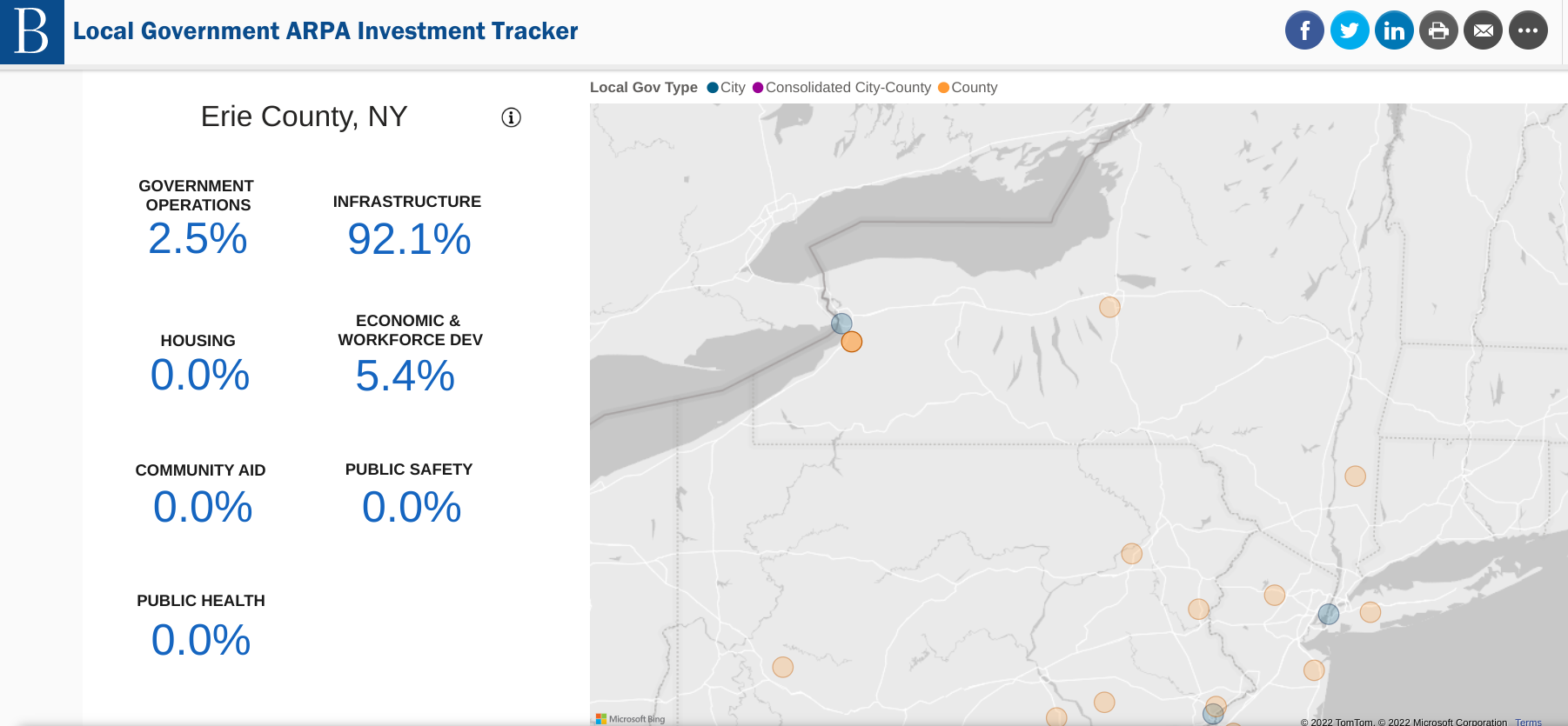
The Brookings ARPA Investment Tracker is one of several sites monitoring the use of grant funds. Erie County’s use of the funding is highlighted here with 92% of the funding being used for infrastructure purposes. Other New York State government interim reports can be found here.

But even with all of this publicly available information, and aggressive marketing by the vendor community, there seems to be a limited amount discussion about how these major federal grant funding programs can be woven into local geospatial initiatives.  And this is unfortunate because its very clear there ARE local activities which are “ARPA eligible” in the areas such infrastructure management, economic development, health and human services delivery, housing, transportation and community revitalization to name only a few.  So who is leading the statewide local government ARPA geospatial discussion?

Diving a little deeper, I took out attempting to survey the statewide local government geospatial community on the ARPA and IIJA programs by issuing a simple survey via the NYS GIS listserv, as well as having a link put on the NYS GIS Assocation’s website (thank you, Association webmasters).  Perhaps I would have gotten a better response to the survey offering links to both of the funding programs, but instead, wanted to capture the respondent’s immediate understanding/awareness of the programs when opening the survey.  Providing links to the programs would have defeated the purpose of the survey.   And I made it clear the survey was only for New York State local government users and/or their contractors.    That takes a lot of potential respondents off the table via the listserv and with local government representation in the Association hovering around less than 25% of the total membership, I wasn’t sure what the response would be.  Though not included in the images below, I emailed a handful of former county colleagues separately ahead of the online survey which resulted in very similar results.

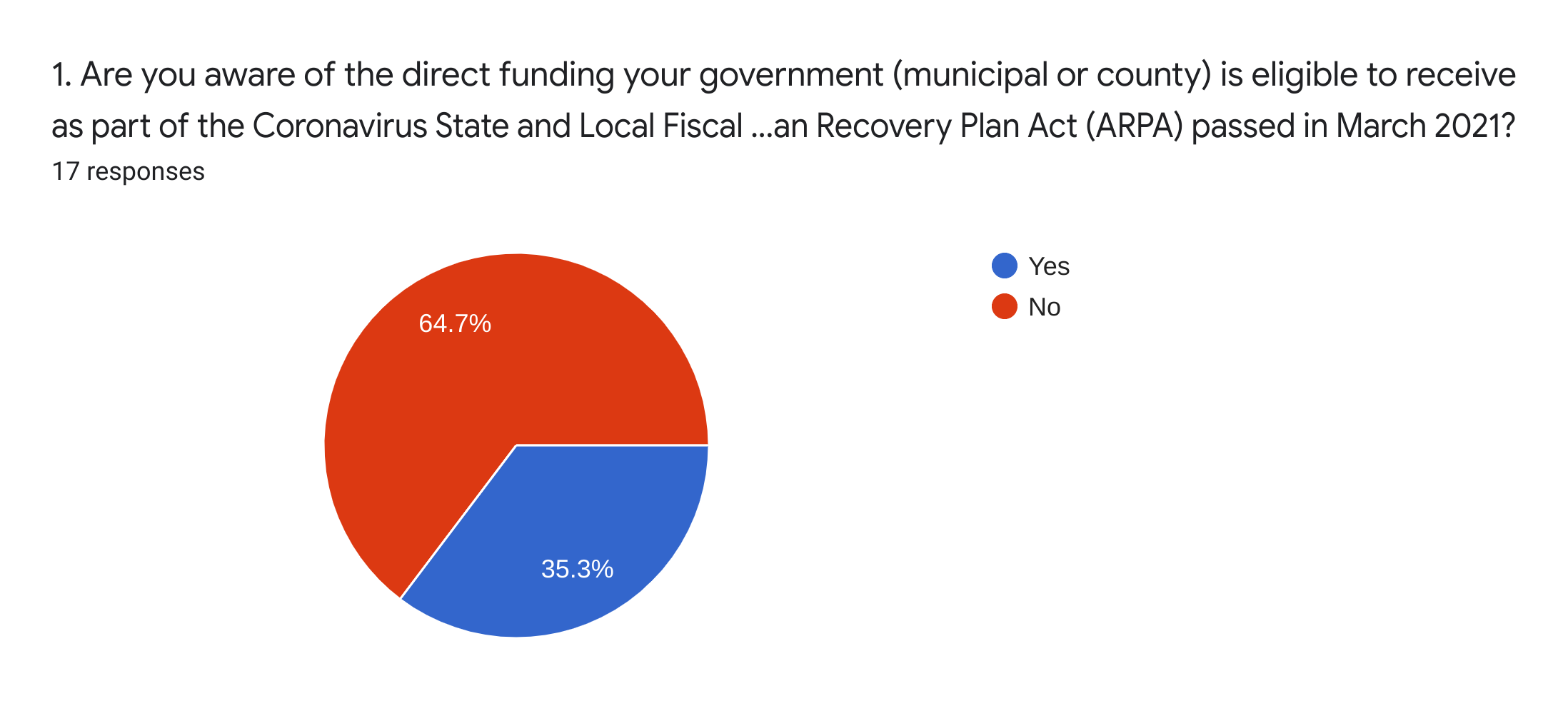
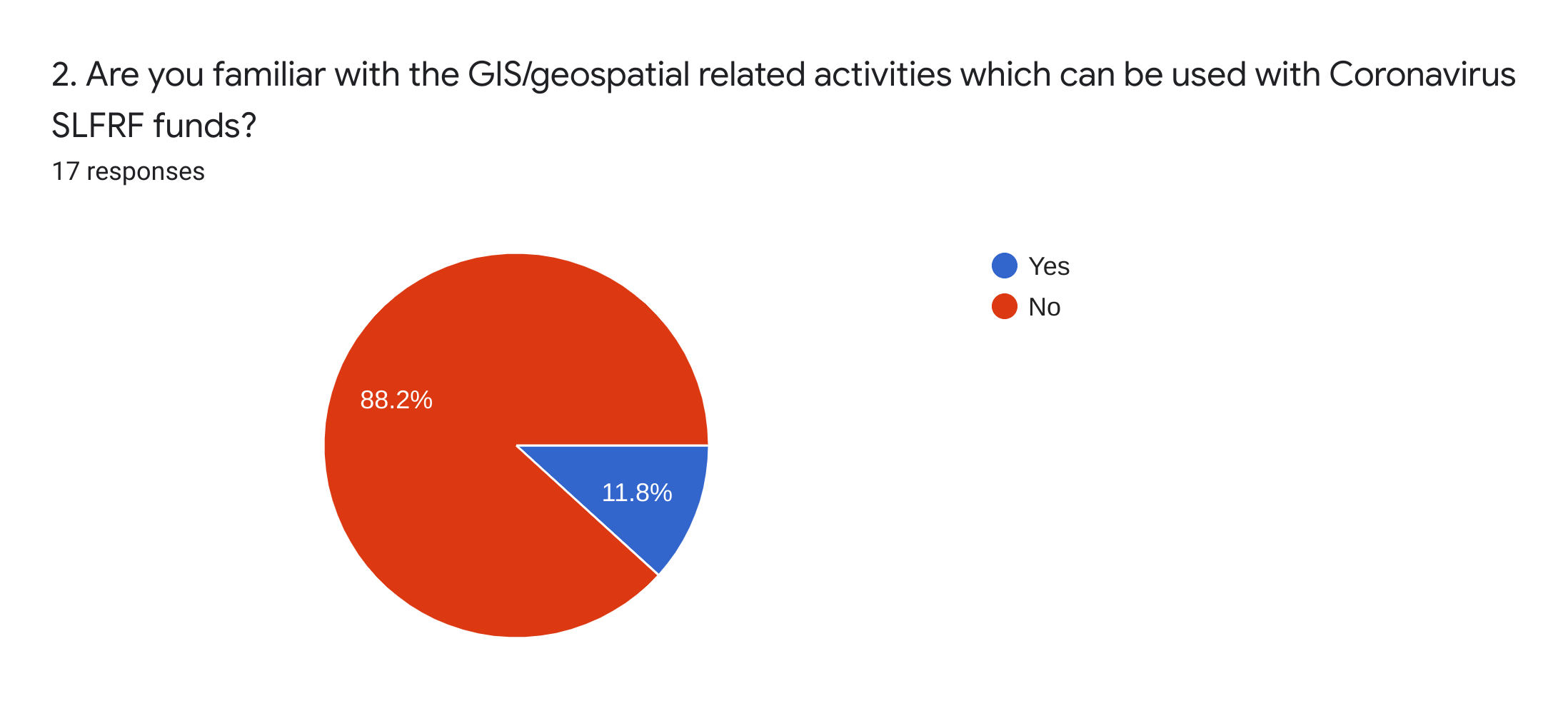
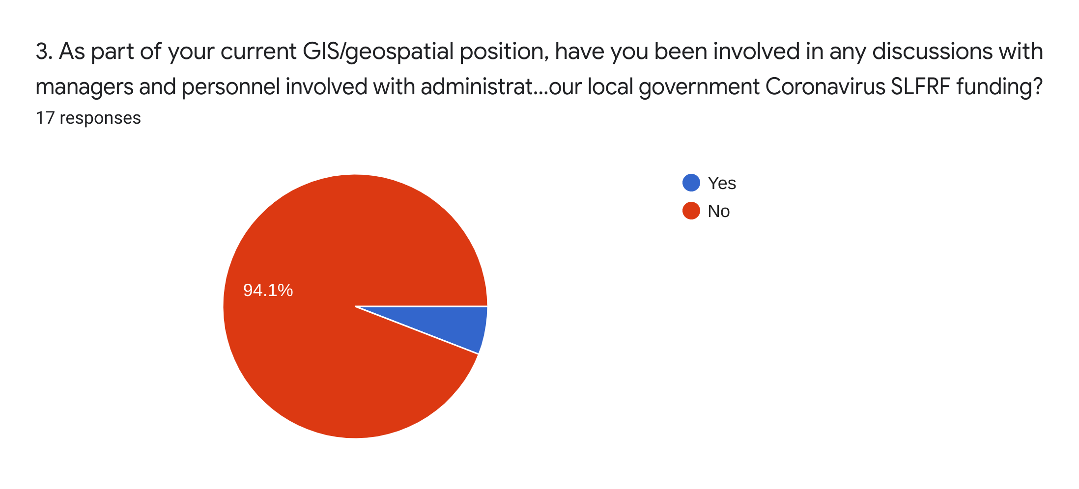
The results can hardly be considered a statistically representative sample of the statewide local government GIS user community.  I received only 20 responses of which 18 provided usable data.   As such, I would submit the following pie charts can be considered illustrative or reflectiveof the current overall awareness, if not understanding, of the current ARPA funding programs.  While only a third of the respondents indicated they were even aware of the ARPA program (first pie chart),  there was barely any understanding of the funding as it relates to geospatial (second pie chart) and only one of the respondents indicated he/she had been involved in any discussions regarding the use of ARPA funding (third pie chart) in their organization.   Though to some degree many GIS practitioners across the state often hold down technical positions in department-line staff positions which are normally far removed from the grant funds discussions being held in much higher administrative offices.

Unfortunately, as historically been the case, the top level NYS government associations noted above have rarely made GIS/geospatial a visible and outward facing part of their agenda.  Even today, Its hard to find anything really meaningful for the local government GIS community when using keyword searchs such as  “GIS, geospatial, or mapping” on any of their websites.  And its highly doubtful there will be, or can be, any real meaningful advocacy through any state program offices as this political or elected official outreach framework doesn’t even exist on behalf of local government GIS programs.    As the next generation of local government GIS/geospatial programs evolve, particularly in the urban environments where the focus will be more on the public infrastructure, utilities, sustainability and climate change impacts, large scale and high resolution mapping and surveying – the collective internet of things (IoT) – discussions and geospatial strategies with most state government offices in this space will  become more distant.    Geospatial programs for different levels of government in New York State evolving in completely different directions.   Albeit for sure New York City is on a different level when is comes to infrastructure and underground mapping, but it’s Underground Infrastructure Project concept does represent an important direction of the next generation of local government GIS programs in urban areas across the state.  It’s just a matter of degree.

The list below, from an ESRI publication and is available on numerous websites, highlights the local government programs in play.  No, not necessarily direct funding to your GIS office, but does serve as a roadmap of who GIS practioners should be talking with at the local level.  EcoDev, public health, infrastructure and public works, and cooperative efforts with utilities.  And then find out who is administering your government’s ARPA funding.    You can be assured someone or some agency has dibs on the funding.  And apparently the GIS programs are only visible in the rearview mirrow. 

The four major ARPA funding program areas include:

1.  Support public health expenditures, by, for example, funding COVID-19 mitigation efforts, medical expenses, behavioral healthcare, and certain public health and safety staff
2.  Address negative economic impacts caused by the public health emergency, including economic harms to workers, households, small businesses, impacted industries, and the public sector
3.  Replace lost public sector revenue, using this funding to provide government services to the extent of the reduction in revenue experienced due to the pandemic

4.  Invest in water, sewer, and broadband infrastructure, making necessary investments to improve access to clean drinking water, support vital wastewater and stormwater infrastructure, and to expand access to broadband internet

Within these overall categories, recipients have broad flexibility to decide how best to use this funding to meet the needs of their communities

While actually securing funding is much easier said than done, often requiring great grant and proposal writing skills as well as involving many individual offices and agendas in the organization.  But the almost complete lack of even a discussion by the statewide local government GIS/geospatial community to date seems amiss.

There are so few funding opportunities such as these 2021 federal grant programs to take advantage of.  These are generational programs.  Right now the onus of finding representation and advocacy for local government GIS funding in the federal grants arena falls squarely on local government GIS leaders and their representatives.  As well as local GIS practitioners.

Right now, though, the silence is deafening.

Taking a Peek Under the Hood: New York State GIS Association

How’s Your Regional GIS Association Group Doing? Biden’s Infrastructure Plan. And Dude, What’s Up with Senate Bill S1466?

Its mud season in the Adirondacks so outdoor activities are kinda slow in the North Country.  Not much on the trails and the black flies loom.  Similarly is the blog content, scrounging around for new material and the like.  Couple articles in development hoping to pull together over the next couple months.  Some cool stuff coming out of NYC.  Seemed like a good time to pull together some topics and issues I’ve been staring at for a while.  Much of it related, for the most part, to the NYS GIS Association.

New York State GIS Association Regional Groups

The end of last fall I started a conversation with a GIS colleague who was responsible coordinating meetings for a local/regional GIS user group. An honorable task given the amount of time and effort which goes into doing so – often solo or with only one or two other folks.  Our conversation focused on a combination of declining attendance and participation throughout the region albeit at the time this may have been more of factor of COVID.  The play book almost the same everywhere:  virtually no in-person meetings, Zoom fatigue, and/or in general everyone completely pre-occupied with the pandemic.  All of this adding to the challenge of working with others to develop and propose meeting themes which would/could focus on something other than COVID.  And as we all know, much easier said than done over the past 16 months.

Curbing my own personal thoughts and opinions about where the profession is headed in this space across the Empire State – fodder for another article and another day – I put together a short 10-question Google forms questionnaire which was sent to the 15 regional coordinators listed on the Association’s Regional Coordination Committee web page.

Response rate was actually very good as I received responses from 14 of the 15 individuals I sent surveys to.  One of the 14 opted not to complete the survey leaving only one coordinator not responding.   Selected questions are listed below for which I’ve included summary results.   A spreadsheet containing all questions and and responses by all respondents can be downloaded here.  For the purposes of this article I removed the name of the Regional User Group so responses could not be linked to a specific person or group.

Taking a look at some of the questions and grouped responses:

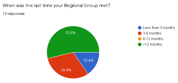
1. When was the last time your Regional Group met?

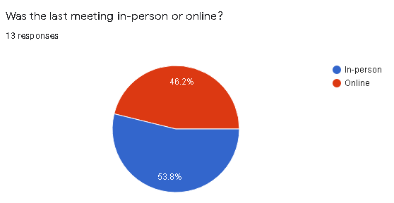
2.  Was the last meeting in-person or online?

3.  Whether in-person or online, how many people participated in the last meeting?

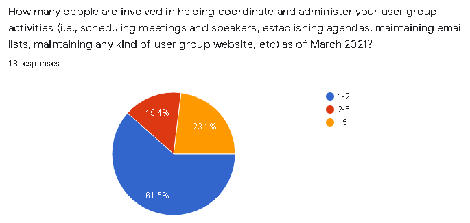
4.  How many people are involved in helping coordinate and administer your user group activities (i.e., scheduling meetings and speakers, establishing agendas, maintaining email lists, maintaining any kind of user group website, etc) as of March 2021?

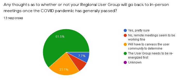
5.  Any thoughts as to whether or not your Regional User Group will go back to in-person meetings once the COVID pandemic has generally passed?

6.  Are any future Regional Group Meetings scheduled?

(Note:  During preparation of this article one Regional Group announced a Fall 2021 in-person meeting

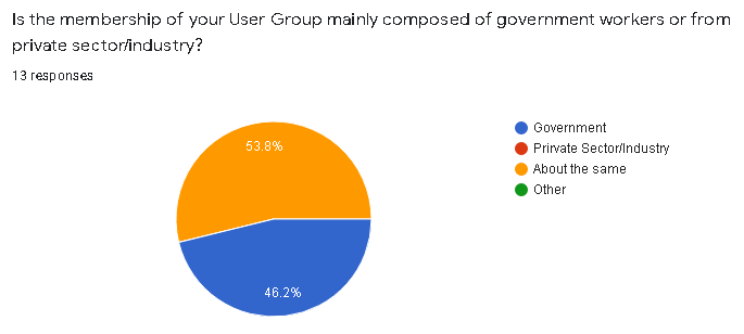
7.   Is the membership of your User Group mainly composed of government workers or from private sector/industry?

8.  When User Group Meetings are held, do the topics and content of discussion focus on local/regional geospatial issues or more on statewide GIS issues?

Synopsis

Given the high percentage of the number of regional coordinators who responded to the survey (14 of 15; one responding to me but not completing the survey) the information gathered should be considered reflective of the current activities and engagement of the regional groups.  Admittedly the survey was really only 10 questions and completed during our time of  COVID, thus one could argue that some of the organizational issues which the Association is facing is similar to other organizations due to the pandemic.

That said, couple immediate takeaways on the pulse of the Association’s regional groups:

While the pie chart shows nearly 54% (7 of 13) of the groups haven’t met in over 12 months, overall its probably closer to 60% as I suspect the two groups which did not respond to the survey have not met during the same time period as well.  One of those for sure.  Sixty percent is significant.

Closely related is the question about whether or not coordinators anticipate getting back to “in-person” meetings after the pandemic has passed.  Seemingly more relevant, however, was the issue of “re-energizing” the group first (61% or 8 of 13 responding).  My guess it’s safe to assume the other two survey non-respondents are in the same space or mindset – and the percentage goes to a whopping 66% – 10 of 15.  75% of those responding indicated the next meeting wasn’t even planned and again, if you throw in the non-respondents to this questions it goes to over 80%.

A noticeable feeling of malaise?  Seems like enough to give the Regional Coordination Committee Co-Chairs something to think about.

Findings to other questions which included, for the most part, anticipated results such as:

  • Meetings taking place (independent of how long ago) were about half in-person and half-online)
  • Numbers of people participating in meetings (in-person or online)
  • As we all have painfully come to know, normally a handful of people (in many cases only 1-2) individuals coordinating the group and meetings
  • Probably didn’t ask the question properly, but nonetheless it appears the groups are split about 50-50 on private/industry sector vs. government individuals; and
  • Meeting agendas/discussion tends to focus about 50-50 on local/regional issues vs. statewide issues

Biden’s Infrastructure Bill

I included the question about meeting content (local level vs. state level) to get a sense of the discussion as to who/what may be directing the narrative.  Why, you say?  How about Biden’s $2.3B Infrastructure Plan.  Rarely has so much federal money been allocated which links itself to local and regional GIS programs.  Roads, buildings and utilities, bridges, public transit, water and sewer systems, disaster resiliency, public schools, and much much more.  Large amounts of geographic features and systems best managed at the local level.  And with local resources.  If not local and regional governments themselves then with trusted consultants and business partners.  Engineering consultants with broad and capable geospatial capacity.

Yes, the time for local and regional geospatial programs to proactively and reach out to state organizations such as the NYS Association of Towns, NYS Association of Counties, ot NYS Conference of Mayors to work towards making sure this new funding sources are secured for local use and application in the geospatial space..  As well as enhancing collaborations and efforts with professional organizations such as the New York State Society of Professional Engineers and New York State Association of Professional Land Surveyors which have an established presence in Albany.

Of course state assets are in play with regard to this funding, but local and regional geospatial programs, in May 2021, cannot afford to sit on the sidelines to wait and later find out distribution of this new federal funding is going to state programs first and being left to fight for the remaining scraps. And/or left to some funding distribution formula which included no local and regional geospatial programs input.

Time now for local and regional GIS/geospatial programs and organizations to mobilize on this funding opportunity.

Senate Bill S1466

Hello, McFly? Anybody home?  Anybody watching and monitoring anything with regard to the state legislature and legislation which is connected  to the Empire State geospatial space?  In the big scheme of things, S1466 probably doesn’t amount to much but it does seem something is amiss in the broader context when the words Geographic Information Systems Mapping Technology are used in describing any proposed New York statewide legislation and it goes completely under the radar screen without review and input from the statewide geospatial community. Can’t say absolutely no discussion because something, on some level, some people, somewhere, were talking and exchanging information to frame the legislation.  Was the Association part of that discussion?  Or maybe your Geospatial Advisory Committee?

And a bigger head scratcher is connecting the state GIS office with “strategic planning and municipal study assistance”.   Specifically the proposed legislation reads, in part:

“The usage of available floor space within a given political subdivision
is a critical detail. Evaluation of floor space usage allows the local
area to understand how buildings are being used, and evaluate whether
new zoning or construction plans are needed to stimulate activity in
certain sectors. However, conducting a study through questionnaires and
or geographic information mapping (GIS) technology is difficult and
costly for local entities. On the other hand, the Office of Information
Technology Services already maintains statewide GIS information and can
readily adapt that material for more specific purposes.”

This legislation would allow towns, villages, cities, and counties to
request GIS and study assistance from OITS to undertake a review of
floor space usage. Such assistance could include specific GIS maps,
online questionnaires, and other technological methods that would assist
the conducting of such studies.

Maybe I need to get out more.  Granted, if passed, the whole process of ITS of getting involved presumably wouldn’t happen unless requested locally, though it is interesting to see this office ready to provide these professional services.  Also, interesting it hasn’t ruffled a few feathers in the professional planning and GIS consultant communities as well.  NYS Association of Regional Councils?

Almost two years ago I made reference to a similar geospatial community asleep at the wheel legislative moment with regard to Senate Bill 9061 involving Google Maps.  Have there been similar pieces of legislation?  In absence of full-time staff – including an Executive Director who can operate in the Albany space – its almost an impossible task on staying on top of pending legislation proposed by others.  To say the least of identifying sponsors and proposing legislation for the benefit of the industry and membership.

One way or another, the legislative space is where the Association needs to expand and build capacity.   Thus far it hasn’t been easy and will continue to be difficult to do so.


Google Earth in the Classrooms

Chromebooks, Google Classroom and Google Earth Together Provide a Framework for Teaching Geography and many other subjects in K-12

I actually started drafting an article on Google Earth in the classroom last fall but since then it’s been one thing or another pushing things to the back burner.  Mostly work priorities but then COVID-19 sent everything sideways.  Seemingly pointing us all in a new and uncharted direction.  A new and greater reliance on the internet as many of us found ourselves working remotely.

The remote work force in many of our extended families includes teachers of whom I now have even greater respect after watching what is involved in teaching remotely and online.  The lesson plans, prep work, surgically attached to the computer, and the seemingly endless hours of the encompassing interaction with students – and parents – well beyond the normal eight-hour work day.

In a roundabout way watching this teaching workflow unfold during the COVID lockdown brought me back to the Google Earth article.  Google’s presence in the classroom is ubiquitous built around Google Classroom which I can only imagine will grow immensely as remote K-12 education expands in the future.  Wrapped in with kabillons of lesson plans, templates, covering every education topic, discussion groups, forums, and blogs from around the world – everything built on top of Google technology.  Easily delivered and made available to the masses at all levels of the educational spectrum with the uber cheap and incredibly functional Google Chomebook.  (btw – using one as I type).   And easily accessible within this framework – and bringing me back to the beginning of this article – is the Google Earth product for use in the classroom.  It’s an incredible product to augment K-12 classroom teaching and not just for geography.

Continue reading

10 Questions: Larry Spraker

My guess the name Larry Spraker doesn’t need much of an introduction across the New York State and New England GIS landscape.   His work and contributions since the late 1980s to the geospatial community are many and have included efforts from academia, government, and for many years the private sector.  As well as a ton of volunteer work with GIS user groups and the like. It has been an privilege crossing paths with him in so many ways over the years.  

So depending on the time of day, I recommend grabbing your favorite beverage, pull up a chair and continue reading.  There’s a lot here.  And after you are done, close your eyes and envision Mr. Spraker in another time or comos. Or, as the immortal Rod Sterling would say on the Twilight Zone “Another Dimension”.  Under the bright lights, behind the desk, and waving his hands fevorishly.  Yup, that’s him in his new gig – performing his best Chris Berman “Swami Sez” imitation as he hosts the 6PM ESPN SportsCenter broadcast.

Enjoy.

eSpatiallyNewYork:  Let’s start from the beginning.   The Albany-area boy goes to SUNY Albany for undergraduate and then on to Indiana State for graduate work.  How and when did geography become your educational and professional focus? 

Spraker:  I originally went to UAlbany as a Communications major with aspirations to be a sportswriter. After realizing that was a tough gig that didn’t pay particularly well (at least back in the early 80’s), someone recommended Computer Science. After a few courses, I really liked programming, but hated the high-end math courses such as Calculus and Differential Equations. A minor in Computer Science didn’t require the math courses, so I went to my advisor and asked “What would be a good major with a Computer Science minor?”. He listed a number of majors that included Physics, Math, and the last one he mentioned was Geography. I had already taken 6 credits in Geography as electives, so I asked for more details and somehow this guy had a fair bit of knowledge in this area and explained just enough of cartography, GIS and remote sensing to pique my interest. I registered for Intro to Cartography and Intro to Remote Sensing the next semester and fell in love with the both courses, and quickly found my new major. I focused primarily in Remote Sensing as an undergrad, and my professor, Floyd Henderson, really encouraged me to go graduate school. At the time Indiana State University was a leading remote sensing program, having the first remote terminals into the mainframe computers at Purdue which was the state of the art for image processing software. Floyd knew the professors at ISU, wrote me a recommendation and helped me get a Research Assistantship, so I packed up my car with everything I owned and drove to Terre Haute, Indiana for 2 years and finished my Masters. Although I focused a lot on Remote Sensing, I got exposed to a lot of GIS as well, and by the end of grad school had really got the GIS bug.

As an aside, after I graduated from ISU and came back to the Capital District, Floyd called me and asked me if I would teach his Intro to Remote Sensing and Aerial Photo Interpretation classes while he was away on sabbatical that year. So I returned to SUNY Albany as an adjunct professor and taught his classes that year. When Floyd returned, I stayed on as an adjunct faculty member and transitioned to developing and teaching several GIS courses. I really enjoyed working with the students and ended up teaching at SUNY Albany for 17 years.

Continue reading

2019 Westchester GIS User Group Meeting

Making it the largest annual event to date, nearly 200 individuals attended the 2019 Westchester GIS User Group Meeting May 16th at Purchase College. The annual event included a diverse mixture of user presentations and demonstrations for attendees representing local and county government, utilities, nonprofits,  business and industry, and academia (both college and high school programs). Faculty and facility support from the College’s Environmental Studies program and sponsorship from twelve vendors again helped enable the Westchester County GIS community to meet and discuss the countywide geospatial agenda.  And by virtue of the venue, promoting SUNY GIS educational opportunities as well.   It was a great GIS day for all attending and participating.

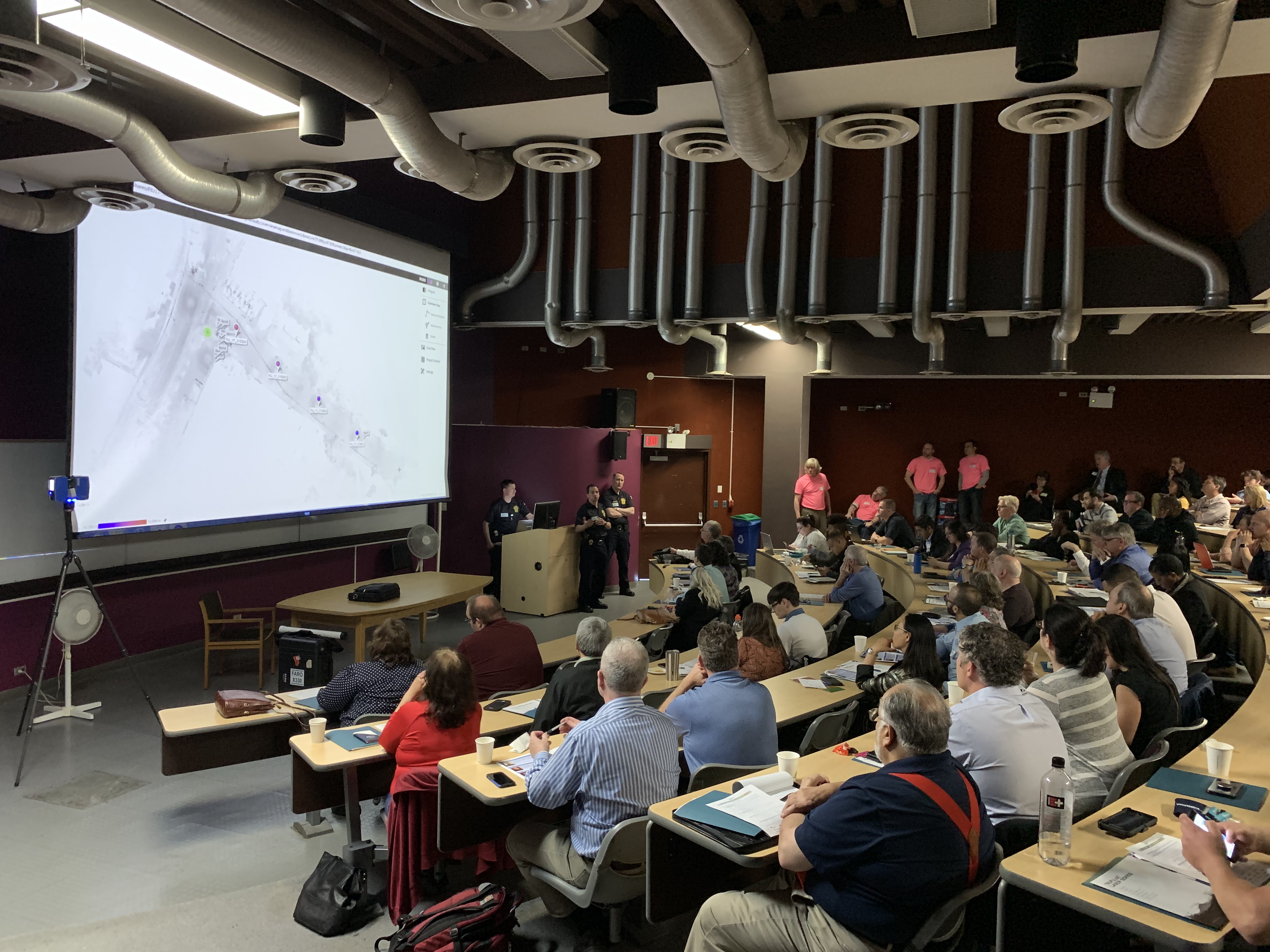
As the day progressed, nearly 200 registrants assembled as part of the 2019 Westchester GIS User Group Meeting at Purchase College. The main lecture auditorium was filled to capacity with standing room only by mid-morning.

2019 Agenda and Speakers

While the 2018 agenda had a specific theme, this year’s agenda was intended to be more diverse covering a wide range of topics including health and human services, pavement management systems, oblique imagery applications, training workshops, forestry inventories, public safety, mapping and visualizing the human brain, the 2020 Census, and a special presentation by ESRI focusing on accessing the County’s new planimetric datasets via web services.

Session I:  Allison McSpedon and Jeff Worden from the Westchester County Continuum of Care Partnership for the Homeless led the day off with a presentation focusing on the use of mobile technology as part of the annual Homeless Point in Time (PIT) Count taken in January 2019.  This was followed by Nancy Birnbaum, Manager of Software Architecture, Westchester County Dept. of Information Technology who presented the new Westchester County Online Community Mental Health Directory.

Managers from the Continuum of Care Partnership for the Homeless detailed the pros and cons on the use of mobile data collection technology as part of the January 2019 count. They anticipate even better results and ease of use when deployed in the next count.

Andrew Reinmann, Advanced Science Research Center, Graduate Center of CUNY and Department of Geography, Hunter College followed with the use of geospatial tools as part of the Westchester County Forestry Inventory: Mapping and Ecosystem Services Assessment.  The morning session ended with a series of lightning talks highlighting the use of the County’s new oblique imagery.

Session II: After intermission, VHB and staff from Westchester County Dept. of Public Works and Transportation discussed the new Smart Asset Management and Inventory System (SAMIS) application which was followed by an excellent demonstration on the use of Laser Scanning technology by the Westchester County Police Forensic Investigations Unit.  Patrick Gahagan, Technical Analyst at ESRI finished the morning session discussing advancements in civil engineering and surveying integration between the Autodesk and ESRI platforms.

Detectives from the County Police Forensic Unit captivated the audience on the use of laser scanning in crime scene investigations. GIS staff is now working with the Forensic Unit on integrating laser scanning data into the enterprise GIS environment.

Session III:  After lunch – and an audience participation session of GeoJeopardy – Jonathan A. N. Fisher, Ph.D., Director of the nearby Neurosensory Engineering Lab at the  New York Medical College in Valhalla provided an overview of his project called Neurodome which centers on the mapping of the human brain with an assortment of technology and visualization tools.   Daniel Wickens, Solution Engineer from ESRI then gave two overviews on “What’s New with ArcGIS Field Apps and ArcGIS Online.”  Concurrently in separate locations training classes were offered on how to use the new online CONNECTExplorer oblique imagery viewer and the ESRI “Explore Future Climate Change” tutorial.

Session IV:  The last section of the agenda was brief and included an update on mapping efforts association with the 2020 Census by Margaret Baker, Geographer, from the U.S. Census Bureau Manhattan office.  The final presentation by Westchester County GIS staff included the latest developments and anticipated upgrades to the Westchester County GIS website including the scheduled launch of the Westchester GIS Geospatial Gateway

Individual meeting presentations can be accessed and downloaded using this link.

The U.S. Census Bureau is ramping up for the 2020 Census and has a variety of mapping and geospatial products in their toolbox. GIS technology is essential in helping identify areas which have had low counts and responses.

Little Things Make it Work

I’ve written before about the small details which we believe enable the Annual Westchester GIS User Group Meeting to continue to be successful – and we’re the first to admit there is always the element of luck.  Even the weather matters.  To the extent possible, elements such as keeping the content and speakers “Westchester” focused, minimal –  if any –  registration fees, lots of time for interaction with the sponsors on the exhibit floor, and the centrally located venue at Purchase College – all matter. One of the ironies, and downsides, of having the show on a college campus in mid-to-late May is that spring semester is already over and students have fled campus.  However,  there is normally a handful attending looking for summer or full-time work and passing out resumes.    The naturally lighted vendor area in the Natural Sciences Building, albeit small, adds to the personal “feel” of the show.    Easy access and plenty of parking is also essential.  And don’t forget lots of proactive outreach to the professional organizations and societies  we work with on a day-to-day basis:  police/fire, engineering, surveying, public works, assessors, nonprofits, and the planning community.   The added message here is to encourage consultants which are supporting local governments across the county – to attend the meeting.  To learn more about accessing and leveraging Westchester County GIS products and services and how this improves service and cost efficiencies to municipalities they serve.   Individually, any of these items listed above may seem trivial,  but they all add up in delivering a show that will bring the same people back next year.

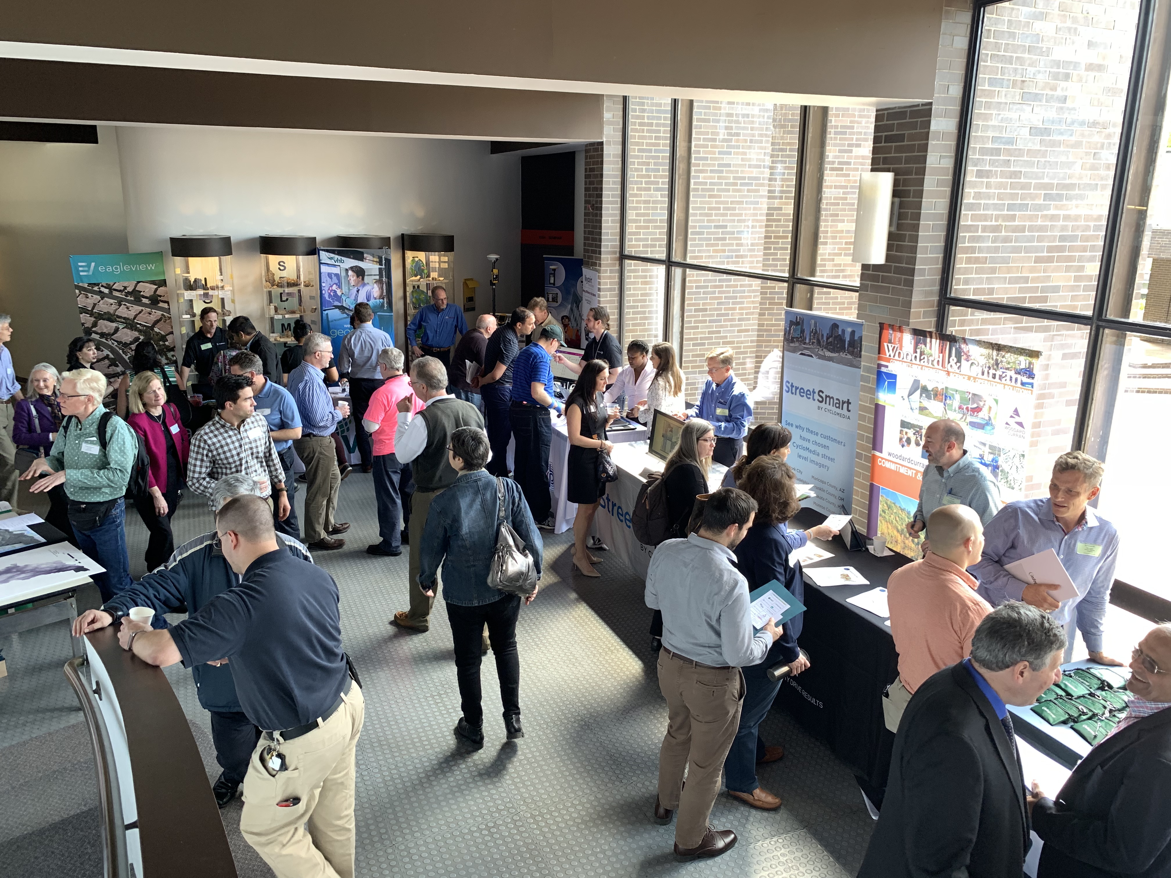
The exhibit floor was busy (and loud!) during breaks with all vendors noting interaction with attendees was good and productive. All attendees can complete a Vendor Bingo Card and be eligible for a raffle prize at the end of the day. This year’s prize was a vendor donated iPad!

Summary

Over the next couple weeks, conference organizers will be sending out a survey to both attendees and vendors to gather more detailed information on the various elements (presentations, speakers, refreshments/breaks, vendor interaction/feedback, facility issues and the like) of the show.  This information will help guide decisions about content and any changes that may need to be made, if any, about the structure of the show.

Staff will take a few months off and begin planning for the 2020 show in the fall of this year.  In doing so, we look forward to the continued relevance and position of the Westchester GIS User Group Meeting in promoting countywide geospatial development and use.

Geospatial Business Spotlight: EagleHawk One, Inc.

Company Name:                EagleHawk One, Inc

Website:                             www.eaglehawkone.com

Established:                       2016

Employees:                       6 + Nationwide network of certified drone pilots

EagleHawk was founded in 2016 by Willard Schulmeister and Patrick Walsh in Buffalo, NY, and has grown to be one of the most successful drone data and services operations in New York State today. Together they bring years of technological and business expertise to the fast moving startup company. Willard has a Master’s degree in Geographic Data Science and Geography from the University at Buffalo and Patrick holds a Master’s degrees in Aerospace Mechanical Engineering from the Rochester Institute of Technology as well as an MBA from Rollins College. Both are licensed sUAS (drone) pilots with the Federal Aviation Administration. EagleHawk has recently added Jonathan Byrd to its executive team. Jon holds an MBA from Harvard Business School and has over 15 years of experience in strategy, finance, engineering, and operations, and has held leadership roles in a variety of companies and industries. EagleHawk’s professional staff includes engineers, pilots, data scientists and industry experts located at their offices in Buffalo, Syracuse, Charlotte and Orlando, as well as other remote locations in the U.S.

EagleHawk has built a solid reputation within the drone community and has completed work for over 100 customers to date, many of which are repeat clients. EagleHawk is a Launch NY portfolio company and an Esri Emerging Business Partner. They are active in the NYS GIS Association and in both the central and western NYS GIS  communities. EagleHawk recently won $500,000 prize in GENIUSNY, the world’s largest business accelerator program for drone systems and technology based in Syracuse, NY.

Geospatial Products and Services

EagleHawk provides a portfolio of specialized services, but they are most often sought out by corporations, universities, and developers for their expertise in campus-wide aerial infrared roof inspections. To date, EagleHawk has inspected over 800 buildings and has found that nearly 80% of those roofs show signs of leaking.

The company has established a routine inspection program that empowers clients with a means to proactively manage and extend the average lifespan of their roofs, enabling a logical and fiscally responsible approach to capital planning and budgeting for roof maintenance. EagleHawk is currently developing a GIS-based asset management software solution that uses artificial intelligence and machine learning to derive meaningful insights from the data they collect.

EagleHawk specializes in the following areas:

  • Geographic Data Collection and Map/Data Processing
  • University and Corporate Campus Physical Inspections
  • Aerial Infrared Roof and Building Analysis
  • Utility and Infrastructure Inspections
  • Sensor Integration with UAV’s

A more detailed listing of EagleHawk’s services can be found at: www.eaglehawkllc.com/droneservices

University and Corporate Campus Mapping & Inspections

EagleHawk has conducted several large inspections for universities and corporate campuses throughout the Eastern United States.  For these projects, the campuses are carefully mapped in order to generate useful information for the inspection, such as building dimensional information, or roof elevation profiles.  EagleHawk conducts both façade and roof inspections  using advanced thermal imagers to detect issues not visible to the naked eye. EagleHawk certified data analysts conduct a building-by-building evaluation and generate meaningful insights from the data collection.

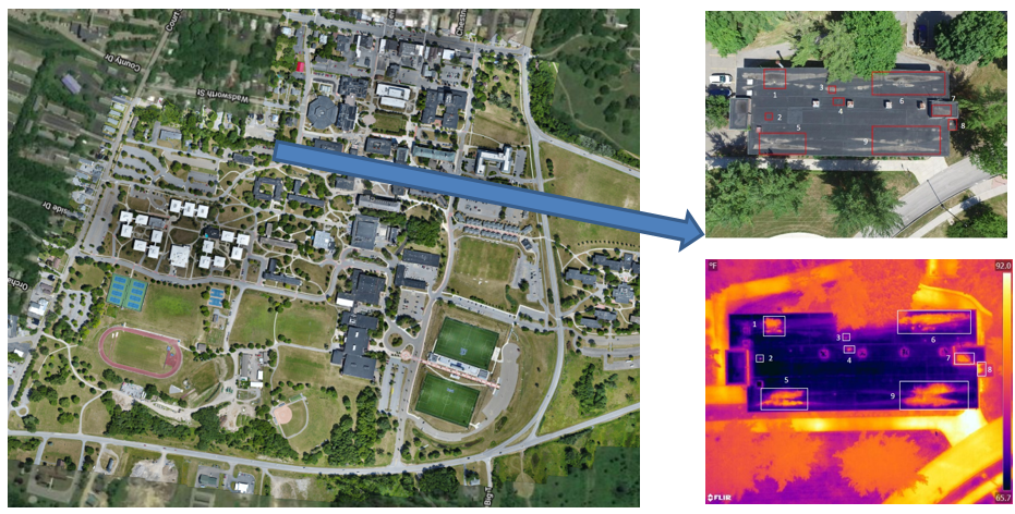
This image, from a SUNY campus, identifies wet and areas of concern within the building roof insulation invisible to the naked eye.  These areas are within the georeferenced “red rectangles” in the upper right image.

Pre-Construction Site Analysis

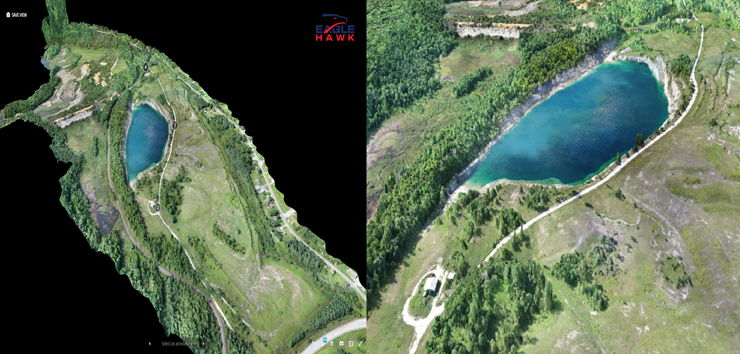
For this project EagleHawk collected approximately 550 acres of map data and imagery over a rural area in upstate New York for a client. Elevation data was needed for a pre-construction site analysis in order to determine if the area was viable for development.  EagleHawk generated an orthomosaic map, elevation contours and a massive 3D point cloud which allowed for critical decision making regarding plans at the site. This project was a great example of the benefits of drones in capturing geographic data for a large site effectively and efficiently.

For this upstate project, EagleHawk used two drones with 20MP cameras to collect imagery in one field day.  Imagery captured was processed to generate orthomosaic and topographic data delivered in common GIS & CAD formats. Clients receive the data as well as access to an interactive GIS with the data.

Buffalo Niagara Waterkeeper

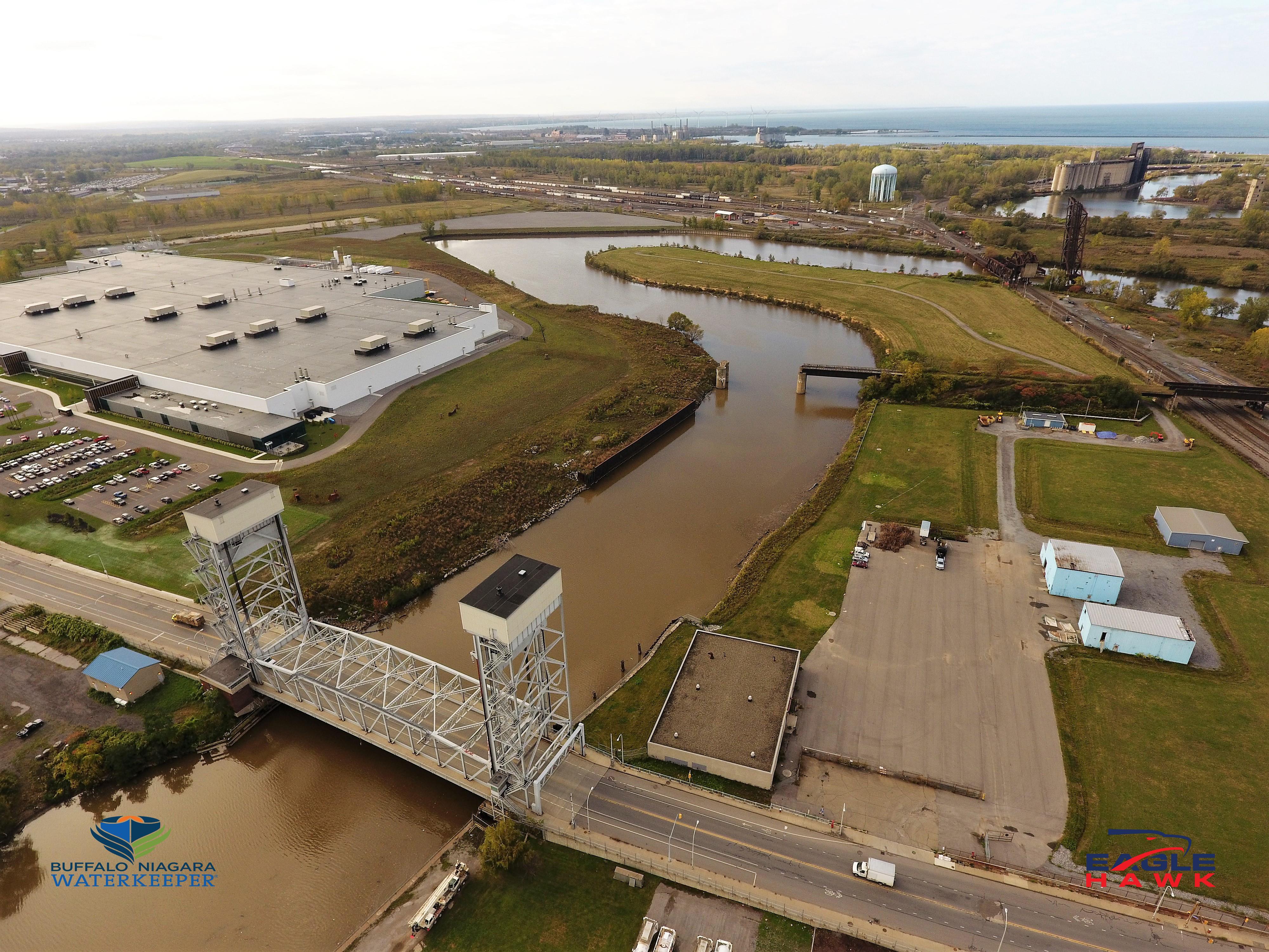
EagleHawk has worked with Buffalo Niagara Waterkeeper on more than a dozen different project sites throughout western New York including the Buffalo River, the Niagara River, Ellicott Creek and at Tifft Nature Preserve. EagleHawk collects aerial imagery and maps project sites to document change and also generates useful geographic data to aid in shoreline enhancements and restoration efforts.

The Buffalo River is one of eight habitat restoration projects in the Buffalo area that EagleHawk  is collecting imagery on.

Contact:

Patrick Walsh CEO – pwalsh@eaglehawkllc.com
Willard Schulmeister COO – wschulmeister@eaglehawkllc.com
Jonathan Byrd CFO – jbyrd@eaglehawkllc.com

EagleHawk One, Inc –  844-4-UAS-DATA  |   716-810-1042  | info@eaglehawkllc.com
FAA Certified Commercial Drone Operations

10 Questions: Rochelle Harris, President, New York State Assessors Association

Rochelle Harris, IAO, is the current President of the 900-member New York State Assessors Association which represents government assessors and industry representatives across the Empire State.  She currently serves as an assessor in both Madison and Chenango Counties.

eSpatiallyNewYork: You work in both Madison (Hamilton) and Chenango (Sherburne and North Norwich) Counties.  When did you begin to see computer mapping and technology changes in your offices?

 Harris:  I began to notice changes in 2009 – particularly in Chenango County – when a new County Real Property Tax Director was hired.  It was the first time that we were able to overlay aerial photography on top of the digital tax maps.

eSpatiallyNewYork: New York State Assessment Community Enterprise System (ACES) looks like a big deal – aka RPSV5.  How is this program moving along and the discussion within the Association?

Harris:  We are waiting for direction and an updated timetable from ORPTS.  There are also many pilot counties and municipalities which provide updates on progress and any issues. We will be holding training classes when the time comes.

eSpatiallyNewYork:  Do you feel there would be a benefit for more “GIS/computer mapping” training for the statewide assessor community?  Could better engagement with the GIS community improve this in anyway?

Harris: More education can never be a bad thing. Absolutely anything we can do to work together with another agency or organization makes all our lives more efficient. Our current training opportunities can be found on our website which is updated often.

eSpatiallyNewYork: Are you familiar with the New York State GIS Association?

 Harris: I actually am.  Keith Ducette, who is a GIS Technician with Onondaga County, introduced me to the organization and its programs.

eSpatiallyNewYork: Does the Assessors’ Association have anything like a GIS Work Group or GIS Committee?

Harris:  Currently, we do not, but if there is ever an overhaul or a reason to have one, we can create a special committee, or ask for volunteers for temporary projects such as ACES.

eSpatiallyNewYork: Has the Association ever approached the State to support/fund statewide capture of oblique (i.e., Pictometry/Eagleview) imagery?

Harris: No we have not, although it’s a great idea. There is a state senator trying to pass legislation for a cycle bill in which she suggests updating imagery and access to it.  We currently have access to oblique imagery in both Chenango and Madison Counties.

eSpatiallyNewYork:  With regard to data sharing – the conflict of “giving” digital assessment/tax parcel data away vs. “selling it” continues.  A mix across the state.   Does the Association have a position on this?

Harris:  My personal position, I have no problem giving the information for personal use but anyone who wants it for commercial and financial gain should pay for it.  We as an association do not have a position on this.  Chenango County offers a subscription service for the data while Madison County sells tax parcel data in file format.

eSpatiallyNewYork:  Do you anticipate any RPSV5 or any mapping items to be part of the Association’s 2019 Legislative Agenda? Revisions to 9NYCRR Part 189?

Harris:  We are working on our agenda and so far nothing on either issue though revising Part 189 would be a great idea.  The maps are cumbersome and in all three of my offices I am running out of places to store them.  I could mention this to our legislative chair and see if it is something we may be able to add to the agenda or suggest to one of the Senators we work with.

eSpatiallyNewYork: How are assessor’s “automating” in-field assessment work? What are some of the new technology tools?

Harris: I think when we get ACES  there will be much more opportunity to work with the program in the field as it will be mobile friendly and able to incorporate oblique imagery.  There are also digital tools to measure and draw new construction.  I know quite a few Assessor who solely use pictometry and the measuring tool on there.

eSpatiallyNewYork:  I see that you reference Josette Polzella on the President’s Page.  She was an early and vocal advocate of GIS in Westchester County going back to the late 1990s.     Tell me about your relationship with her.

Harris: Josette, was one of my very first mentors.  She was a wonderful person always willing to help and go the extra mile to help. We moved away from the Hudson Valley in 1988 and we lost touch.  We found each other on Facebook in around 2009 or so and picked right up where we left off. She sponsored me to take the IAO exam in 2010 and was there when I was installed – it meant the world to me. The world is a lot less bright without her in it.


10+ Questions: Eileen Allen

Eileen Allen is a familiar and respected face across the New York State GIS landscape.  First a foremost an instructor at SUNY Plattsburgh, she has instructed and mentored hundreds of students who are now part of the statewide geospatial fabric.  And in her spare time she has participated and contributed to numerous statewide GIS advisory committees over the past 20 years.  Always upbeat and a pleasure to work with, she is most certainly a first ballot lock for the GIS wing at the Hall of Fame in Cooperstown.  

eSpatiallyNewYork:  How long have you been at SUNY Plattsburgh?

Allen:  I was an undergraduate student at Plattsburgh State from 1973-1977.  In August 1984, I was hired to help finish a remote sensing research grant mapping historical beaver locations in the Adirondacks.  I’ve been here ever since.

eSpatiallyNewYork:  Where are you originally from and tell us about your journey that led to Plattsburgh.

Allen:  Both my husband and I grew up in Plattsburgh.  Fortunately there were state and federal programs to help me get a college education.  After college at SUNY Plattsburgh, I went to McGill and worked on a Master’s in physical geography.  Everything seemed to go wrong with my advisor and the research.  It was hard but necessary to leave there.   Fortunately, I could use my McGill credits and finish a Master’s program in Natural Resources at SUNY Plattsburgh while I worked on research projects.  I thought about getting my PhD but I just didn’t end up going in that direction.   Besides, I liked the research projects I was working on too much!

eSpatiallyNewYork:  You’ve been associated with the GIS program at Plattsburgh since its origin.  How did it get started?  Who was involved?

Allen:  My involvement with teaching GIS developed out of research projects and the need to train student workers. Dr. Richard Lamb was instrumental in developing the GIS courses and a minor in addition to his planning courses and practice.  He started the GIS course in the late-1990s and by the early-2000s we would take turns teaching the Introduction to GIS class.  I took over all the GIS classes when he retired and the Remote Sensing courses when Dr. Donald Bogucki retired.

But there is more, because so many chance occurrences determine our path.  Also, it has been noted that many more women are in GIS than in other natural sciences.  When taking college classes, I was often one of a very few or the only female.  Many people think that because GIS is so collaborative, women often gravitate towards it.  This is certainly true for me.

As an undergraduate, I was interested in many things but was unsure what I would major in and tried out several paths.  I needed a Social Science course and Physical Geography was on the list, so I took it.  Drs. Donald Bogucki (Geography) and Gerhard Gruendling (Biology) were working on a pilot project mapping wetlands and demonstrated this in their classes.  The grant was to investigate the use of remote sensing to estimate the impact of regulating the Richelieu River (the outflow of Lake Champlain, NY-VT) because of flooding concerns in Quebec.  Dr. Bogucki showed some color infrared imagery of wetlands in Physical Geography class and I was totally flabbergasted!  I absolutely had to be involved with the project!  It took several days for me to get the courage up to ask if I could be part of the research.  It so happened that they needed someone to use a transit to establish ground control.  I had been working with my father, a land surveyor, for many years and was enlisted by Dr. Bogucki to help set out targets and map them.

In the early 1970’s, it was very unusual for an ecologist and a geomorphologist to work together.  That was part of the attraction, though, where many of my interests could be combined. By chance, at about the same time, the Environmental Science Program was started at SUNY Plattsburgh and I had found my academic home.  I continued to be part of the project mapping Lake Champlain wetlands using custom flown 70-mm imagery until my graduation.
Continue reading

Views on the 2018 New York State Geospatial Landscape

There’s probably enough below for a couple blog posts but I ended up throwing everything in together and stirring it up – so to speak.  The language on Part 189 (tax mapping) could be a post by itself.  Kind of all over the place, even revisiting some topics I’ve touched on before as part of eSpatiallyNewYork.  Part wish list and part commentary.  Ten items. More or less.

  1. Promoting NYS Local and Regional Government GIS Development:  This is a frequent mantra of mine and with the  constant advancements in computing and geospatial technologies it’s worth considering on a regular basis.   And most certainly as part of this year’s wish list. Opportunities abound across the Empire State to help local and regional governments  jumpstart and/or solidify their GIS program.   For example, funding is available through the NYS Environmental Facilities Corporation focusing on infrastructure systems much of which is managed at the local level.  Or the large amounts of funding being made available as part of Zombie Remediation and Prevention Initiative through the NYS Office of the Attorney Genera  And the detailed inter-government discussions on the new Shared Services Initiative  which includes funding as part of the adopted FY2018 state budget.  GIS is the shared services technology. And regional GIS programs as part of the New York State Regional Economic Development Councils or by extension the New York State Economic Development Council?   GIS tools are at the foundation of economic development.   Not perfect fits,  but funding opportunities do exist in these program areas.

At the core of local and regional GIS programs is powerful server technology (local and hosted) that not only has the capabilities to support multi-government day-to-day business functions  but also provides the framework to publish geospatial content via map services.  Call it what you want Open Data, government transparency, or data sharing  but it is within this context that state agencies, nonprofits, academia, as well as  business and industry all have access to local data.  Let’s have 2018 statewide focused discussions on extending local and regional GIS capacity based on cost effective and server-based multi-government initiatives.

  1. Building GIS Association Legislative Capacity: While the Association has grown in so many positive ways over the past decade, the challenge continues for the organization to have its presence and mission heard in Albany’s governing hallways.  It is no small effort – organizationally and financially  to build this capacity.  Many similar professional organizations have full-time staff and Executive Directors whose job is to create awareness among elected officials, secure funding, and promote/influence legislation on behalf of the membership.    But currently the Association’s legislative efforts are in the hands of member volunteers.  And while Legislative Committee volunteers were able to coordinate a “Map Day” last May in Albany to introduce the Association to elected officials, the Association has yet to establish itself on the same playing field of recognition with other statewide geospatial heavyweights such as the New York State Society of Professional Engineering, New York State E911 Coordinators, and the lobbying efforts of large New York State based geospatial businesses.  Complicating the equation are Association members who hold licenses or certifications in other professions (i.e, engineering, surveying, photogrammetry, landscape architecture, AICP,  etc) and find themselves in a quandary as to support the Association’s agenda or the profession/discipline which holds their license.  To some degree, this issue manifest itself as part of the discussion with the Geospatial Data Act of 2017 which initially had lines of support drawn heavily along professional affiliation.  The Association must keep up the good effort and find a way to compete on the Albany stage.  Let’s hope the Legislative Committee can build upon its 2017 accomplishments and make further inroads in 2018.
  1. New York State Geospatial Data Act of 2018:   Not really,  but it DOES sounds great – right?   Close our eyes and make believe there is a state-equivalent of the much hyped (Albany) federal National Geospatial Data Act (NGDA) of 2017.   Just think of it:   A process across the Empire State in place to magically aggregate our local government tax-payer funded geospatial data assets into National Spatial Data Infrastructure (NSDI).  Newly appointed and designated state agencies responsible for providing support (similar to the designated federal agencies)  to make our geospatial contributions consistent with the federal data themes and standards as outlined in Section 6 and 7 of the proposed NGDA legislation.  Ultimately being made available via the GeoPlatformContinue reading