How’s Your Regional GIS Association Group Doing? Biden’s Infrastructure Plan. And Dude, What’s Up with Senate Bill S1466?
Its mud season in the Adirondacks so outdoor activities are kinda slow in the North Country. Not much on the trails and the black flies loom. Similarly is the blog content, scrounging around for new material and the like. Couple articles in development hoping to pull together over the next couple months. Some cool stuff coming out of NYC. Seemed like a good time to pull together some topics and issues I’ve been staring at for a while. Much of it related, for the most part, to the NYS GIS Association.
New York State GIS Association Regional Groups
The end of last fall I started a conversation with a GIS colleague who was responsible coordinating meetings for a local/regional GIS user group. An honorable task given the amount of time and effort which goes into doing so – often solo or with only one or two other folks. Our conversation focused on a combination of declining attendance and participation throughout the region albeit at the time this may have been more of factor of COVID. The play book almost the same everywhere: virtually no in-person meetings, Zoom fatigue, and/or in general everyone completely pre-occupied with the pandemic. All of this adding to the challenge of working with others to develop and propose meeting themes which would/could focus on something other than COVID. And as we all know, much easier said than done over the past 16 months.
Curbing my own personal thoughts and opinions about where the profession is headed in this space across the Empire State – fodder for another article and another day – I put together a short 10-question Google forms questionnaire which was sent to the 15 regional coordinators listed on the Association’s Regional Coordination Committee web page.
Response rate was actually very good as I received responses from 14 of the 15 individuals I sent surveys to. One of the 14 opted not to complete the survey leaving only one coordinator not responding. Selected questions are listed below for which I’ve included summary results. A spreadsheet containing all questions and and responses by all respondents can be downloaded here. For the purposes of this article I removed the name of the Regional User Group so responses could not be linked to a specific person or group.
Taking a look at some of the questions and grouped responses:
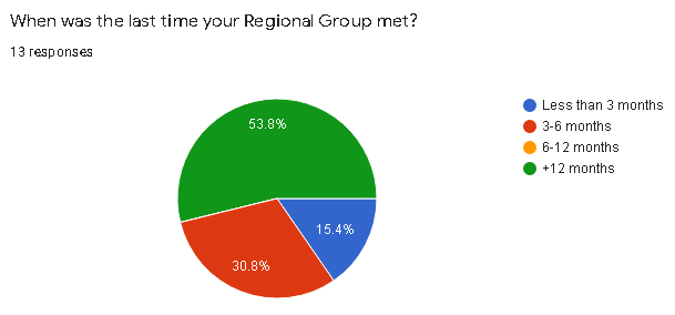
1. When was the last time your Regional Group met?
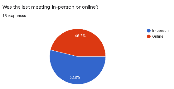
2. Was the last meeting in-person or online?
3. Whether in-person or online, how many people participated in the last meeting?

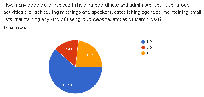
4. How many people are involved in helping coordinate and administer your user group activities (i.e., scheduling meetings and speakers, establishing agendas, maintaining email lists, maintaining any kind of user group website, etc) as of March 2021?
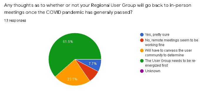
5. Any thoughts as to whether or not your Regional User Group will go back to in-person meetings once the COVID pandemic has generally passed?
6. Are any future Regional Group Meetings scheduled?
(Note: During preparation of this article one Regional Group announced a Fall 2021 in-person meeting

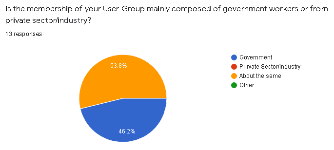
7. Is the membership of your User Group mainly composed of government workers or from private sector/industry?
8. When User Group Meetings are held, do the topics and content of discussion focus on local/regional geospatial issues or more on statewide GIS issues?

Synopsis
Given the high percentage of the number of regional coordinators who responded to the survey (14 of 15; one responding to me but not completing the survey) the information gathered should be considered reflective of the current activities and engagement of the regional groups. Admittedly the survey was really only 10 questions and completed during our time of COVID, thus one could argue that some of the organizational issues which the Association is facing is similar to other organizations due to the pandemic.
That said, couple immediate takeaways on the pulse of the Association’s regional groups:
While the pie chart shows nearly 54% (7 of 13) of the groups haven’t met in over 12 months, overall its probably closer to 60% as I suspect the two groups which did not respond to the survey have not met during the same time period as well. One of those for sure. Sixty percent is significant.
Closely related is the question about whether or not coordinators anticipate getting back to “in-person” meetings after the pandemic has passed. Seemingly more relevant, however, was the issue of “re-energizing” the group first (61% or 8 of 13 responding). My guess it’s safe to assume the other two survey non-respondents are in the same space or mindset – and the percentage goes to a whopping 66% – 10 of 15. 75% of those responding indicated the next meeting wasn’t even planned and again, if you throw in the non-respondents to this questions it goes to over 80%.
A noticeable feeling of malaise? Seems like enough to give the Regional Coordination Committee Co-Chairs something to think about.
Findings to other questions which included, for the most part, anticipated results such as:
- Meetings taking place (independent of how long ago) were about half in-person and half-online)
- Numbers of people participating in meetings (in-person or online)
- As we all have painfully come to know, normally a handful of people (in many cases only 1-2) individuals coordinating the group and meetings
- Probably didn’t ask the question properly, but nonetheless it appears the groups are split about 50-50 on private/industry sector vs. government individuals; and
- Meeting agendas/discussion tends to focus about 50-50 on local/regional issues vs. statewide issues
Biden’s Infrastructure Bill
I included the question about meeting content (local level vs. state level) to get a sense of the discussion as to who/what may be directing the narrative. Why, you say? How about Biden’s $2.3B Infrastructure Plan. Rarely has so much federal money been allocated which links itself to local and regional GIS programs. Roads, buildings and utilities, bridges, public transit, water and sewer systems, disaster resiliency, public schools, and much much more. Large amounts of geographic features and systems best managed at the local level. And with local resources. If not local and regional governments themselves then with trusted consultants and business partners. Engineering consultants with broad and capable geospatial capacity.
Yes, the time for local and regional geospatial programs to proactively and reach out to state organizations such as the NYS Association of Towns, NYS Association of Counties, ot NYS Conference of Mayors to work towards making sure this new funding sources are secured for local use and application in the geospatial space.. As well as enhancing collaborations and efforts with professional organizations such as the New York State Society of Professional Engineers and New York State Association of Professional Land Surveyors which have an established presence in Albany.
Of course state assets are in play with regard to this funding, but local and regional geospatial programs, in May 2021, cannot afford to sit on the sidelines to wait and later find out distribution of this new federal funding is going to state programs first and being left to fight for the remaining scraps. And/or left to some funding distribution formula which included no local and regional geospatial programs input.
Time now for local and regional GIS/geospatial programs and organizations to mobilize on this funding opportunity.
Hello, McFly? Anybody home? Anybody watching and monitoring anything with regard to the state legislature and legislation which is connected to the Empire State geospatial space? In the big scheme of things, S1466 probably doesn’t amount to much but it does seem something is amiss in the broader context when the words Geographic Information Systems Mapping Technology are used in describing any proposed New York statewide legislation and it goes completely under the radar screen without review and input from the statewide geospatial community. Can’t say absolutely no discussion because something, on some level, some people, somewhere, were talking and exchanging information to frame the legislation. Was the Association part of that discussion? Or maybe your Geospatial Advisory Committee?
And a bigger head scratcher is connecting the state GIS office with “strategic planning and municipal study assistance”. Specifically the proposed legislation reads, in part:
“The usage of available floor space within a given political subdivision
is a critical detail. Evaluation of floor space usage allows the local
area to understand how buildings are being used, and evaluate whether
new zoning or construction plans are needed to stimulate activity in
certain sectors. However, conducting a study through questionnaires and
or geographic information mapping (GIS) technology is difficult and
costly for local entities. On the other hand, the Office of Information
Technology Services already maintains statewide GIS information and can
readily adapt that material for more specific purposes.”
This legislation would allow towns, villages, cities, and counties to
request GIS and study assistance from OITS to undertake a review of
floor space usage. Such assistance could include specific GIS maps,
online questionnaires, and other technological methods that would assist
the conducting of such studies.
Maybe I need to get out more. Granted, if passed, the whole process of ITS of getting involved presumably wouldn’t happen unless requested locally, though it is interesting to see this office ready to provide these professional services. Also, interesting it hasn’t ruffled a few feathers in the professional planning and GIS consultant communities as well. NYS Association of Regional Councils?
Almost two years ago I made reference to a similar geospatial community asleep at the wheel legislative moment with regard to Senate Bill 9061 involving Google Maps. Have there been similar pieces of legislation? In absence of full-time staff – including an Executive Director who can operate in the Albany space – its almost an impossible task on staying on top of pending legislation proposed by others. To say the least of identifying sponsors and proposing legislation for the benefit of the industry and membership.
One way or another, the legislative space is where the Association needs to expand and build capacity. Thus far it hasn’t been easy and will continue to be difficult to do so.