2019 Westchester GIS User Group Meeting

Making it the largest annual event to date, nearly 200 individuals attended the 2019 Westchester GIS User Group Meeting May 16th at Purchase College. The annual event included a diverse mixture of user presentations and demonstrations for attendees representing local and county government, utilities, nonprofits,  business and industry, and academia (both college and high school programs). Faculty and facility support from the College’s Environmental Studies program and sponsorship from twelve vendors again helped enable the Westchester County GIS community to meet and discuss the countywide geospatial agenda.  And by virtue of the venue, promoting SUNY GIS educational opportunities as well.   It was a great GIS day for all attending and participating.

As the day progressed, nearly 200 registrants assembled as part of the 2019 Westchester GIS User Group Meeting at Purchase College. The main lecture auditorium was filled to capacity with standing room only by mid-morning.

2019 Agenda and Speakers

While the 2018 agenda had a specific theme, this year’s agenda was intended to be more diverse covering a wide range of topics including health and human services, pavement management systems, oblique imagery applications, training workshops, forestry inventories, public safety, mapping and visualizing the human brain, the 2020 Census, and a special presentation by ESRI focusing on accessing the County’s new planimetric datasets via web services.

Session I:  Allison McSpedon and Jeff Worden from the Westchester County Continuum of Care Partnership for the Homeless led the day off with a presentation focusing on the use of mobile technology as part of the annual Homeless Point in Time (PIT) Count taken in January 2019.  This was followed by Nancy Birnbaum, Manager of Software Architecture, Westchester County Dept. of Information Technology who presented the new Westchester County Online Community Mental Health Directory.

Managers from the Continuum of Care Partnership for the Homeless detailed the pros and cons on the use of mobile data collection technology as part of the January 2019 count. They anticipate even better results and ease of use when deployed in the next count.

Andrew Reinmann, Advanced Science Research Center, Graduate Center of CUNY and Department of Geography, Hunter College followed with the use of geospatial tools as part of the Westchester County Forestry Inventory: Mapping and Ecosystem Services Assessment.  The morning session ended with a series of lightning talks highlighting the use of the County’s new oblique imagery.

Session II: After intermission, VHB and staff from Westchester County Dept. of Public Works and Transportation discussed the new Smart Asset Management and Inventory System (SAMIS) application which was followed by an excellent demonstration on the use of Laser Scanning technology by the Westchester County Police Forensic Investigations Unit.  Patrick Gahagan, Technical Analyst at ESRI finished the morning session discussing advancements in civil engineering and surveying integration between the Autodesk and ESRI platforms.

Detectives from the County Police Forensic Unit captivated the audience on the use of laser scanning in crime scene investigations. GIS staff is now working with the Forensic Unit on integrating laser scanning data into the enterprise GIS environment.

Session III:  After lunch – and an audience participation session of GeoJeopardy – Jonathan A. N. Fisher, Ph.D., Director of the nearby Neurosensory Engineering Lab at the  New York Medical College in Valhalla provided an overview of his project called Neurodome which centers on the mapping of the human brain with an assortment of technology and visualization tools.   Daniel Wickens, Solution Engineer from ESRI then gave two overviews on “What’s New with ArcGIS Field Apps and ArcGIS Online.”  Concurrently in separate locations training classes were offered on how to use the new online CONNECTExplorer oblique imagery viewer and the ESRI “Explore Future Climate Change” tutorial.

Session IV:  The last section of the agenda was brief and included an update on mapping efforts association with the 2020 Census by Margaret Baker, Geographer, from the U.S. Census Bureau Manhattan office.  The final presentation by Westchester County GIS staff included the latest developments and anticipated upgrades to the Westchester County GIS website including the scheduled launch of the Westchester GIS Geospatial Gateway

Individual meeting presentations can be accessed and downloaded using this link.

The U.S. Census Bureau is ramping up for the 2020 Census and has a variety of mapping and geospatial products in their toolbox. GIS technology is essential in helping identify areas which have had low counts and responses.

Little Things Make it Work

I’ve written before about the small details which we believe enable the Annual Westchester GIS User Group Meeting to continue to be successful – and we’re the first to admit there is always the element of luck.  Even the weather matters.  To the extent possible, elements such as keeping the content and speakers “Westchester” focused, minimal –  if any –  registration fees, lots of time for interaction with the sponsors on the exhibit floor, and the centrally located venue at Purchase College – all matter. One of the ironies, and downsides, of having the show on a college campus in mid-to-late May is that spring semester is already over and students have fled campus.  However,  there is normally a handful attending looking for summer or full-time work and passing out resumes.    The naturally lighted vendor area in the Natural Sciences Building, albeit small, adds to the personal “feel” of the show.    Easy access and plenty of parking is also essential.  And don’t forget lots of proactive outreach to the professional organizations and societies  we work with on a day-to-day basis:  police/fire, engineering, surveying, public works, assessors, nonprofits, and the planning community.   The added message here is to encourage consultants which are supporting local governments across the county – to attend the meeting.  To learn more about accessing and leveraging Westchester County GIS products and services and how this improves service and cost efficiencies to municipalities they serve.   Individually, any of these items listed above may seem trivial,  but they all add up in delivering a show that will bring the same people back next year.

The exhibit floor was busy (and loud!) during breaks with all vendors noting interaction with attendees was good and productive. All attendees can complete a Vendor Bingo Card and be eligible for a raffle prize at the end of the day. This year’s prize was a vendor donated iPad!

Summary

Over the next couple weeks, conference organizers will be sending out a survey to both attendees and vendors to gather more detailed information on the various elements (presentations, speakers, refreshments/breaks, vendor interaction/feedback, facility issues and the like) of the show.  This information will help guide decisions about content and any changes that may need to be made, if any, about the structure of the show.

Staff will take a few months off and begin planning for the 2020 show in the fall of this year.  In doing so, we look forward to the continued relevance and position of the Westchester GIS User Group Meeting in promoting countywide geospatial development and use.

10 Questions: Rochelle Harris, President, New York State Assessors Association

Rochelle Harris, IAO, is the current President of the 900-member New York State Assessors Association which represents government assessors and industry representatives across the Empire State.  She currently serves as an assessor in both Madison and Chenango Counties.

eSpatiallyNewYork: You work in both Madison (Hamilton) and Chenango (Sherburne and North Norwich) Counties.  When did you begin to see computer mapping and technology changes in your offices?

 Harris:  I began to notice changes in 2009 – particularly in Chenango County – when a new County Real Property Tax Director was hired.  It was the first time that we were able to overlay aerial photography on top of the digital tax maps.

eSpatiallyNewYork: New York State Assessment Community Enterprise System (ACES) looks like a big deal – aka RPSV5.  How is this program moving along and the discussion within the Association?

Harris:  We are waiting for direction and an updated timetable from ORPTS.  There are also many pilot counties and municipalities which provide updates on progress and any issues. We will be holding training classes when the time comes.

eSpatiallyNewYork:  Do you feel there would be a benefit for more “GIS/computer mapping” training for the statewide assessor community?  Could better engagement with the GIS community improve this in anyway?

Harris: More education can never be a bad thing. Absolutely anything we can do to work together with another agency or organization makes all our lives more efficient. Our current training opportunities can be found on our website which is updated often.

eSpatiallyNewYork: Are you familiar with the New York State GIS Association?

 Harris: I actually am.  Keith Ducette, who is a GIS Technician with Onondaga County, introduced me to the organization and its programs.

eSpatiallyNewYork: Does the Assessors’ Association have anything like a GIS Work Group or GIS Committee?

Harris:  Currently, we do not, but if there is ever an overhaul or a reason to have one, we can create a special committee, or ask for volunteers for temporary projects such as ACES.

eSpatiallyNewYork: Has the Association ever approached the State to support/fund statewide capture of oblique (i.e., Pictometry/Eagleview) imagery?

Harris: No we have not, although it’s a great idea. There is a state senator trying to pass legislation for a cycle bill in which she suggests updating imagery and access to it.  We currently have access to oblique imagery in both Chenango and Madison Counties.

eSpatiallyNewYork:  With regard to data sharing – the conflict of “giving” digital assessment/tax parcel data away vs. “selling it” continues.  A mix across the state.   Does the Association have a position on this?

Harris:  My personal position, I have no problem giving the information for personal use but anyone who wants it for commercial and financial gain should pay for it.  We as an association do not have a position on this.  Chenango County offers a subscription service for the data while Madison County sells tax parcel data in file format.

eSpatiallyNewYork:  Do you anticipate any RPSV5 or any mapping items to be part of the Association’s 2019 Legislative Agenda? Revisions to 9NYCRR Part 189?

Harris:  We are working on our agenda and so far nothing on either issue though revising Part 189 would be a great idea.  The maps are cumbersome and in all three of my offices I am running out of places to store them.  I could mention this to our legislative chair and see if it is something we may be able to add to the agenda or suggest to one of the Senators we work with.

eSpatiallyNewYork: How are assessor’s “automating” in-field assessment work? What are some of the new technology tools?

Harris: I think when we get ACES  there will be much more opportunity to work with the program in the field as it will be mobile friendly and able to incorporate oblique imagery.  There are also digital tools to measure and draw new construction.  I know quite a few Assessor who solely use pictometry and the measuring tool on there.

eSpatiallyNewYork:  I see that you reference Josette Polzella on the President’s Page.  She was an early and vocal advocate of GIS in Westchester County going back to the late 1990s.     Tell me about your relationship with her.

Harris: Josette, was one of my very first mentors.  She was a wonderful person always willing to help and go the extra mile to help. We moved away from the Hudson Valley in 1988 and we lost touch.  We found each other on Facebook in around 2009 or so and picked right up where we left off. She sponsored me to take the IAO exam in 2010 and was there when I was installed – it meant the world to me. The world is a lot less bright without her in it.


Geospatial Business Spotlight: Ecology and Environment, Inc.

Company Name:                  Ecology and Environment, Inc.

Location:                               Lancaster, New York

Website:                                www.ene.com

Established:                         1970

Ecology and Environment, Inc., (E & E) is a global network of innovators and problem solvers, dedicated professionals, and industry leaders in scientific, engineering, and planning disciplines working together with our clients to develop technically sound, science-based solutions to the leading environmental challenges of our time. Founded in 1970 in Lancaster, NY, E & E also has offices in New York City and Albany, as well as locations across the national and internationally. E & E is a fully integrated environmental and engineering company delivering expertise across energy, site assessment and remediation, and restoration and resilience practice areas.

Geospatial Products and Services:

In October 2018, E & E’s IT/GIS group was rebranded as the Data Intelligence Group (DIG) to better reflect the capabilities and services of the department, and how that translates into identifying and integrating opportunities for innovation and streamlined data management into client projects. DIG includes experienced professional application developers and geospatial analysts who collaborate to add value for clients by providing tailored tools to collect and manage data efficiently, collate information quickly to meet aggressive schedules, accurately visualize project data, and support community engagement and project collaboration. E & E has worked on thousands of IT and GIS projects, and has built an extensive library of code that can be efficiently leveraged to complete successful new applications for clients quickly.

Specific E & E geospatial services include:

  • Custom Application development (public and private websites)
  • Needs Assessment, System Design, Development, Implementation and Maintenance
  • Database Development and Data Management
  • Data Visualizations (e.g., Tableau, ArcGIS Insights)
  • Field Data Collection and Management (GPS, Mobile Mapping)
  • GPS/GNSS Support
  • Mobile map viewers and custom mobile application development
  • 3D Visualization and Modeling
  • Photo Simulations
  • Software and system integration
  • Website design, hosting, and maintenance
  • Document Management
  • Satellite Image Processing
  • Database design, interpretation, and migration
  • Training and Technology transfer
  • Web-integrated Monitoring of Telemetered Data Feeds
  • Unmanned Aerial System (UAS) Site Survey
  • Augmented and Virtual Reality
  • GIS Process and Workflow Analysis
  • GIS Training
  • Desktop Geospatial Services (e.g., Cartography/Report quality mapping, Geospatial Analysis, Spatial interpolation and Modeling)
  • Process Automation

Mapping Offshore Wind for NYSERDA

To support New York State’s commitment under the Clean Energy Standard, which requires that 50 percent of the State’s electricity come from renewable energy sources, E & E worked closely with the New York State Energy and Research Development Authority (NYSERDA) to contribute to the first-of-its-kind New York State Offshore Wind Master Plan. The plan lays out a path for development of 2.4 gigawatts of offshore wind – enough to power 1.2 million homes. Geospatial tasks associated with this project included:

  • Development of an interactive web mapping portal for team and public engagement
  • Offshore and near-shore data acquisition
  • Geostatistics of potential offshore wind development areas
  • Development of detailed map figures for published reports

Areas for consideration and indicative wind energy areas were one result of the GIS analysis performed with NYSERDA.   NYSERDA’s findings were presented to the Bureau of Ocean Energy Management to assist in designating official wind energy lease areas.

E & E also developed GIS modeling that ranked sensitivity of various offshore species receptor groups to the stressors of building and operating a wind farm over different times of the year. Geospatial data and analysis results were used to facilitate identification of areas for consideration for offshore wind development and will inform future developers, potentially reducing the uncertainty and costs of their proposals.  Download a copy of the actual Offshore Wind Master Plan.

Geospatial Services for Erie County Water Authority

E & E is proud to have worked with the Erie County Water Authority (ECWA) since 2003, helping them integrate and leverage increasingly robust geospatial technologies to benefit their customers and their bottom line. E & E’s GIS support has been critical to their day-to-day operations. E & E GIS support has provided:

  • Field crew mobile access to utility information though maps and data,
  • Analysis of water main leaks to target most-effective replacements, facilitating smart capital improvement project planning, and
  • Transportation logistical support by optimizing service calls to save on transportation and labor costs.

GIS has played a significant role in the location and management of assets at ECWA for the past 25 years. Pictured here is a web mapping application for use in the office, with field laptops, and mobile devices, that assists with locating and identifying assets and related information.

Geospatial Flows for Energy Infrastructure Developers

For the Williams Transco 197-mile Atlantic Sunrise project, E & E set up field data workflows for a large environmental survey. In communication with E & E biologists, developers, and the client, E & E developed a customized workflow to meet diverse needs. Solutions included development of a customized ArcPad (Trimble) and ESRI Collector Application, web integration, and desktop automation tools.

ESRI Collector and the ArcGIS Online platform played an important role in the Atlantic Sunrise field data collection process. Data was integrated in near real-time and was made immediately available to project managers, engineers, and decision makers.


Working Smarter with E-Datasheets

E & E has ditched paper datasheets and is going green! We developed custom “smart forms” that utilize drop-down menus, radio buttons, and behind-the-scenes calculations to speed up the data collection process. These electronic datasheets save time and improve data quality.  Data is stored in an enterprise database and can be queried and exported to PDF format for report submittal.  E-Datasheets have been used with a wide variety of clients.

E & E has developed electronic datasheets to save time, improve data quality, and reduce waste.

Contact:

Greg Coniglio, PMP, GISP
Ecology and Environment
368 Pleasant View Drive
Lancaster, New York 14086
gconiglio@ene.com

Shared Services: Opportunities for Local Government GIS

More than a couple years ago, Linda Rockwood, who at the time was running Mohawk Valley GIS, mentioned to the NYS GIS community that she was at a local meet and greet with regional elected officials and mentioned the “GIS” word to one of NYS’s congressional representatives in attendance.  To her amazement – and dismay –  she found out the representative had a very limited awareness or understanding of GIS.

Linda’s encounter certainly wasn’t the first of its kind and I’m sure there have been numerous similar incidents in our respective corners of the state since then.  GISers gingerly starting a conversation on the broad benefits and applications of geospatial technology to government and elected officials – only to see the focus wander quickly. Maybe two or three minutes into the discussion when comparisons to Google Maps normally kick-in and/or there is eye contact with the next constituent and thinking moves to that conversation.

Unfortunately, the message – and the collective mission – seems to continue to get lost and there is recent anecdotal evidence to suggest there is still a long way to go in context of recognizing and embracing geospatial technology in NYS local governments (county, city, town, and village) as part of an increasingly important government program area:  Shared Services.

New York State Shared Services Program

Those working throughout the local government ranks should be on some level familiar with the shared services buzzword.  It’s the talk among government officials and for legitimately good reasons.  Look no further than Governor Cuomo’s commitment of $225 million in the FY 2019 Executive Budget to continue the County-Wide Shared Services Initiatives (CWSSI). The $225 serves as matching funds for a one-time match for actual and demonstrable first-year savings achieved by the Shared Services Panels through new actions implemented during calendar year 2018.  School districts, boards of cooperative services (BOCES), fire districts, fire protection districts, and special improvement districts have the option to participate as well.    The current shared services initiative augments the existing NYS Department of State Local Government Efficiency (LGe) Program – which by the way formerly known as the Shared Municipal Services Incentives program –  “provides technical assistance and competitive grants to local governments for the development of projects that will achieve savings and improve municipal efficiency through shared services, cooperative agreements, mergers, consolidations and dissolutions.”

New York State Shared Services Initiative web page

There are many recognized barriers to implementing shared services across NYS governments though as the concept evolves, governments continue to try and find ways to consolidate services in specific areas such as municipal justices, zoning and code enforcement, construction/building/maintenance inspections, and in the establishment of health care consortiums to name only a few.   That said, it’s worthy to note the limited number of GIS-centric shared services proposals submitted by both the New York State Association of Counties (NYSAC) and  New York Council of Mayors (NYCOM). Specifically:
Continue reading

BetaNYC:  Championing the Open Data Cause

Background

In 2008, friends, hackers, open data/open government enthusiasts, and other professional acquaintances began to gather and discuss the state of open governance in New York City and created the NYC Open Government Meetup by Hailey Austin Cooperrider.   In 2009, this group was relaunched as the Open NY Forum under the leadership of Philip Ashlock, Cooperrider, and Noel Hidalgo.  Over the next 3-4 years, the group met periodically to discuss and push for an Open Data agenda in the city.

The movement and discussion on open data in the metropolitan region was augmented by ongoing work of Council Member Gale A. Brewer who at the time was Chair of NYC Council Committee on Technology in Government and was campaigning for an Open Data  statue for the City of New York. In June 2009 she hosted a public hearing on open data standards legislation.   Another public hearing was held in June 2010. The law has finally passed, and was signed into law by Mayor Bloomberg on March 7 2012. In 2013 and after New York State Governor Cuomo launched Open NY, the state’s Open Government initiative, the group renamed to BetaNYC.

In 2013 the BetaNYC community embarked on a five borough tour and authored The People Roadmap to a Digital New York City – and agenda setting publication identifying community values and 34 ideas for successive administrations and Council to work on. Since this this time, BetaNYC and the civic tech community have seen several policy and legislative victories — better Freedom of Information tools, NY City Record Law, expanded Mayor’s Office of Data Analytics (MODA), and the expansion of civic innovation challenges.

During the same time period, the City of New York partnered with Code for America to enlist a team of fellows to build technology to address criminal justice issues as well as initiating a search to hire a local community organizer.  Noel Hidalgo was hired to fill this position and bringing a broad understanding and connections with the open data/open government community across New York City as part of his involvement with betaNYC. It was at this time BetaNYC became Code for America’s official NYC brigade.

In 2015, BetaNYC became a “Partner Project” of the Fund for the City of New York (FCNY) continuing its mission to “improving lives in New York through civic design, technology, and data.”  A purpose which clearly augments the New York City Open Data program, though with a uniquely different and more clearly refined focus on community groups and city residents.  As FCNY had been one of the organizations supporting the City’s first data datalog,  being a Partner Project had enabled the city’s efforts towards open government and open data to come full circle.

With FCNY as fiscal sponsor and Noel being selected as a fellow at Data & Society, BetaNYC began work with the Civic Innovation Fellowship program out of the Manhattan Borough President’s Office. BetaNYC and the FCNY have continued the partner project relationship. As of April 2017, the Alfred P. Sloan Foundation has provided the funding for the Civic Innovation Fellowship program, and the FCNY continues to manage those funds.

BetaNYC Today

BetaNYC supports a broad range of programs focusing on geospatial-focused efforts in the city’s civic technology arena, open data, and community neighborhoods.  Of particular focus in their outreach and mission are the city’s community boards which are the appointed advisory groups of the community districts of the five boroughs. There are currently 59 community districts: twelve in Manhattan, twelve in the Bronx, eighteen in Brooklyn, fourteen in Queens, and threehttps://communityprofiles.planning.nyc.gov/ in Staten Island.

Manhattan’s 59 Community Districts covering the five boroughs

Data

At the core of BetaNYC’s offerings is its data portal which currently includes 130 datasets (BetaNYC sponsors 27) from 22 different organizations.  The interactive portal offers developers and individual users access to a wide range of data formats.  Illustrative of their work in advocating open data and access, BetaNYC sponsored its third NYC School of Data conference on March 3, 2018.  This community-driven conference included conversations, panels and workshops intended to empower community members to improve neighborhoods across the city.  The conference is framed to celebrate NYC’s transformative open data law and International Open Data Day, while kicking off NYC’s second annual open data week. Conference attendees are encourged to participate in #hackhall — a daylong open space for open source civic & government technology projects. In the #hackhall, attendees collaborate, connect to new libraries/projects, and improve open source projects.

BetaNYC’s data catalog is leveraged to support the development of apps, websites and visualizations.  Selected datasets are featured in media articles, news reports and blog posts across the region and are highlighted in the Showcases collection on their website.

Programs and Activities

Community Boards

As the result of a three year partnership with the Manhattan Borough President’s Office, BetaNYC designed tools and customized trainings specifically intended to help Community Boards access, analyze, map and use data to inform decision-making. The workshop introduces the easy-to-use BoardStat tool to query NYC 311 – service requests and explore trends in health, safety and quality of life concerns.  BoardStat is designed for community. Not only does BoardStat empower a community board staff and its members to gain timely insights, it is furthering the Manhattan Borough President’s long-standing goal of making government transparent and responsive, reactive, and moving beyond open data access to meaningful use.  BetaNYC’s most recent event in this space was March 5th.  Examples of documents and materials used as part of this BetaNYC training session are available in this Google Drive shared folder.

Attendees at BetaNYC’s School of Data March 5th focusing on NYC Community Boards

#BetaTALK – Affordable Housing: Data, Policy, People

In July 2016 BetaNYC hosted a lunchtime discussion at Civic Hall centering on the topic of affordable housing in New York City.  The event was to share knowledge about this extremely important and complex topic focusing on a wide range of housing-related topics (and data) including, but not limited to, rent-stabilization, New York City Housing Authority and Section 8 voucher statistics, proposed building plans and Landmark Laws, and NYC government datasets such as Pluto, ACRIS, Department of Buildings, and the Dept. of Housing Preservation and Development as well as the American Community Survey among others.   Other BetaTalks are available for viewing on YouTube.

BetaNYC is committed to continue the conversation and help the Civic tech community grow ideas, analyses, and projects on this topic by building more accountability, clearer, and up-to-date information on rents across the City at a highly localized level, since differences can be stark between blocks, buildings, professional even within buildings.

Testimony & Advocacy

On behalf of BetaNYC, Executive Director Noel Hidalgo frequently provides expert testimony to the New York City administration and legislature on a wide range of open data/open source, new technologies, and government transparency issues.  BetaNYC has been instrumental in Over the past 18 months, illustrative efforts in this context include presentations on the Automated Decision Systems Local Law 49, testimony on both the Open Data Examination and Verification Report, and Intro 1696-2017 (Open Algorithms Bill).  

Data Jams

Data Jams are occasional BetaNYC “hands-on” events focusing accessing and interpreting  specific NYC government program datasets. Recent Data Jams have centered on program data from NYC311, NYC Dept. of Planning, and NYC Parks.  

NYC School of Data

Held in conjunction with NYC Open Data Week (March 3-10, 2018), BetaNYC’s School of Data is a community conference showcasing NYC’s civic design, civic/government technology, and open data ecosystem. It seeks to build a framework of relationships that can demystify data and technology, foster democracy, build cross-borough relationships, and mentor a new generation of civic leaders. 2018 topics focused on four key areas: digital literacy & privacy, smart & wise cities, effective & open government, and lastly, civic

Summary

BetaNYC continues to champion the open data and government transparency intersection in New York City.  Best illustrating how grassroots efforts can have significant and game changing impacts on public policy in the new technologies realm.  For the taxpayers and by the taxpayers.

Their broad catalog of programs and activities offers many opportunities for involvement much of which is centered around their long-standing and highly visible BetaNYC Meetup platform. And by extension, collaboration with several other Meetups (GeoNYC, New York Tech, Civic Hall) Code for America, Coalition for Queens, Dev Bootcamp, OpenPlans, Silicon Harlem, NYC Digital, NYC Mayor’s Office of Data Analytics, NYC Mayor’s Office of Technology and Innovation, NYC’s Department of Information Technology and Telecommunications, and NYC 311 has broadened its footprint as well.  While this critical mass of geospatial infrastructure, to say the least of visible and strategic political support, has contributed to the development of BetaNYC’s success and unique position on the Manhattan geospatial landscape, it can serve as a model to other metropolitan areas across the Empire State in establishing frameworks for similar open data and civic technology causes.

We are pleased to have BetaNYC on our agenda for this year’s Westchester GIS User Group Meeting May 17th at Purchase College.  We anticipate considerable discussion and attendee involvement focusing on open data and government transparency as part of our  “GIS for “Resiliency and Sustainability” theme.  The BetaNYC community is encouraged to attend.

For more information, BetaNYC contact Noel Hidalgo and Emily Goldman or visit the betaNYC website.

Views on the 2018 New York State Geospatial Landscape

There’s probably enough below for a couple blog posts but I ended up throwing everything in together and stirring it up – so to speak.  The language on Part 189 (tax mapping) could be a post by itself.  Kind of all over the place, even revisiting some topics I’ve touched on before as part of eSpatiallyNewYork.  Part wish list and part commentary.  Ten items. More or less.

  1. Promoting NYS Local and Regional Government GIS Development:  This is a frequent mantra of mine and with the  constant advancements in computing and geospatial technologies it’s worth considering on a regular basis.   And most certainly as part of this year’s wish list. Opportunities abound across the Empire State to help local and regional governments  jumpstart and/or solidify their GIS program.   For example, funding is available through the NYS Environmental Facilities Corporation focusing on infrastructure systems much of which is managed at the local level.  Or the large amounts of funding being made available as part of Zombie Remediation and Prevention Initiative through the NYS Office of the Attorney Genera  And the detailed inter-government discussions on the new Shared Services Initiative  which includes funding as part of the adopted FY2018 state budget.  GIS is the shared services technology. And regional GIS programs as part of the New York State Regional Economic Development Councils or by extension the New York State Economic Development Council?   GIS tools are at the foundation of economic development.   Not perfect fits,  but funding opportunities do exist in these program areas.

At the core of local and regional GIS programs is powerful server technology (local and hosted) that not only has the capabilities to support multi-government day-to-day business functions  but also provides the framework to publish geospatial content via map services.  Call it what you want Open Data, government transparency, or data sharing  but it is within this context that state agencies, nonprofits, academia, as well as  business and industry all have access to local data.  Let’s have 2018 statewide focused discussions on extending local and regional GIS capacity based on cost effective and server-based multi-government initiatives.

  1. Building GIS Association Legislative Capacity: While the Association has grown in so many positive ways over the past decade, the challenge continues for the organization to have its presence and mission heard in Albany’s governing hallways.  It is no small effort – organizationally and financially  to build this capacity.  Many similar professional organizations have full-time staff and Executive Directors whose job is to create awareness among elected officials, secure funding, and promote/influence legislation on behalf of the membership.    But currently the Association’s legislative efforts are in the hands of member volunteers.  And while Legislative Committee volunteers were able to coordinate a “Map Day” last May in Albany to introduce the Association to elected officials, the Association has yet to establish itself on the same playing field of recognition with other statewide geospatial heavyweights such as the New York State Society of Professional Engineering, New York State E911 Coordinators, and the lobbying efforts of large New York State based geospatial businesses.  Complicating the equation are Association members who hold licenses or certifications in other professions (i.e, engineering, surveying, photogrammetry, landscape architecture, AICP,  etc) and find themselves in a quandary as to support the Association’s agenda or the profession/discipline which holds their license.  To some degree, this issue manifest itself as part of the discussion with the Geospatial Data Act of 2017 which initially had lines of support drawn heavily along professional affiliation.  The Association must keep up the good effort and find a way to compete on the Albany stage.  Let’s hope the Legislative Committee can build upon its 2017 accomplishments and make further inroads in 2018.
  1. New York State Geospatial Data Act of 2018:   Not really,  but it DOES sounds great – right?   Close our eyes and make believe there is a state-equivalent of the much hyped (Albany) federal National Geospatial Data Act (NGDA) of 2017.   Just think of it:   A process across the Empire State in place to magically aggregate our local government tax-payer funded geospatial data assets into National Spatial Data Infrastructure (NSDI).  Newly appointed and designated state agencies responsible for providing support (similar to the designated federal agencies)  to make our geospatial contributions consistent with the federal data themes and standards as outlined in Section 6 and 7 of the proposed NGDA legislation.  Ultimately being made available via the GeoPlatformContinue reading

Geospatial Business Spotlight: MRB Group

Company Name:        MRB Group

 Locations:                    New York: Rochester, Syracuse, Elmira, Seneca Falls
                                       Texas: Austin, Temple

Website:                     www.mrbgroup.com

Employees:                55

Established:              1927

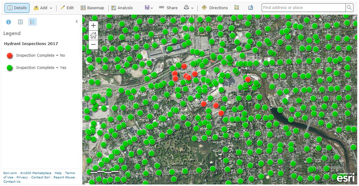
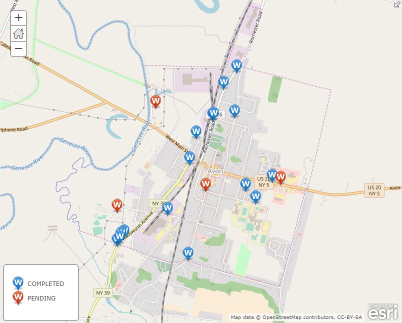
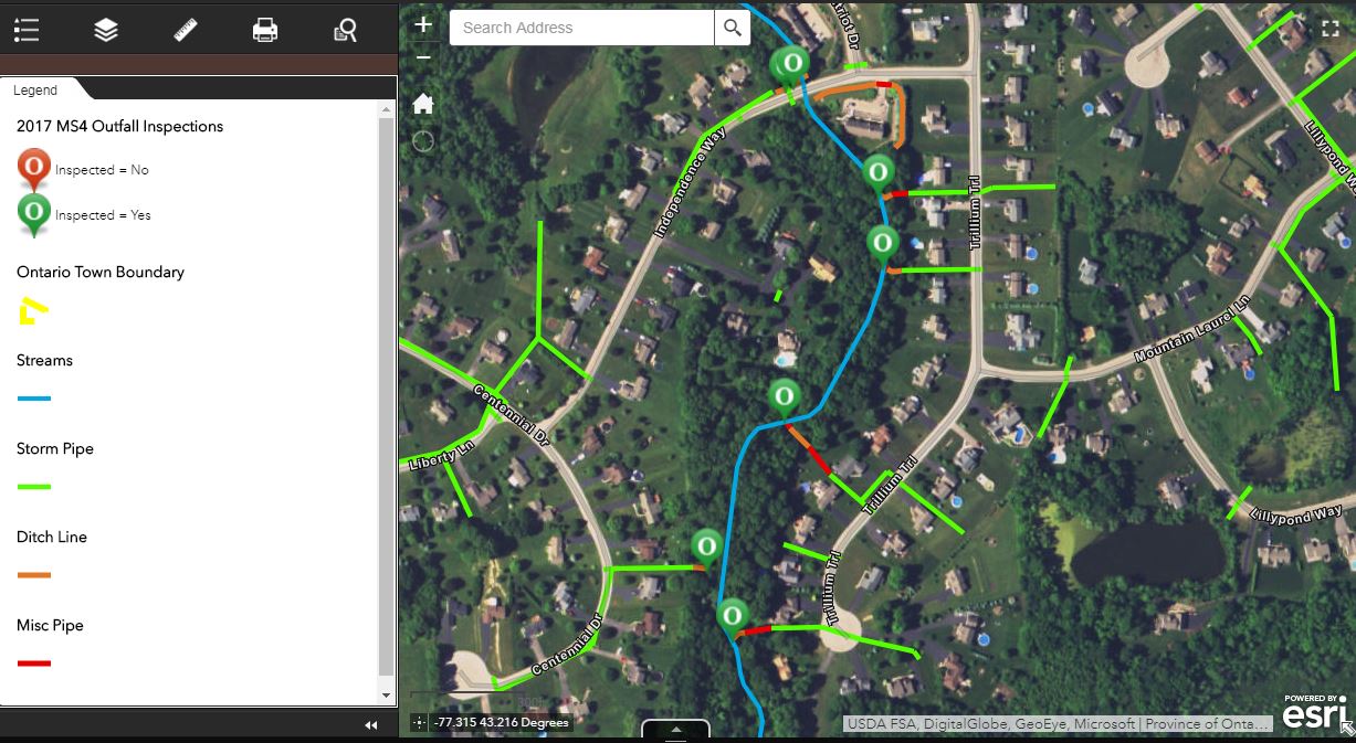
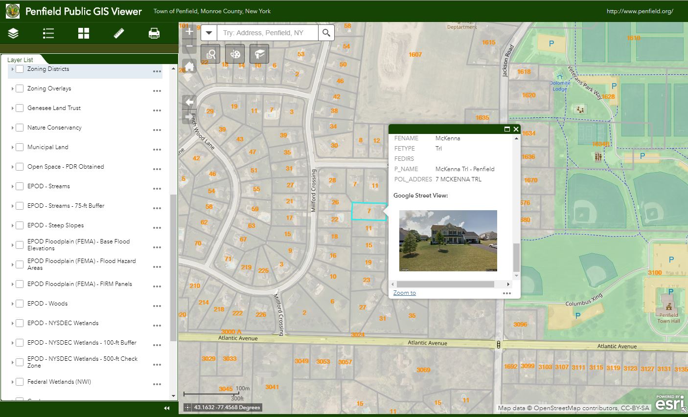
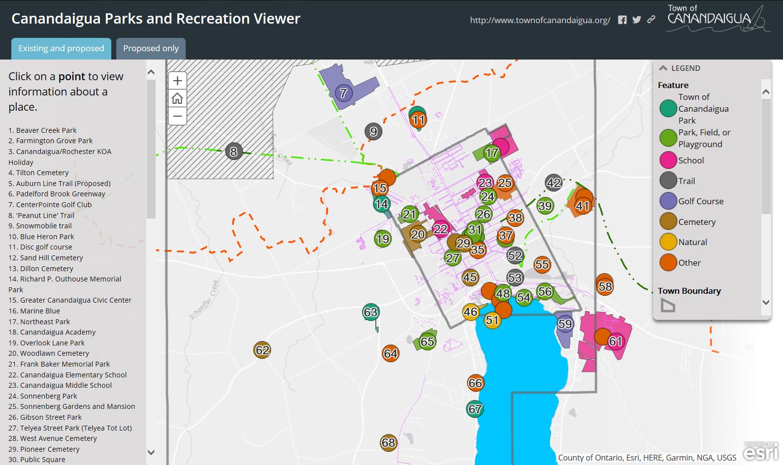
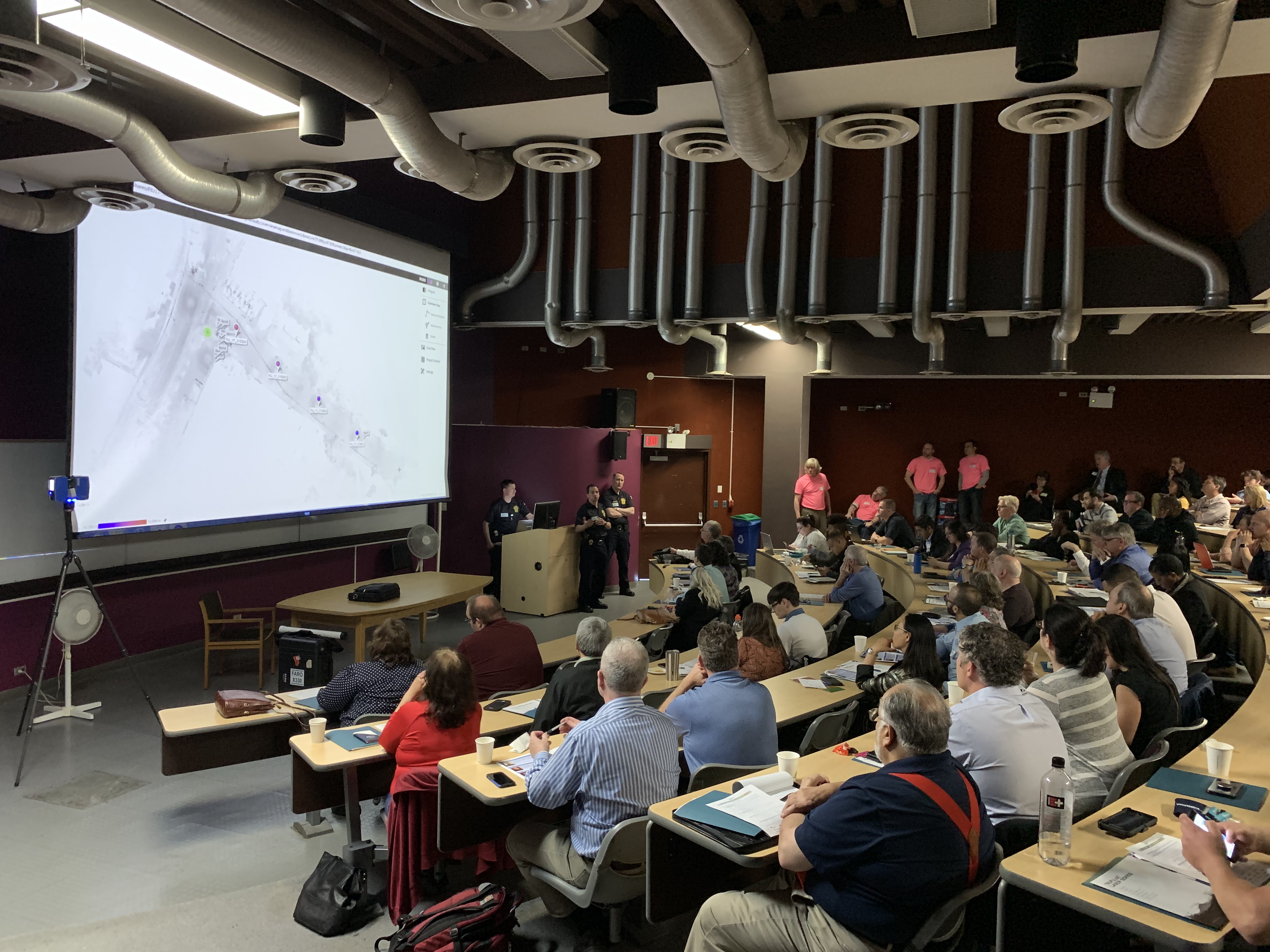
For many New York State local governments, GIS is not just a flashy map or application. It is a tool to manage vital records focusing on real property, development, and infrastructure.

MRB Group has been helping local governments implement GIS solutions for almost two decades.  Across the Empire State and learning from the experience in working with over 120 communities, MRB professional staff understand that the help of a GIS consultant can often be the difference between GIS becoming an indispensable management and decision-making tool versus a burden on staff.

The GIS team at MRB Group works alongside in-house engineers, architects, and planners to turn completed utility construction projects into permanent records in an enterprise and sustainable GIS program.   Once automated, local government managers can track the age, maintenance, and condition of utility infrastructure assets. Recent geospatial focus has been assisting local governments in leveraging smart device (phone) technology and expanding mobile GIS applications.  Municipal workers achieve a high level of efficiency when given the ability to view utility and assets on these devices and create/track inspections and work history in the field or in the office.   Additional MRB Group geospatial services include, tax map maintenance, ArcGIS.com account administration, contracted GIS support services, pavement management, EPA Municipal Separate Storm Water Systems (MS4) compliance, fire department pre-plan mapping, comprehensive plan mapping, and integration of survey GPS, 3D laser scanning, and unmanned aerial vehicle (UAV) and drone technologies.

Products and Services

City of Auburn

The City of Auburn is using the ArcGIS Collector app on Apple iPads to send multiple crews in the field for annual inspection and testing of 1,200 fire hydrants. The Fire Chief uses a desktop map viewer built with ArcGIS Web AppBuilder to monitor the status of field crews. When each inspection is finished, the hydrant symbol changes color on the map to indicate to all crews and the Fire Chief of its completion. (Figures 1 & 2).

Figure 1:  MRB ArcGIS Collector apps support fire hydrant inspection in City of Aubur

Figure 2:  Auburn fire hydrant inspections being conducted by fire department personnel.

Village of Avon

The Village of Avon is using the ArcGIS Collector app on mobile devices to actively mark and track the location of water pipe leaks and breaks. Over time, this will provide village officials with critical information to spot trends and to plan for necessary capital project improvements. The application also enables staff to enter notes about the repairs completed and attach pictures (Figure 3).

Figure 3: Village of Avon uses a MRB mobile app to assist in managing water system infrastructure assets.

Town of Ontario

The Town of Ontario was an early adopter of mobile GIS technology for managing its MS4 storm outfall inspections. Since 2013, the town has used the ArcGIS Collector app to visit each of the Town’s outfalls to monitor for illicit discharges, verify structural condition, and note maintenance requirements (Figure 4).

Figure 4:  The Town of Ontario deploys MRB developed apps to support MS4 regulatory programs.

Town of Penfield

Having seen significant growth in recent years, the Town of Penfield contracted with MRB to build a web and mobile-friendly application which would provide a public-facing GIS viewer for residents, businesses, and developers. The viewer includes information relating to zoning districts, agricultural districts, environmental protection areas, and purchased development rights, among other spatial datasets (Figure 5).

Figure 5: MRB develops apps for publishing geospatial data for the general public, business, and developers

Town of Canandaigua

The Town of Canandaigua is in the process of completing a Parks and Recreation Master Plan. An ESRI Story Map template was selected to create a GIS map of all the parks and recreation opportunities in the City and Town of Canandaigua. The application enables residents to click on points of interest on the map, see facility information, and generate driving directions.

MRB web apps create easy-to-use web viewers for identifying local government parks and recreation facilities

Summary

With a principal focus on municipal services, MRB Group provides local governments with professional engineering support for day-to-day operations focusing on water and wastewater treatment, and public works services. The GIS team at MRB Group is committed to creating solutions to help implement modern mapping technology into an understandable and useful tool for municipal workers across the Empire State.

For more information on MRB Group geospatial products and services:

Contact:
                             
Daniel Allen, GISP
MRB Group
585-381-9250
dallen@mrbgroup.com


GPS Telematics for Fleet and Mobile Workforce Management

Several of my posts over past 18 months have focused on a core set of applications which I have seen evolve over the past three decades that serve as the cornerstones for many New York State local and county government geospatial programs.  Increasingly and central to many of these geospatial program areas is the “mobile” component albeit much of the attention to date has been on “field/handheld” hardware and software components for both spatial data collection and updates.

Increasingly  it is becoming recognized  another mobile collection technology can add value to  an organization’s work force and business systems productivity.  Originally referred to as Automated Vehicle Locator (AVL) systems, this technology got its start decades ago focusing on the capture (mapping) of a vehicle’s location and display in a GIS or similar digital mapping system. These early systems were expensive and not widely used outside of business and industry.

Over the last five or more years,  fleet managers have increasingly adopted “AVL” technology to assist in the management of  fleet assets especially with availability of lower cost hardware components which connect  to vehicle On Board Diagnostic (OBD) ports.  This capability supports fleet managers with a wide range of metrics  providing  odometer/mileage readings, engine idling, vehicle usage and a variety of other vehicle related information.  Now recognized as “GPS Telematics”, this technology has become more affordable and accessible to a larger range of government agencies and organizations.  This modern use of the technology centers around the use of M2M (machine to machine) and telematics technologies.

Benefits of GPS Telematics

To date, much of the work focusing on capturing and analyzing data associated with field resources has been done the “old way”, i.e., capturing and recording the data by human fingers.  Historically, this method is fraught with inconsistencies. Machine-to-machine (M2M) data capture on average is far more accurate and consistent.

Fleet telematics monitor the location, movement, status and behavior of a vehicle and associated field resources.  This is achieved through a combination of the  GPS telematics device which is installed in each vehicle transmitting  location based data via wireless networks to web servers for near real time availability.  Users access location, movement and status information and metrics of vehicles via special web-based software applications or through existing in-house “vehicle tracking enabled”  business applications.  In essence, GPS telematics systems become platforms to collection and transport valuable mobile resource field information and activities.  In addition to locational data,  fleet telematics solutions provide the status of each vehicle and by extension the corresponding crew an inference of  ongoing work accomplishments and assignments to field resources.  Managers know how each vehicle is being used as well as mileage, idling status, location and speed.  Such systems can be extended to be connected to onboard systems and sensors which log activities such as street sweeping, plowing, spreading, and spraying – workflows which are particularly challenging to capture and document by hand during the normal course of business.  While Return-on-Investments (ROI) can and will vary greatly, calculating the benefits of investing in fleet telematics technology can now be  based on factual metrics such as improved routing and dispatching, reducing labor costs, improved fuel and vehicle usage, and newer more cost-effective system architecture (Cloud). Continue reading

2017 NYS Spring GIS Conference Specials

The last couple weeks I’ve been engaged in the following cutting-edge enterprise geospatial issues:  (1) staring at the sky on a daily basis,  (2) monitoring the temperature, and (3)  hoping the remaining snow to melt and the leaves to hold off in budding – both at the same time.  After nearly 33 years in County government and its boiled down to this! Why?  So we can get our aerial photography flown over the next 10-days to support our 2017 countywide base map update.  The heavy snow March 14th really set us back and the window to capture the photography is closing quickly.

So at any rate, its been easy to lose track of upcoming Spring 2017 regional one-day GIS conferences and meetings over the next 4-6 weeks.  Most of the Spring 2017 shows are held in locations accessible via a maximum 2-4 hour drive from furthermost parts of the Empire State, offer a wide range of geospatial topics and presentations, provide excellent networking opportunities among colleagues and industry representatives, and are generally light on the wallet.    For those unable to make or justify the big lift of getting to the uber ESRI conference in San Diego later on in the summer and/or chasing GISP certification credits these venues are for you.

Sounds sweet, right? So consider the following and get your travel approvals in order:

GIS-SIG 26rd Annual Conference, April 11th, Burgundy Basin, Pittsford, NY.  Unfortunately I cannot make GIS-SIG this year as it is one of my most favorite statewide one-day shows.  GIS/SIG provides the premier geospatial professional forum in the Rochester/Genesee Finger Lakes/Western New York region for GIS practitioners focusing on trends and policies relating to new geospatial technologies and current projects.  With a loyal following, the size and content of the GIS/SIG conference is broad enough to often substitute as an annual state conference for many GIS practitioners in the western half of the state. This year’s conference again includes vendor displays and an agenda covering topics such as mobile data collection, drones, 3D GIS, and ESRI software updates, as well as a keynote address from Dr. John R. Schott, founder of the Digital Imaging and Remote Sensing Lab at the Rochester Institute of Technology (RIT).  Corporate sponsorship keeps the price tag of an individual registration at under $100 for the day which also includes lunch. Online registration is still available and while you are at the GIS/SIG website you can also see the many resources and links GIS/SIG provides to its user community.  This is a great show and if you have the opportunity to attend. Highly recommended.

Long Island GIS (LIGIS)  2017 Spring User Conference, April 26th, SUNY Farmingdale, Farmingdale, NY.  LIGIS meetings and conferences have grown in structure and content over the last few years and this spring’s April 26th meeting will continue to illustrate the improvement among the Long Island GIS stakeholder user community.  Scheduled presentations from government, academia, and industry are on the agenda including topics covering mobile applications, MS4 data collection, 2020 Census Bureau update, and GIS & hydrofracking among others. Located in central Long Island on the SUNY Farmingdale campus, this is a not-to-miss conference on “the Island” for those with limited travel budgets.  Make plans to attend.  Those interested in attending can monitor conference specifics at the LIGIS homepage.

Northeast Arc User Group (NEARC) Meeting, May 15th, University of Massachusetts, Amherst, MA.  Spring NEARC meetings are conveniently located in Amherst, MA which is easily accessible to the Albany Capital District and GIS professionals in eastern New York State.  Unlike GIS – SIG, which is software vendor independent, this show is very much ESRI centric and packed with high quality user presentations. Even though only one day, the show has grown to be so popular that it now competes with the larger multi-day GIS shows and conferences across New England.   Price tag for attending:  $65 which includes lunch.  If you can afford an overnight, activities the evening before downtown Amherst and a hotel room at the UMass conference center make it even more worth your while. (As of the day of this blog post 4/4 the May 15th agenda was still in development; I did submit an abstract!).  Registration will open mid-April.  If your organization is an ESRI shop – this is a Spring show not to miss.

Westchester GIS User Group Meeting, May 11th, Purchase College, Purchase New York. As one of the largest geospatial meetings in New York State, the Westchester GIS User Group Meeting is a free one-day conference held at Purchase College. Made possible by financial support from exhibiting vendors and conference facilities provided by the college, the draft 2017 agenda  features user presentations from County government,  Westchester County municipalities, nonprofits including the Goodlands Project, and ESRI. There is also free conference training: At lunch “Leveraging Suvey123 for Mobile Data Collection” with instructor Larry Spraker and post-conference “Getting Started with How to Build Great Web Apps” with ESRI’s Mark Scott.   Also, sponsors get to present 5-minute “Lightning” talks over the course of the day.  The Purchase College location provides easy one-day access across the metropolitan NYC area, as well as the broader lower Hudson River Valley and southeastern Connecticut. Agenda and other meeting  specifics – including registration – are available from the Westchester County GIS website.

Other Venues:  If you are in the Metro NYC area don’t forget to check the GeoNYC Meetup calendar for ongoing meetings across the city. Subject matter and participation is pretty amazing.  And/or the many other geospatial related Meetups in the region covering big data, data visualization, agriculture mapping, and everything inbetween including drones. A little further removed geographically from the Empire State is the Northeast Geographic Information Society (NEGIS) conference on April 27th in Ashland, MA. You can follow and learn more about NEGIS via their blog.

The entire Empire State GIS community is fortunate enough to be close enough to a range of regional geospatial meetings and conferences which are accessible from most areas of the state and provide many of the same benefits of larger shows and not nearly as expensive.

Safe travels!

GIS Common Core Part 3: Health and Human Services (HHS)

Through a sequence of articles posted in eSpatiallyNewYork, I have proposed a series of GIS applications which provide a framework for establishing and maintaining  GIS/geospatial programs in local  governments (villages, towns, cities, and counties) across  New York State.  These applications areas are referred to as the Geospatial Common Core, many of which are integrated with local government office and administrative business systems.  Others are utilized in the support of regulatory reporting programs.    Together, the Geospatial Common Core contribute towards building sustainable geospatial capacity for local governments.   This is the third installment of the series.

“GIS Common Core” application areas in New York State local governments

The first article entitled Part 1:  Infrastructure and Asset Management focused on the growing and critical role local government GIS geospatial programs continue to serve in rehabilitating and maintaining the decaying and outdated New York State – and national – public infrastructure.  The second article Part 2:  Work Orders, Permitting, and Inspections (WOPI) published in March 2016 focused on geocentric software packages which are ubiquitous in government programs supporting work flows in areas such public works, health, planning, clerk, assessment, buildings/code enforcement and inspections.  Organizations investing and integrating WOPI systems with GIS will continue to help build long-term sustainable geospatial programs in local governments.

Part 3:  Health and Human Services (HHS)

Health and human services can often be broadly defined from one location to another but for the purposes of this article it includes a wide-range of government programs including, but limited to, public health services, social services, public assistance, youth and veterans programs, disability programs, housing and homeless services, child protection services, as well as the important network of contracted service providers governments rely upon in providing counseling and related support services.  I have long been an advocate of building geospatial capacity in these local government program areas.

Why?

Statewide local government HHS budgets typically dwarf other local government operational program areas with regard to annual appropriations.  While I am not a budget analyst and admittedly it’s sometimes difficult to follow the money trail of appropriations vs. revenues vs. actual tax payer costs in county budgets, here are a few examples to illustrate the size and magnitude of HHS programs in a selected 2017 NYS county budgets (Data/information from County webpages as noted):

  1. Stuben County 2017 Budget. (Page 3).  Pie chart indicates nearly 47% of the appropriated budget dedicated to Health and  Economic Assistance/Opportunity (includes Social Service disciplines) program areas
  2. Ulster County 2017 Budget. (Pages 1 & 2). Table and pie chart indicate nearly 42% of the appropriated budget dedicated to Public Health and Economic Assistance/Opportunity program areas
  3. Erie County 2017 Budget. (Pages 93, 159, and 174). Appropriations (rounded in millions) in Health ($86M), Mental Health ($47M) and Social Services ($591M) account for almost 50% of the $1,455,000,000 recommended general fund budget.  (Note:  There are other references to the 2017 budget being closer to $1.7B). Either way, HHS budgets are a significant portion of the overall county budget
  4. Albany County 2017 Budget. (Page 34). Employee Count table lists 657 of 2,535 County employees (26%) are in the Child, Youth, and Family Services (170), Social Services (308), Mental Health (90), and Dept. of Health (89)
  5. Suffolk County 2017 Budget. (Pages 101 and 366).   Appropriations (rounded in millions) in Health Services ($249M) and Social Services ($628M) account for nearly 30% of a recommended $2.9B budget
  6. Monroe County 2017 Budget. (Pages 157 and 275).  Appropriations (rounded in millions) in Human Services ($536M) and Public Health ($62M) account for nearly 50% of an adopted $1.2B budget
  7. Continue reading