Qntfii & Harkin Work Together to Provide Reality Capture Services and Education to the New York State Geospatial Community

The two New York State-based firms focus on drone and Lidar technology including SLAM (Simultaneous Localization and Mapping) applications.

The growth of UAV technology in New York State – particularly the Central New York (CNY) corridor is well documented and has the subject of eSpatiallyNewYork blog articles over the past couple years.  The region is home to a recognized UAV start-up incubator and there have been several news and market analysis articles covering the staggering growth of the industry, including a recent one (sample article available upon request) from Newswires

Two New York State firms in this space doing business together, albeit on the outskirts of the CYN region – one in Albany and the other Long Island:  Qntfill and Harkin.

History

The two initially crossed paths a couple years ago when tasked together on a Metropolitan Transportation Authority (MTA) project to map telecom infrastructure within the subway tunnels. However, the project was unfortunately scrapped before the two firms got to doing any actual (drone/laser/what kind) scanning – but it did serve as an introduction to each other’s services and laid the groundwork for many future collaborative efforts. 

Bill Gutelius is the principal at Qntfii who began his journey in the field of reality capture more than 25 years ago.  He transitioned from working with environmental engineering companies to working directly with the manufacturers of LIDAR equipment which at the time was a very emergent remote sensing technology.  He has founded a couple of startup business focused on LiDAR tools for reality capture, most recently starting Qntfi in 2014.  Qntfi is currently partnered with Emesent out of Brisbane Australia, the makers of the Hovermap SLAM LiDAR scanning tool.  Qntfii is an authorized Hovermap LiDAR sensing technology distributor.

Educated as an engineer, Scott Harrigan has served as President of Harkin Aerial since 2016 specializing in data visualization services to engineering, construction, and architectural clients, as well as custom engineered aerial solutions for a variety of industries.   His career path also included serving as a Product Specialist at Virtual Surveyor supporting clients on workflows to create quality CAD data from drone mapping.  He also served as Assistant Director of Long Island Group’s (LIG) Unmanned Aircraft Systems program, overseeing training, recruitment, logistics, and continuing education in UAS technologies for Civil Air Patrol members on Long Island.

Hovermap offers revolutionary advantages to challenging above ground, underground and GPS-denied environments. Underground mines, tunnels, bridges, telecom and transmission towers and many more can now be mapped and inspected safely, without putting staff at risk.

The different, but similar, individual focus and expertise uniquely augments their mutual business development.    Qntfii primarily focuses on handheld/ground level laser scanning, including indoors while Harkin brings drone and aerial data capture to the business equation.  Harrigan also coordinates training and education services as part of their joint work. Even though areas seem uniquely distinct, their services overlap on many projects.  One of their shared goals is to introduce drone, photogrammetry + LIDAR technology in a way that is both easy and cost effective for small-to-medium AEC (Architecture, Engineering, Construction) firms, as well as municipalities at the local town/village level to adopt. 

Selected Projects

Downtown Troy
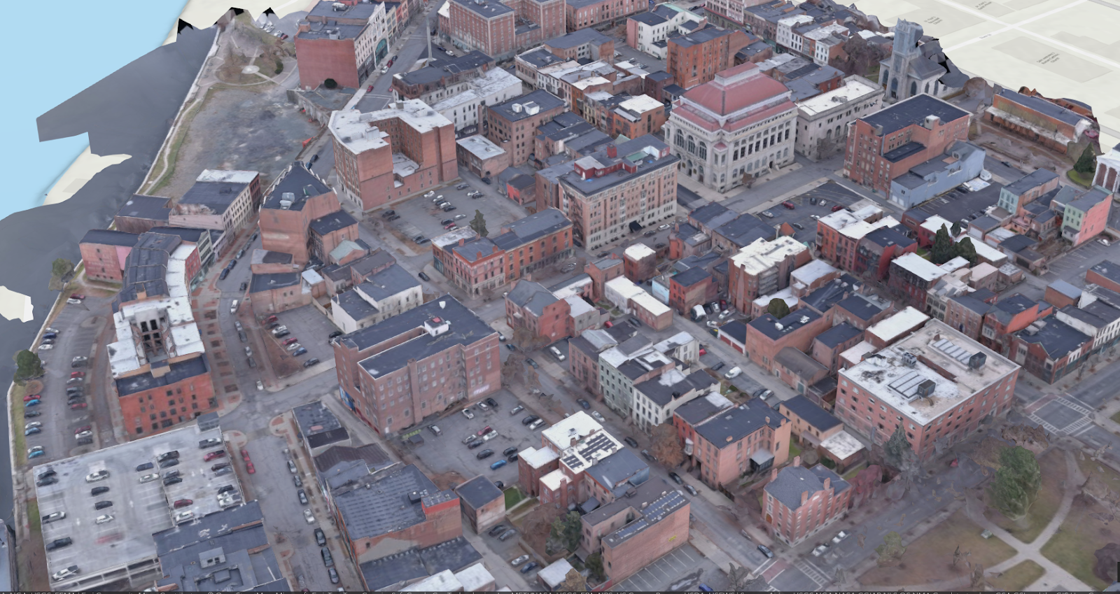
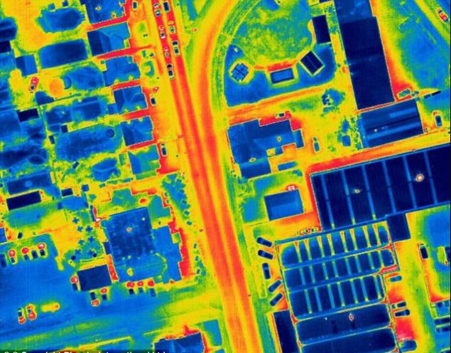
This was a proof-of-concept project employing a truck-mounted Hovermap to collect street level 3D data of a portion of downtown Troy, NY at 4 AM.  This work was then followed by a couple of short drone flights during the day to collect well-lit imagery that was then processed in a standard photogrammetric software package.  The two datasets were then merged to colorize the LiDAR data from Hovermap. 

Cohoes Power Plant
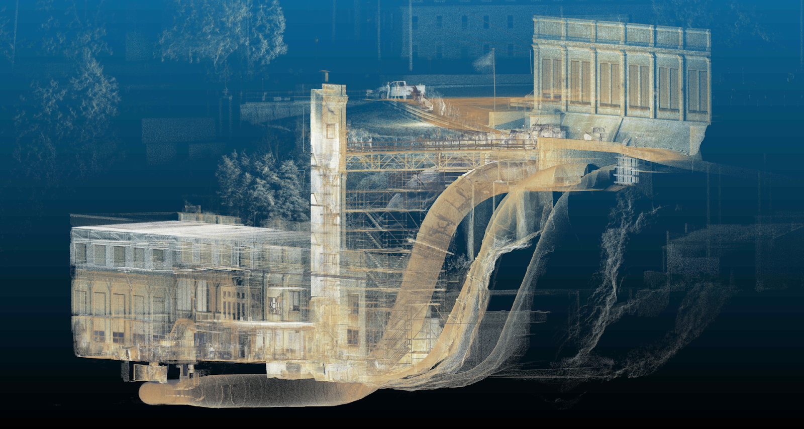
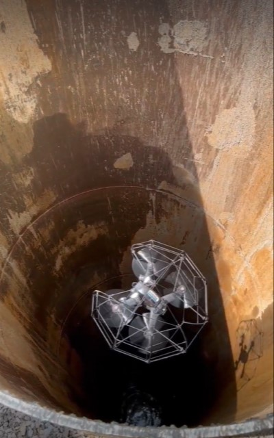
Power plant operators were  interested in documenting the entire site (including a penstock tube) using LIDAR.   Hovermap played a critical role obtaining 3D data of parts of the plant which would have been impossible or very costly to collect.  In one application, Qntfill and Harking were able to place the Hovermap (secured in a protective aluminum cage) through an insertion point in the penstock tube and then lower it 50-60 feet inside the tube, mapping the geometry and condition of the penstock interior. 

Site Development
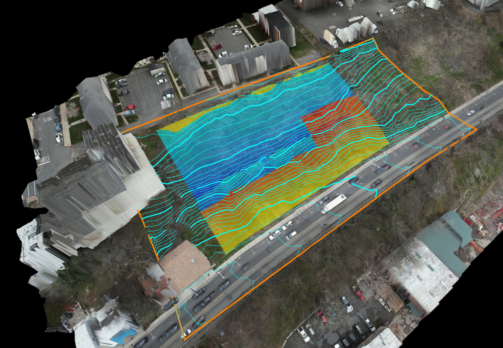
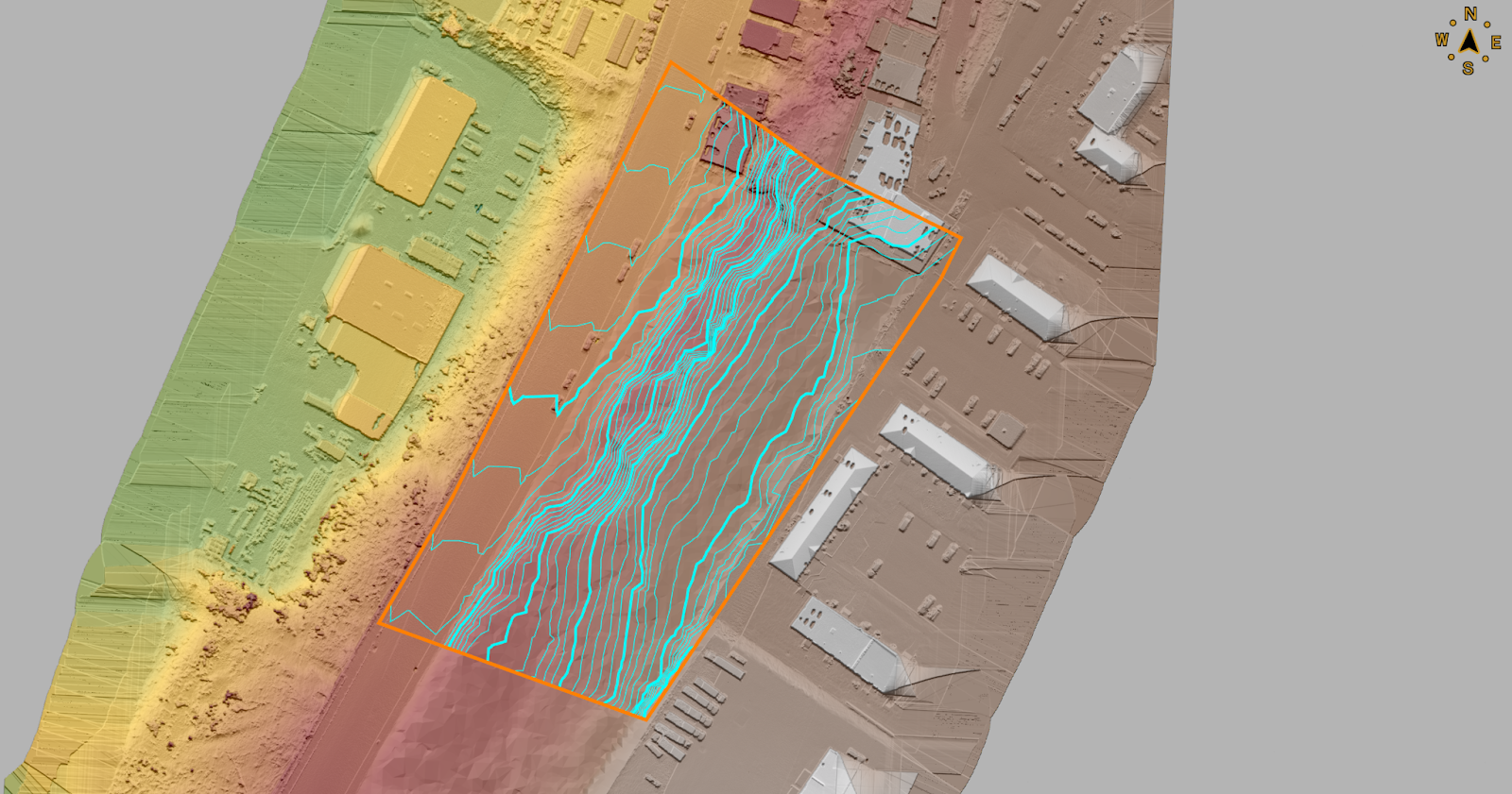
A DJI M300 drone with L1 LiDR was utilized by Harkin to produce bare-earth surface and contours for a new development in the Tri-State area.  Data was processed using DJI Terra (LiDAR) and Agisoft Metashape Photogrammetry software to provide up-to-date orthomosaics of the site.

By using the LIDAR-acquired surface, a 3D model was produced from excavation plans to determine the amount of cut and fill of earthwork required onsite.   The 3D model and volume calculations provided by Harkin allowed the site engineer to quickly adjust excavation plans to balance the earthwork onsite, greatly reducing the amount of trucks needed to bring in fill material, or take away excavated material. Cut/Fill calculations, contours, and surface were produced using Virtual Surveyor.  (Both images generated from Virtual Surveyor).

Harbors and Ports
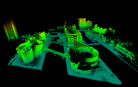
In the Baltimore Harbor, U.S. Navy and commercial port operators were interested in knowing the condition of port/pier infrastructure as very little existing documentation (as-built plans) were available for facility planning purposes.  Qntfii flew a Hovermap drone to identify available space for vessels and equipment, as well as to establish the general configuration of the port(s) and arrangement of vessels currently berthed in the harbor.

Additionally, the two firms have combined on a wide-range of projects in government and industry including, but not limited to, the following: NYC Department of Environmental Protection (NYCDEP), New York City Economic Development Corporation (NYCEDC), Village of New Paltz, NY, Town of Oyster Bay, NY,  U.S. Marine Corps, U.S. Naval Information Warfare Systems Command (NAVWAR), and The New York Times.

The drone market will most definitely continue to grow across the New York State, particularly as professional groups continue to come together and work together on common goals”, notes Harrigan who serves as Secretary for the NY chapter of AUVSI (Association for Unmanned Vehicle Systems International).  The chapter represents unmanned (drones, ROVs, robots) operators and businesses across the state and is probably the largest “drone” specific organization across the U.S.

Summary

“So much of this industry is geared towards “enterprise”,  big cities, and large – systems which requires a lot of manpower, IT, and intensive training to use. Our partnership focuses on bridging the gap to the small and mid-size organizations”, adds Harrigan.  

The two believe users don’t need to be large engineering/surveying firms or a state level department to have a successful drone and reality capture programs.  Both Gutelius and Harkin believe the best impact the UAV technology has is when it is working for smaller organizations.   

Contact

Bill Gutelius
Qntfill, Inc
1-518-406-0055
www.qntfii.co
info@qntfii.com

Scott Harrigan
Harkin Aerial
1-516-584-3035
www.harkin.io
info@harkin.io

Editor’s Note:  The 2024 IEEE Systems and Technologies for Remote Sensing Applications Through Unmanned Aerial Systems (STRATUS) is May 20-22, 2024 in Syracuse, New York

New York State Thruway Authority Drone Program Continues to Soar

Trained and certified operators work closely with state and local agencies in a myriad of data collection and inspection programs

Over the past three years, the New York State Thruway Authority‘s Unmanned Aircraft System (UAS) program has been expanding the application of drone technology across multiple areas of state governments. With support and encouragement from executive leadership coupled with dedicated staff in operations, the program has grown quickly and the benefits continue to be realized. The program is based on a commitment to safety, innovations, and increased government efficiencies.

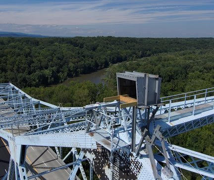
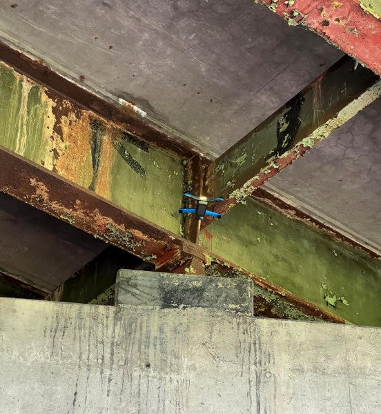
The use of drones reduces the cost and time of bridge inspections significantly. This image shows the Skydio S2+. Here is a great/short Skydio video on bridge inspections.

From Bridge Inspection to Bird Boxes: A Diverse Program

While the program began by exploring applications for UAS in bridge inspections, opportunities to apply the technology have grown agency-wide. Efforts by the UAS team in 2023 lead to a $1.5 million Strengthening Mobility and Revolutionizing
Transportation (SMART) Grant U.S. Department of Transportation as part of the Bipartisan Infrastructure Law, to update workflows and inspection procedures, and develop exciting capabilities like structural monitoring and digital 3D modeling.

Done missions in the last year has included the UAS team traversing the State of New York to inspect bridge mounted falcon boxes, searching for the presence of beaver in flooded areas, verifying the condition of rock in drill holes more than 40 feet deep for bridge piles, gathering data for corridor mapping along the right-of-ways, and covering commemorative events for media relations.

The drones offer a fast and safe way to survey locations of bird boxes located on Thruway bridges across the state. The process can be done without disrupting the birds versus having an inspector do the work. Using drones for the inspections is much more efficient and cost effective. This bird box is on the Castleton on Hudson Bridge outside of Albany.

Building a Skilled Team: Rigorous Training and Certification

The Thruway’s UAS team of FAA licensed, Part 107 pilots, which now exceeds a dozen, originate from a wide array of professional backgrounds including Land Survey, Environmental Planning, Traffic Management, and Highway Design. The program is currently refining the agency training program, while adhering to Federal, State, and local regulations, offering in-house practice opportunities, and live flight training across the system.  Additionally, the program benefits from the exceptional training programs supplied to state agencies by the NYS Department of Homeland Security. This includes equipping the team with advanced skills and knowledge from Part 107 Test Prep, Basic Flight Operations, Night-Flight Operations, Drone Thermography, and certification classes for Remote Pilot Proficiency Evaluation. With some of the T-pilots certified as Level 1 Thermographers, staff can utilize infrared cameras to analyze concrete and pavement as well as provide support for emergency services for search and rescue and Haz-Mat detection. The Thruway trains along with NYS Department of Environmental Conservation, NYS Troopers, County Sheriffs, and other first responders at the NYS Division of Homeland Security & Emergency Services mostly at the State Preparedness Training Center (SPTC) in Oriskany.

Drone cages have evolved to help protect device propellers in confined spaces, particularly inside structures and infrastructure systems. Here, the Thruway is using drones as part of the inspection process during the construction of bridge footings.

The team also works closely with representatives from Northeast UAS Airspace Integration Research Alliance (NUAIR). The not-for-profit drone research coalition provides subject matter experts as consultants to ensure that the program keeps up with evolving regulation, as well as testing and showcasing for new drone technologies.

Drone thermal imaging can also be used in a myriad of public safety applications including search and rescue operations.

Tech Exploration: Choosing the Right Tools for the Job

With more and more manufacturers entering the market, hardware options are becoming more specialized for individual tasks. And with the greater availability of hardware and technology options comes the increased scrutiny required to select the right tool for drone-related work. Much of the Thruway drone fleet consists of domestically produced, National Defense Authorization Act (NDAA) compliant aircraft, in conformance with the Buy American Act. The program also have a specialized drone designed for confined spaces with fully caged rotors and supplemental lighting added. Training drones are inexpensive, durable, in-door only drones that have no flight stability assistance or GPS which new pilots use to develop “stick skills” before progressing to live outdoor flights. The Thruway UAS pilots are always on the look out for the next aircraft which will improve efficiencies in data collection and continue to promote user safety.

Data Acquisition and Processing: After the Landing

While flight time in the field remains the most exciting draw to the program – it’s the data processing portion of the job where the real work is done. Just as hardware options expand, so does the software. As such, Thruway drone staff continue to explore various software platforms for mapping and modeling. Packages like Bentley’s iTwin, and Pix4D are currently in use while the team looks to expand knowledge of other options provided by companies like ESRI’s Site Scan for ArcGIS. The UAS team also continues to collaborate with the Thruway’s internal IT department and the GIS team to create effective data handling solutions for the large datasets created and associated with drone technology.

Summary

Upon creation of the program, the NYS Thruway Authority discovered a coalition of state agencies in New York and beyond which routinely gather and communicate to share experiences and knowledge about the UAS industry. All state agencies operating drone programs meet to train together and explore different aircraft and software platforms. Along the way building a team of drone experts which will promote safe and efficient inter-agency operations. NY State Fire, NY State Police, NYSDEC, NYSDOT, several county sheriffs, Metropolitan Transportation Authority (MTA), and many other agencies all work together to provide drone support state-wide. In doing so, benefiting from the collective experience and shortening the learning curve. “In addition to reducing costs in data collection and mapping efforts, drones offer new efficiencies and safety benefits to our organization”, notes UAS Department Director and Senior Surveyor, Andrew Kosiba, “Thruway staff continues to identify new uses and applications of the technology as our program branches out wider than we originally thought possible.

Contact:

Joel Kayser, PLS
Land Surveyor & UAS Remote Pilot
NYS Thruway Authority HQ
200 Southern Boulevard
Albany, NY, 12209
Joel.Kayser@thruway.ny.gov


10 Questions: ChatGPT for New York State GIS

I thought I was going to get out in front of all the ChatGPT for GIS discussion for the New York State GIS community, but that turned out to be off by a magnitude of sorts.  YouTube is already replete with ChatGPT for GIS tutorials and if we wait until next week there will probably be another ChatGPT alternative.  (I found the Matt Forrest YouTube video a good ChatGPT for GIS intro – actually formed a question after one of his examples).  Even Amazon jumped into the frey recently with their Amazon Bedrock option.  Take your pick, Bing Chat, Chatsonic, YouChat, Google Bard (available via a waiting list) and a whole host of others on the market in 2023. 

No, the robots aren’t taking over and I suspect we won’t see any of the early Terminator Cyberdyne Systems androids applying for your local GIS Analyst position anytime soon – though it might be a solution for those long dreadful digitizing jobs in the cart lab.  One way or another, Chatbot AI technology is definitely here to stay, evolve, and become another piece of the geospatial toolbox.  

Nothing specific or implied in any the questions.  Just random chains of thought though it does take a little getting used to putting the questions together vs. a basic Google search.  And it does seem to help to refresh and ask the same question twice – or even three times – to get more detailed results.  Never was a programmer, so a little short on questions in that space.

A lot here.  Actually 17 questions in all.  Straight copy and paste. Skim through as you want – find a topic/question you might be interested in.  There are tons more which could have been included.

Without any further adieu, my first machine interview: 

eSpatiallyNewYork:  What freshwater fish datasets are best for mapping fish population based on water depth in the Great Lakes?

ChatGPT:  There are several freshwater fish datasets that can be useful for mapping fish populations based on water depth in the Great Lakes. Here are a few options:

  1. Great Lakes Acoustic Telemetry Observation System (GLATOS) – This dataset provide information on the movements and behaviors of tagged fish in the Great Lakes.  It includes data on depth, temperature, and location, which can be used to create maps of fish populations based on water depth.
  2. Great Lakes Fishery Commission (GLFC) – The GLFC maintains a database of fish populations in the Great Lakes.  This dataset includes information on fish specifies, size, and location, which can be used to map fish population based on water depth.
  3. Great Lakes Environmental Database (GLENDA) – GLENDA is a comprehensive database of environmental data for the Great Lake region.  It includes information on water depth,  temperature, and environmental factors that can be used to map fish populations.
  4. USGS Great Lakes Science Center – The USGS Great Lakes Science Center conducts research on fish populations in the Great Lake and maintains a database of fish surveys.  This dataset includes information on fish species, abundance, and location which can be used to map fish populations based on water depth.

Ultimately, the best freshwater fish dataset for mapping fish populations based on water depth in the Great Lakes will depend on the specific research question and the type of analysis being conducted.

eSpatiallyNewYork:  To what degree of accuracy can I map features from New York State orthophotography?

ChatGPT:  The degree of accuracy with which you can map features from New York State orthophotography depends on various factors such as the resolution of the imagery, the accuracy of the ground control points used for georeferencing, and the skill and expertise of the analyst.

New York State orthophotography typically has a resolution ranging from 0.5 to 1 meter, which means that individual features such as buildings, roads, and other infrastructure can be identified and mapped with a reasonable level of accuracy. However, mapping smaller features such as individual trees, shrubs, or small structures may be more challenging, as these features may not be visible at this resolution.

The accuracy of mapping also depends on the quality of the georeferencing. The accuracy of the ground control points used for georeferencing should be of a similar or higher resolution than the orthophotography itself. This ensures that the imagery is correctly aligned with the ground, allowing for accurate measurements and mapping.

The skill and expertise of the analyst are also critical factors in the accuracy of mapping features from orthophotography. A trained analyst with experience in image interpretation and feature extraction techniques can accurately identify and map features with a high degree of accuracy.

Overall, mapping features from New York State orthophotography can provide a reasonable degree of accuracy for larger features such as buildings, roads, and other infrastructure. However, mapping smaller features may require higher resolution imagery or other sources of data. It is always important to validate and verify the accuracy of the mapping results through ground truthing and other quality control measures.

Continue reading

Summer Reading: The Drones Are Amongst Us

Transformation geospatial technology is emerging as a “must have” in government GIS programs

Last month Governor Kathy Hochul announced the completion of the Skydome facility at the Griffiss Business and Technology Park in Rome, Oneida County. Located in a former airplane hangar, the indoor facility is the largest indoor drone test facility in the nation and a major investment in New York’s Unmanned Aircraft Systems (UAS) Test Site.  This investment adds to the already impressive UAS and high-tech ecosystem in the Empire State centered along the Syracuse-Rome corridorIts no news at this point that UAS are a transformation technology in the GIS and geospatial space with cutting-edge research and development going on right here in our backyard.  The Northeast UAS Airspace Integration Research Alliance (NUAIR) website provides a great example of this growing technology space which includes government, industry and academia.

The governor’s announcement made me go back looking for my notes on the Systems and Technologies for Remote Sensing Applications Through Unmanned Aerial Systems (STRATUS) 2022 Conference held May  23-25 at SUNY ESF which I wanted to participate in and attend, but the scheduling didn’t work out.   The 2022 show was the fifth STATUS conference which brought together more than 100 professionals from across the United States and Canada.  New York’s geospatial community, including those from a host of academic institutions and local and state governments, was well represented in the nine technical sessions which included both oral and poster presentations covering topics including mapping and surveying, agriculture and forestry, flood and water quality monitoring efforts, hardware and software, and flights and operations. Great homegrown UAS research work coming out of Cornell, Rochester Institute of Technology, SUNY Binghamton, Hobart and William Smith College, and SUNY ESF.   One of the keynote speakers was Ken Stewart, Chief Executive Officer of NUAIR who I interviewed as part of a 10 Questions column last fall.  The STRATUS 2022 program guide, including abstracts and presentations can be found here

And for those coming out of college or those looking for a mid-career change – its a great job market.   If not a great job skill to augment any current geospatial position.    Commerical UAV News reports the top five drone pilot industry markets (in order) include:  mapping and modeling, thermal imaging, real estate photography and videography, inspections, and movies and television.  Another publication predicts that by the year 2025, at least 100,000 jobs will be created for drone pilots. (btw – while putting together this article, came across an update on New York State drone laws and regulations as of July 21, 2022).

Seemingly now present in every significant geospatial data collection effort at all levels of accuracy and need, drone usage will grow exponentially throughout government in the years ahead.  As governments continue to remain concerned over drone liability, privacy, and cybersecurity issues,  industry and consulting firms will continue to provide the bulk of drone and UAS operations.  This may change slowly over time, but the near future work will be supported largely by the non-government workforce.  One exception to this will be in the public safety arena where government staff will continue to be aggressively trained and licensed internally.   

In other areas it will be most likely specific drone consulting firms or engineering companies will step-in and provide drone/UAS services.  Many engineering companies have already  positioned themselves well in supporting government geospatial projects by building GIS capacity and offering a wide range of services skillsets – both on the desktop and in the field.  And drones are a perfect fit as part of their surveying and mapping consulting work particularly for smaller to mid-size governments with limited or no technical staff.      These same engineering firms now offering full service GIS programs including the managing of online products such as ArcGIS Online to data warehousing.  Particularly advantageous to local governments as datasets get larger and larger as the televising of infrastructure systems (sanitary, storm, potable water, etc), above ground 3D modeling, building information models (BIM), and high resolution imagery continue to be captured and developed in municipal governments.  Continued advancements by the major software companies such as ESRI and AutoCAD, and their business partners,  on the integration of drone generated data such as lidar only extends the ease of use and accessibility of drone/UAS technology for government organizations.

And with high accuracy mapping and surveying being one of the most common applications of drone/UAS use, particularly in context of the quality of imagery captured and increasingly larger geographic footprints of data being collected, might it lead to  the discussion as to how the emerging drone/UAS technology augments larger publicly – funded efforts such as the USGS 3D Elevation Program (3DEP)?  While the 3DEP program covers much larger geographic areas and is plane-based, is there a way to add smaller project areas which are drone/UAS  based and meeting appropriate federal lidar specifications to public data warehouses and inventories such as the U.S. Federal Mapping Coordination website?  Expand the State elevation library to include locally collected data?  There is so much elevation data being collected across the state by so many sources.

Summary

Government GIS/geospatial practitioners will do well to follow and participate in technology specific conferences and associations such as those represented at STRATUS 2022.  Many of which are becoming more accessible by being available online.   Industry specific conferences in engineering, public works, public safety – even agriculture – now serve as an excellent source of specific applied geospatial technology tools.  And drone/UAS technology is a common thread among them all. 

Coming to a geospatial application close to you soon. 

Hard Copy Maps Still Rule: NYS Agricultural Districts

The art form is still alive as counties design and create maps as part of the Agricultural District Certification process

I’ve written about agriculture in New York State before in context of the farming community continuing to evolve with the adoption of geospatial technologies. With farmland covering nearly 20% of the state’s geographic footprint, its easy to see why geospatial tools are so increasingly important in managing the state’s prime agricultural lands.  And one does not need to look far to see the advancements of new geospatial technologies in New York State agriculture, particularly with the recent Systems and Technologies for Remote Sensing Sensing Applications Through Unmanned Aerial Systems (STRATUS) conference May 23-25, 2022 at SUNY ESF in Syracuse. Several papers and even dedicated tracks of papers and presentations focusing on UAV/drone technology in agriculture.

And it’s big business, too. A November 2021 article published by NY Business Agribusiness Column: Economic Impact of Agriculture in New York State stated that “agriculture in New York State contributed $43.6 billion in total industry output, 160,100 jobs and $12.3 billion in gross domestic product across the state economy.” It’s a rather amazing article with many more figures on how agriculture impacts the statewide economy, The article is based on the work and research of Todd Schmidt, an associate professor with the Charles H. Dyson School of Applied Economics Management at Cornell University.

Which makes it all the more interesting in 2022, even with the fledgling agritech applications and the almost complete conversion and automation of our mapping, cartography, and business/financial systems, the certification of agricultural districts in the state still involves the use of an iconic piece of mapping and cartography: The hardcopy map. Yes, while the digital data/products in producing the hardcopy maps are used and repurposed in many useful and productive ways across the state, it is still the hardcopy map which is used as part of the agriculture district certification process by NYS Department of Agriculture and Markets (AgMkts).

Background

Since 1971 , the Agricultural Districts Law, Article 25AA of the Agriculture and Markets Law (AML), as administered through (AgMkts), has reflected state and county level efforts to preserve, protect and encourage the development and improvement of agricultural land for the production of food, fiber and other agricultural products. As districts are created, or modified during renewal, maps are generated, based on tax parcels included in the districts. Each county is responsible for creating maps to meet the requirements of the Agricultural Districts Mapping Program. Supporting AgMkts in this regard is Cornell University’s Institute for Resource Information Sciences (IRIS) has helped facilitate the mapping program since 1977. Its primary responsibility is to support agricultural district mapping efforts by reviewing, distributing, and archiving agricultural district maps, and to provide consultation services. Automation of the statewide district maps began in earnest In 1996 when the entire set of NYS Agricultural District maps in the collection of Cornell IRIS (formally CLEARS) was converted to digital format. This was done by shipping blueprint copies of the maps to the NYS DEC for scanning.

Article 25AA references maps several times in Section 303 as a required deliverable for certification of a district. Specifically the text includes “The district review plan shall include a description of the district, including a map delineating the exterior boundaries of the district which shall conform to tax parcel boundaries”Agricultural districts across New York State are reviewed and certified on an eight-year cycle.

The Map

It’s a real treat anymore to show up at a meeting or discussion and be given the chance to review a traditional, well designed hard copy map. Increasingly becoming rarer and rarer. And just think how much less demand there would be for hardcopy maps if it wasn’t for the ubiquitous use and sharing of the PDF file format? For so many years, the 1:24,000 map was one of the most commonly used map design and layouts following in step with the classic U.S. Geological Survey 2000-scale quadrangle grid series. And yes, it just so happens the required base map standard for the agricultural district maps, as outlined in the Agiriculture Districts Program Mapping Checklist prepared by IRIS, is 1:24,000. According to Diane Ayers, who provides staff support to the mapping program, “IRIS recommends either the NYS DOT 7 ½ minute planimetric map series (available in either raster or vector format) as the base map for individual County mapping products.

The 32-page document consists of written requirements covering topics such as, but not limited to, map content including roads, civil boundaries, and water features, as well as traditional map items such as north arrows, keys and legends, scale bars, and the bounding geographic coordinate grid.  Documentation on the source of base map data, other data layers, year of parcel data, and geographic reference information (datum, projection, etc) is also recommended.   It also includes several pages of examples covering a wide range of other hardcopy cartographic principles including annotation, color selection, and symbology.  Many items which cartographers and map makers have greater flexibility in controlling when using desktop client software vs. web mapping cartographic tools. 

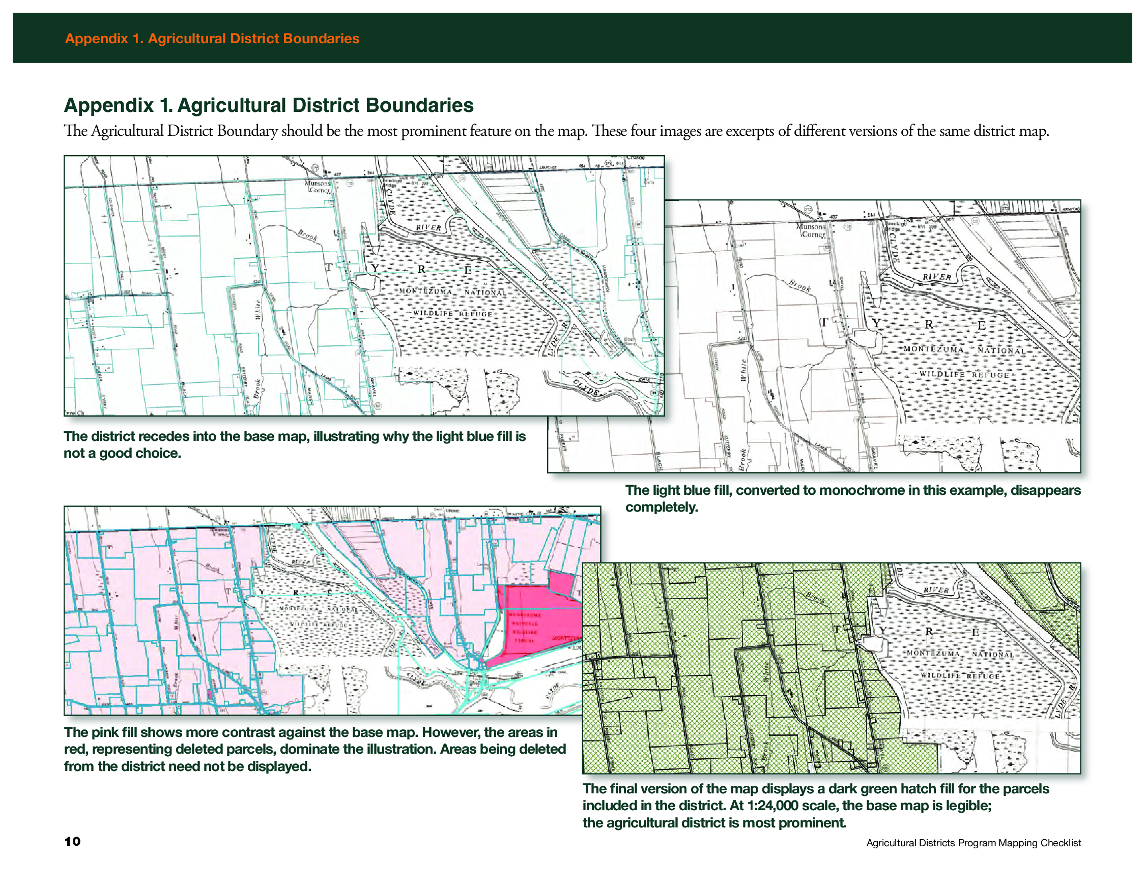
Appendix 1 in the Mapping Checklist document shows examples of how to render the district boundary as the most prominent feature on the map

While counties send all review materials associated with the eight-year review, including tax parcel information, directly to AgMkts, the county produced hardcopy map and shapefiles are sent directly to Ayers.   She reviews the maps for consistency with the mapping checklist and then forwards to AgMkts and uses the shapefiles to maintain a consistent a set of statewide district maps which are available via CUGIR.  The statewide coverage she maintains based on this relationship and data exchange with the counties can be found here.

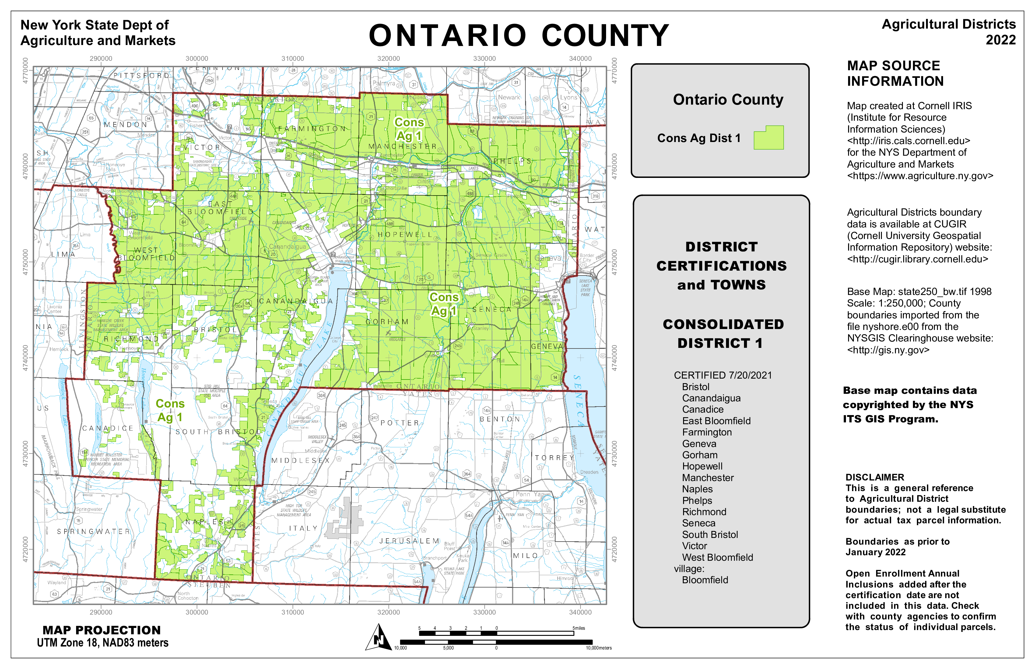
The 2022 Ontario Agriculture District Map as produced by IRIS. Shapefiles and documentation received from counties enables IRIS to maintain a statewide agricultural district coverage.

Sheri Norton is the GIS Coordinator for Ontario County, located in the Finger Lakes region renown for viticulture and other agricultural products. She has been through three district reviews including a large countywide consolidation in 2021. “Agriculture District mapping is a big effort with partnership between our Planning, Real Property and GIS Program staff”, she says, “but with my previous experience in producing the mapping products for IRIS and becoming more comfortable with ArcGIS Pro, the map series and formal reports are now easily updated for the next review cycles.  The ArcGIS client is all I use.”   Which is quite an accomplishment, as keep in mind many final cartographic products are often “touched up” before final publication with other desktop publishing software such as Adobe Illustrator. The certification also includes generating a list of all tax parcels in the district(s) based on the county assessment roll.

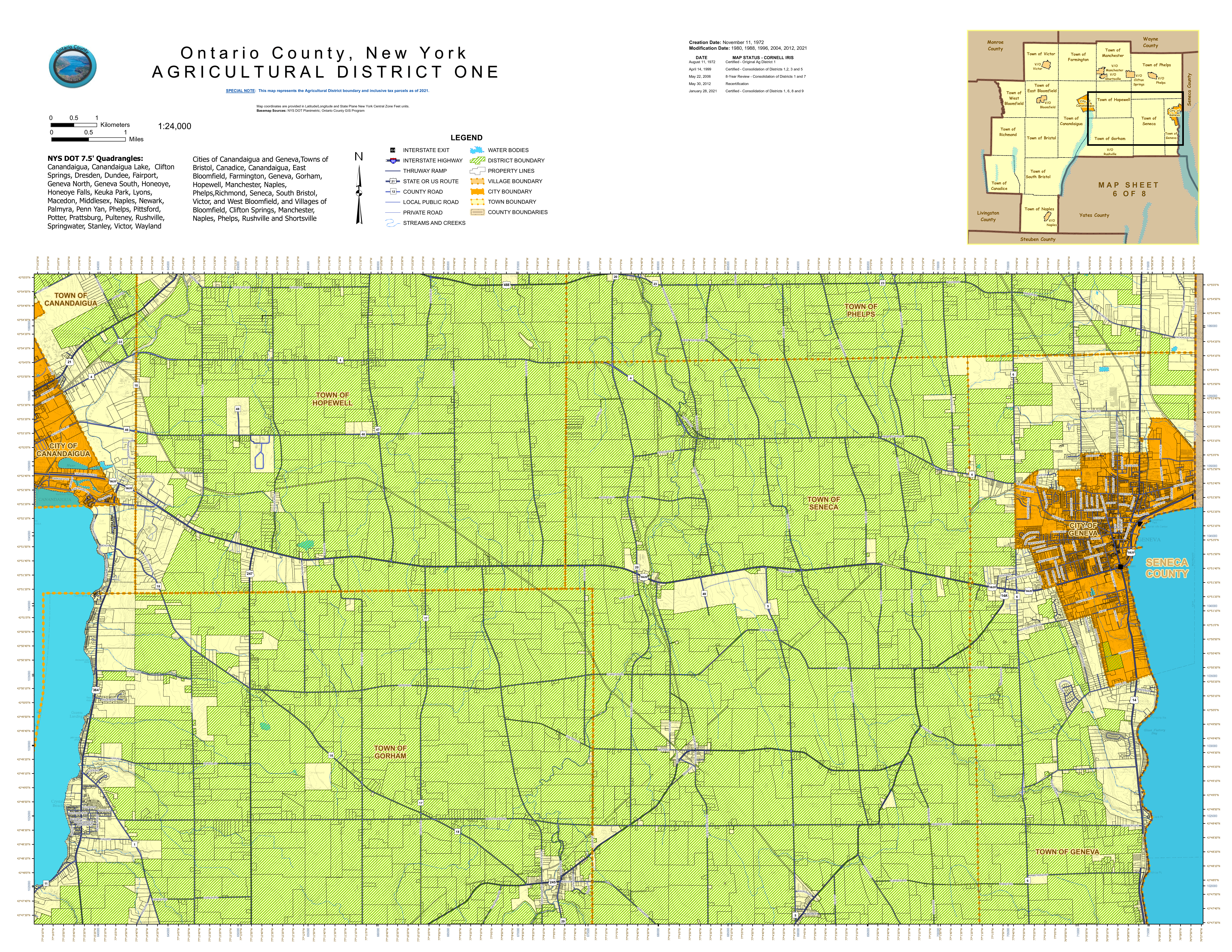
Sheri Norton’s 2021 Ontario County Agriculture District One map designed and produced entirely with desktop GIS software.  This same map was provided to AgMkts as part of the review and certification process

Summary

Hard copy maps are as close to GIS comfort food as we can get.   And here in New York is refreshing to see how this important piece of our cartography past is still being used in a government regulatory program.  Holding its own against all of the advancements – and acceptance of digital web mapping.  Kudos to GIS professionals across the state who are still producing hardcopy maps and helping the product remain relevant as part of the profession.

Agricultural Districts protect and promote the availability of land for farming purposes.  For informative overview of this important Empire State Program review this presentation.

Contact

Diane Ayers
Data Manager and Educator
NYS Agricultural Districts Mapping Program
Cornell IRIS
1015 Bradfield Hall
Ithaca, NY 14853
dag10@cornell.edu

Sheri Norton 
GIS Coordinator, GISP
Geographic Information Systems Program
Ontario County Information Technology Department
70 Ontario Street
Canandaigua, NY 14424
Sheri.Norton@ontariocountyny.gov

Jeff Kehoe 
Farmland Protection Specialist
Department of Agriculture and Markets | Division of Land and Water Resources
10B Airline Drive
Albany, New York 12235
jeffrey.kehoe@agriculture.ny.gov

Geospatial Business Spotlight: Maine Technical Source

NY Locations:     787 Old Sergeant Palmateer Way, Wappingers Falls NY
                              2634 James Street, Syracuse NY

Website:               www.mainetechnical.com 

Employees:          18

Established:         1973


The Company:

Maine Technical Source (MTS) sells, services, and supports high-end instrumentation for the geospatial industry as well as the surveying, engineering, and construction sectors throughout New England.  New York State offices are located at 787 Old Sergeant Palmateer Way in Wappingers Falls, & 2634 James Street in Syracuse. 

Gus MacDonald started the company over 45 years ago and more than half of the MTS employees have been with the company for more than fifteen years.  In June 2017, Stuart MacDonald purchased the company with a commitment to continuing the legacy of meeting customer needs.   Maine Technical Source employees are singularly focused on providing exemplary customer service.

MTS is a member of the New York State Association of Professional Land Surveyors (NYSAPLS).  

Products and Technology:

MTS provides a wide range of traditional industry products as well as state-of-the-art components now available in emerging and laser scanning technologies.  A complete listing of products can be found as part of the MTS online catalog.  

Illustrative products common to the geospatial, BIM and AEC applications include:

Field Mapping

Leica Zeno Mobile is a complete tool for high accuracy field data capture with the simplicity of an Android app.  Managing assets has never been easier via it’s intuitive user interface and functionality.  Users can export collected data to the PC as shape files, ASCII or KMZ, either in classic way via cable, USB or using the cloud with Dropbox. The app also comes pre-loaded with aerial imagery.  Learn more about Leica Zeno GIS technology via online training videos here.

UAV Solutions

MTS offers complete UAV solutions for the surveying, mapping and construction industries enabling fast and flexible data collection.  Systems capture, process and analyze millions of data points depicting highly accurate spatial information of the natural and built environment.   One of MTS’s more popular drone solutions is the DJI Phantom 4 RTK which is one the most compact and accurate low altitude mapping UAV devices. 

The Leica Aibot SX focuses on UAV data capture in the surveying geomapping, and asset  disciplines enabling users to create orthophotos, point clouds, and 3D models for cadastral survey and data collection. Leica Aibot CX focuses on UAV data capture in the construction industry providing up-to-date views over construction projects and earthmovings.  It also opens opportunities for daily progress documentation, stockpile monitoring and resource tracking to increase efficiency.

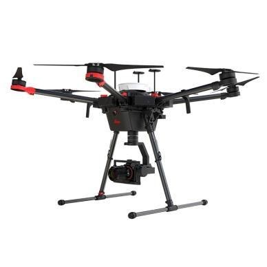
WingtraOne Gen II is a vertical take-off and landing (VTOL) sUAS for mapping of small and large areas.  It utilizes a high resolution Sony DSLR camera platform and post-processing kinematic(PPK) to provide precise geotagging of the images.  As a VTOL drone it can take off and land like a quad-copter and then transition into level flight as a fixed wing.  With the high-resolution camera it can fly missions higher and faster than a quadcopter with outstanding ground sampling distance (GSD) results.

MTS is a Pix4Dmapper reseller which is the the leading photogrammetry software for professional drone mapping.  Users can capture RGB, thermal, or multispectral images with any camera.  Pix4Dmapper’s photogrammetry algorithms transform  ground or aerial images in digital maps and 3D models. 


Field Tablets

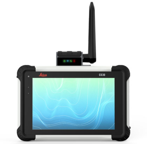
Leica CS30 Data Collector is the best of both worlds – light weight (1.67 lbs) and compact yet with a screen size (7”) big enough for use all day long.  Equipped with an LCD IPS screen to provide an optimal color clarity, as well as a much improved and increased viewing angle. The unit also has an ambient light sensor for improved visibility in all lighting conditions.  Portable to fit into a field bag or typical pickup truck glove box.  Other similar devices MTS offers include the Carlson RT4 and the Sokkia SHC6000

Laser Scanners

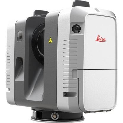
MTS focuses on providing and supporting Leica Systems laser scanning technology including the new highly portable RTC360.  Intuitive and designed for maximum productivity, this unit efficiently combines the RTC360 high-performance 3D laser scanner, a Leica Cyclone FIELD 360 mobile-device app or automatically registering scans in real time, and the Leica Cyclone REGISTER 360 office software.  Depending on the specific application area of use, MTS also offers HDS software for integration into the AutoCAD, Revit, and MicroStation platforms among others.  Here is a RTC360 video

For a complete listing of all MTS products, visit their website.  

Contact:

Stuart MacDonald, President smacdonald@mainetechnical.com
Bill Treadwell, GIS Sales btreadwell@mainetechnical.com
Brad Beeler, Wappingers Falls brad.beeler@mainetechnical.com
David Filipski, Syracuse dfilipski@mainetechnical.com

10 Questions: Ken Stewart, NUAIR

Northeast UAS Airspace Integration Research Alliance

Ken Stewart is currently Chief Executive Officer of NUAIR (Northeast UAS Airspace Integration Research Alliance, Inc.) located in Syracuse, New York.  NUAIR is a New York based nonprofit organization that provides expertise in unmanned aircraft systems (UAS) operations, aeronautical research, safety management and consulting services.   He joined the organization in late 2020 where he is responsible for setting the overall vision and product strategy for the organization.  Mr. Stewart is an experienced industry veteran in wireless telecommunications and cloud-based software market with a specialization in building Enterprise SaaS, Federated digital marketplaces and platforms.

Prior to joining NUAIR,  Mr. Stewart served as the CEO of AiRXOS, a General Electric aviation company, where he led innovation, development, and commercialization of Unmanned Traffic Management services.  After beginning his career in engineering and management positions at IBM and GTE, Stewart served as an executive with several venture capital and private equity-backed companies commercializing and scaling pre-revenue start-ups and transforming organizations for growth.

He was recently appointed president of the Commercial Drone Alliance (CDA) which is an independent nonprofit that works with all levels of government to collaborate on policies for industry growth and the overall responsible use of commercial drone technology.

I was recently able to catch up with Ken and NUAIR staff to discuss his work in the drone space in New York State.

eSpatiallyNewYork: What is the primary function and purpose of NUAIR?

Stewart:  NUAIR is responsible for the continued development and advancement of New York’s AAM Proving Grounds and 50-mile UAS corridor between Syracuse and Rome, facilitating beyond visual line of sight testing, commercial operations, and the safe integration of UAS and eVTOLS into the national airspace.  Here’s a link to some of the history of how everything got started: https://esd.ny.gov/central-ny-rising-uri

NUAIR also manages operations of the New York UAS Test Site at Griffiss International Airport in Rome, NY, one of just seven FAA-designated UAS test sites in the United States and is responsible to the Federal Aviation Administration (FAA) and National Aeronautics and Space Administration (NASA) to conduct operations for UAS and advanced air mobility (AAM) eVTOL (electric vertical takeoff and landing testing).

eSpatiallyNewYork:  NUAIR seems to be mostly New York State-based.  How does its function and purpose differ from CDA? 

Stewart:  We continue to conduct meaningful projects and tests in New York for the FAA, NASA, and industry to advance both the UAS and advanced air mobility (AAM) industries. These projects provide the needed data to prove the safety and reliability cases to help shape policy and regulation to unlock the true potential of commercial drone operations. I am taking my professional expertise, coupled with the knowledge of the 3,600+ UAS test flights NUAIR has conducted at the New York UAS Test Site to help generate the needed policies and regulations to make national commercial drone operations both scalable and economically viable. I also represent NUAIR on the FAA beyond visual line of sight (BVLOS) advisory and rulemaking committee (ARC), actively working with the FAA and fellow industry leaders to solve the issues around safely flying BVLOS. Being a part of both of these initiatives gives NUAIR the ability to directly influence and shape the future of aviation.

eSpatiallyNewYork:  Can you share some examples of NUAIR  providing outreach and consulting to governments in New York State on drone use and/or technology?

Stewart:  NUAIR has helped over 20 state agencies implement their drone programs including law enforcement, fire departments, environmental conservation and more. Selected examples are highlighted in this YouTube video.

We’ve also just started working with the New York State Thruway Authority, helping them integrate drones into their daily operations for routine bridge and infrastructure inspections. Flying a drone to scan a bridge is a lot safer than the traditional means of using a snooper truck, both for the crew inspecting the bridge and for motorists. Couple that with faster, more cost-effective inspections, it’s a win-win for the crew, the local economy and New York State as a whole.

eSpatiallyNewYork:  Would appear a lot of this work is in the public safety community.  Are there other areas of government?   

Stewart:  The healthcare industry is beginning to realize the benefits of utilizing drones as well, especially the ability of contactless delivery of materials. You can read here about one of our recent collaborations with SUNY Upstate Medical where we helped deliver unused COVID-19 Test Kits.

eSpatiallyNewYork:  Explain NUAIR’s relationship with the start-up incubators Genius NY and The Tech Garden. 

Stewart:  GENIUS NY and The Tech Garden are key partners and organizations for the Central New York UAS and high-tech ecosystem. We work directly with many of the companies in the Tech Garden and actively promote the resources both organizations provide to tech startups, actively contributing to the economic development of the region. Our COO Tony Basile is also on the board of directors for GENIUS NY, actively reviewing applicants and voting on the winners.

eSpatiallyNewYork:  The NUAIR Alliance is impressive.   How do these categories stack up in New York State? 

The NUAIR Alliance continues to grow on a global scale and includes organizations from all aspects involved with UAS and technology including policy & standards, spectrum, test sites, components, government and more. Visit https://nuair.org/alliance/ to see all of our active Alliance members.

NUAIR and the New York UAS Test Site has brought over 330 different companies from across the world and thousands of people to Central New York throughout the years and continue to bring in companies to test and setup shop.

eSpatiallyNewYork:  FAA, NASA Aviation, and state/local drone regulations – how does NUAIR stay on top of all the changes?  It all seems so fluid, dynamic, constantly changing.

Stewart:  This is what we do all-day, every-day. NUAIR employees are talking with, working with and/or conducting meaningful projects the FAA, NASA and industry every day of the week.

eSpatiallyNewYork:  How’s the industry dealing with all of the security concerns over Chinese made drone products such as the DJIs?  How are US-based companies responding in this regard?  

Stewart:  The concern with Chinese/foreign made drone and components continues to grow, including the recent regulations from the United States government stating that federal funds cannot be used to purchase Chinese (or other specific foreign countries) drone components. A lot of the public safety officials we work with are now looking into one of our partners, Skydio, an American drone manufacturer, who was a major hit at the New York Public Safety UAS Summit we just held. We’ve also validated a drone parachute on the WorkHorse, an American-made UAV built for deliveries.

eSpatiallyNewYork:  Any involvement / business development with the any GIS companies?

Stewart:  We have quite an active program with Cardinal Geospatial, trying to define an analysis tool that could be used to determine whether an operator was using a DEM with enough granularity for their mission and the terrain over which they are flying.

eSpatiallyNewYork:  Looking into the crystal ball, what’s the next big thing for the upstate drone/NUAIR community? 

Stewart:  5G. MITRE Engenuity Open Generation Consortium has determined New York’s 50-mile corridor is a prime location to launch the nation’s first 5G UAS testing range, a designation that will greatly enhance New York’s position as a global leader in this emerging technology sector.

The work we continue with the FAA, NASA, and industry both on the standards/regulations side and the physical data collection/testing side are helping shape the future of aviation. This work will unlock the true potential of drones for commercial operations that are both scalable and economically viable. The drone and overall high-tech Central New York ecosystem has everything a company needs to land and expand their UAS operations.

Contact:

Tim Lawton
Director of Marketing & Public Relations
tlawton@nuair.org
www.nuair.org

Geospatial Business Spotlight: Woodard & Curran

Location:                      Rye Brook, New York (Other Locations Nationwide)

Website:                       Rye Brook & Corporate

Employees:                 30 Rye Brook Office / 1,200 Nationwide

Established:                1979

The Company

Woodard & Curran is a privately held, national integrated engineering, science, and operations company. It was founded in 1979 by  Frank Woodard and Al Curran with a mission to provide a safe and enjoyable place to work with opportunity, integrity, and commitment, and to attract talented people. Woodard & Curran experts are devoted to their work which is reflected in exemplary project and program results for both public and private clients. Through a multidisciplinary approach, Woodard & Curran strives to solve clients’ technical and business problems, routinely finding unique and cost effective solutions for their clients.
Geospatial Software and Technologies:

A registered ESRI Business Partner, Woodard and Curran’s geospatial team offers the following services:

  • Needs Assessment & Implementation Planning
  • ArcGIS Online (AGOL) Configuration & Management
  • ArcGIS Enterprise Planning & Implementation
  • Paper to Digital Conversion
  • Data Standards Development
  • Field Data Collection
  • Data Integration
  • Database Design & Administration
  • Map Production
  • Web GIS Development
  • Mobile Application Development
  • Asset Management Planning and Implementation
  • Computerized Maintenance Management System (CMMS) Integration
  • GIS and GPS Training

Geospatial Products and Services:

Woodard & Curran’s geographic information system (GIS) experts leverage the latest technologies to transform outdated data management processes into practical, efficient, and effective solutions for public and private clients. As a registered ESRI Business Partner, Woodard & Curran uses ArcGIS Online’s powerful platform to optimize spatial data through web maps and workflow specific applications for internal or public use. Woodard & Curran customized ESRI’s ArcGIS Online and Portal environments  provide clients with secure permission-based access for individual users to view, edit, or analyze data. Specific geospatial programs supported include:

ArcGIS Online Jumpstart Program

Focusing on the ArcGIS Online framework, Woodard & Curran provides customized, certified GIS professional assistance to organizations getting started with AGOL by offering:

    • Initial setup and configuration of an ArcGIS Online environment;
    • Prioritizing web maps and applications;
    • Instructions on setup, configuration, and use of web maps and applications;
    • Ongoing training for those responsible for managing AGOL environment

 GIS Enterprise Solutions

Woodard & Curran offers professional services for the full suite of ESRI ArcGIS products including ArcGIS Desktop, ArcGIS Enterprise, and ArcGIS Online along with extensions and add-ons. Such client services are offered on premise or remotely depending on the nature of the GIS professional services being provided. This work includes support for GIS needs assessments, data conversion & migration, and design & implementation of new GIS environments for clients just starting out with GIS. For clients with more mature GIS environments, Woodard & Curran professional staff also provide advanced GIS Strategy and Planning, System Integrations, or Advanced System Architecture and Design Services.

Field Data Collection Solutions

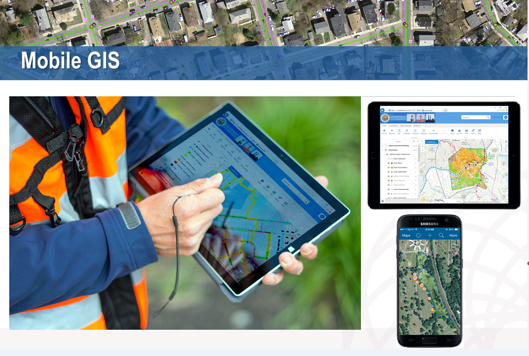
Woodard & Curran’s geospatial experts help clients identify, configure, and implement a variety of field and mobile data collection solutions.  Field data collection can include the inventory or field verification of assets using mobile technologies including smart phones, tablets, and Global Positioning System (GPS) devices. Depending on the needs of the project, information can be collected with varying degrees of location accuracy ranging from sub-meter to centimeter. Mobile data collection applications, such as ESRI Field Maps and Survey 123, and GPS solutions allow for accurate updates to be made in the field for real-time data management.

Mobile data collection is a “must-have” app for the engineering disciplines. Woodard & Curran designs and deploys a wide variety across many platforms.

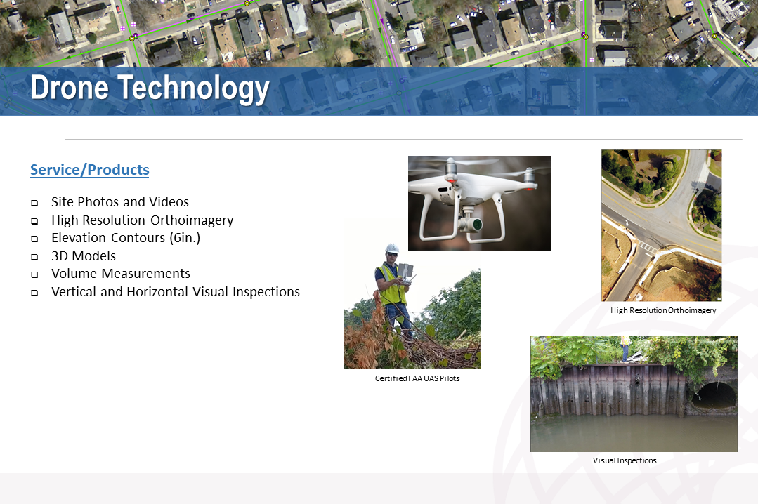
Woodard & Curran’s GIS experts also offer drone services to access terrain or infrastructure that may be too vast or pose safety concerns with numerous FAA certified small unmanned aircraft system (sUAS) and drone pilots.  Drones produce high resolution orthoimages, elevation contours, three-dimensional and land use analysis, volume measurements, planimetric maps, and vertical or horizontal visual measurements.

Woodard & Curran has FAA licensed UAS operators which help support many types of field data collection projects. Drones are increasingly being used to access sites which are either inaccessible or unsafe for field workers to get to.

Asset Management Technology

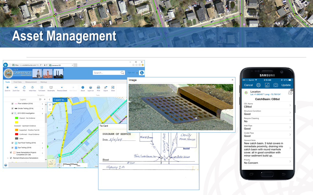
While asset management (AM) plans operate on a long-term vision, these plans rely on hundreds of daily dynamic inputs. And keeping track of these data points and life-cycle strategies requires a comprehensive AM technology program.

AM technology applications must be chosen carefully because they will store critical asset information, administer aspects of maintenance process and provide critical information to users when needed. These applications should fit both current and future needs, while providing the functionality necessary to maintain critical assets effectively. In supporting geospatial applications in this space, Woodard & Curran leverages business intelligence (BI) software, such as Microsoft PowerBI and ArcGIS Dashboards, to connect, integrate, analyze, and present business key performance indicator (KPI) data.

Woodard and Curran’s geospatial asset management strategy is integrated with organizational business programs such as Business Intelligence (BI) and Data Analytics and Enterprise Asset Management Systems (EAMS).

Testing Public Water Fountains for NYC Parks

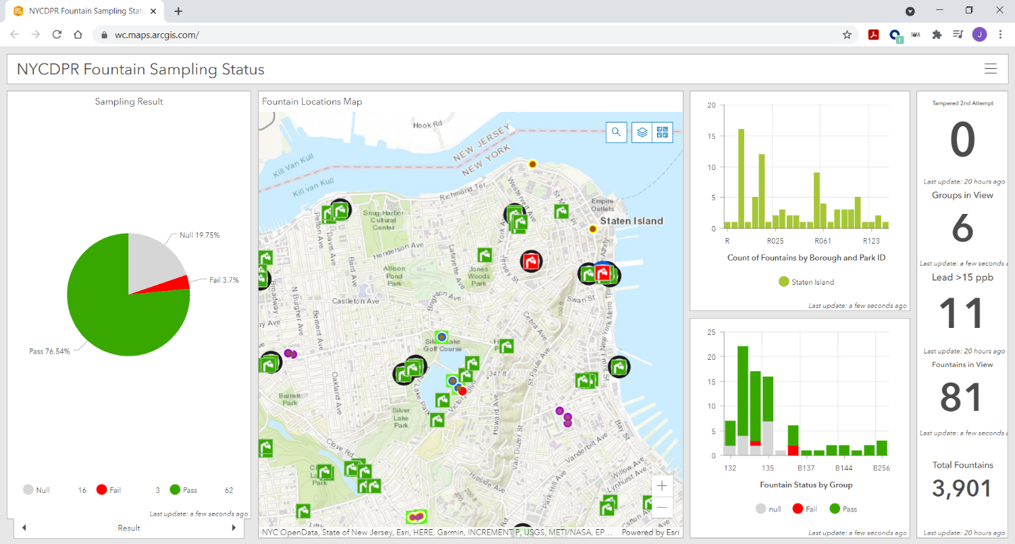
New York City Department of Parks and Recreation (NYC Parks) retained Woodard & Curran to test for sources of lead in approximately 3,500 interior and exterior public drinking water fountains. While the initial proposal estimated eight weeks, the city wanted to fast-track the project with sampling beginning the first week of May 2019 and wrapping within five weeks. With the help of robust existing GIS data for the exterior fountains, Woodard & Curran’s field teams were able to meet this expedited timeline.

GIS data was analyzed to create groupings of fountain sites, organize workflow, and improve efficiency as six teams were deployed six days a week to reach nearly 900 public parks across the city’s five boroughs. Field staff were equipped with mobile devices to use GIS-compatible applications ArcGIS Collector and Survey 123 for real-time recording of sampling progress, asset information, and results reporting. The technology helped managed the need to cordon off each fountain for 8 to 18 hours, return to collect a sample after stagnation, and then a 30-second to one-minute flush sample. This also enabled field staff to build out GIS data for the approximately 500 interior fountains that were not previously listed in the client’s GIS. As the sampling progressed, the real-time collection of information on mobile devices fed into a public interactive map on the NYC Parks website.

Woodard & Curran mapped and took water samples at over 3,500 water fountains across the five boroughs in New York City in 2019.  The effort added many new features which where previously not included in the drinking fountain inventory.

Workflow & Data Accessibility for Town of Cortlandt, New York

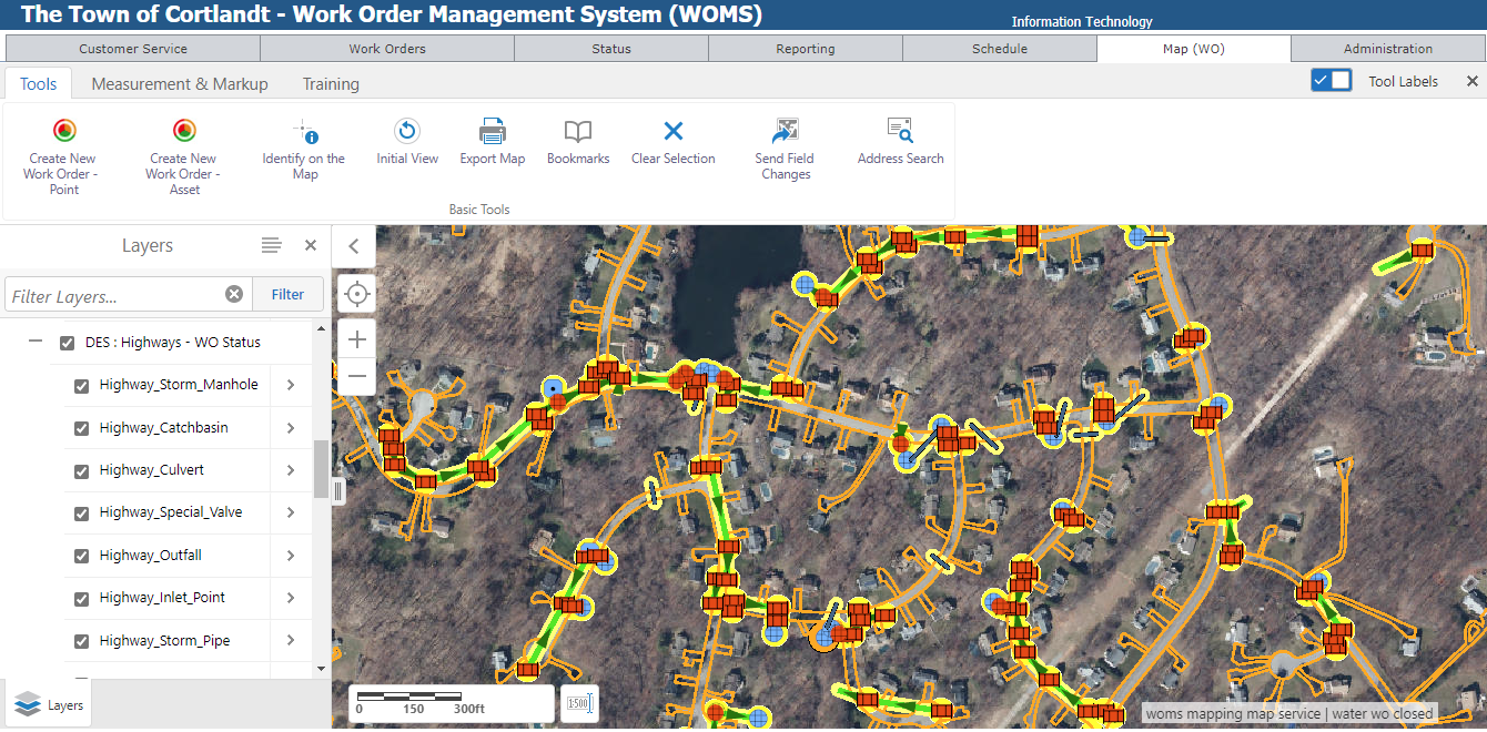
To improve efficiency across municipal departments that relied on information about physical assets, the town of Cortlandt sought to enhance its GIS program. Woodard & Curran worked with the town to identify specific ways to strengthen their GIS program, targeting data quality and work order management as areas of significant opportunity. By focusing on the quality and integrity of data, GIS experts helped develop a public web GIS platform. To further leverage the technology, a work order management system with mapping interface was developed for staff, which allows them to generate and close out work orders while still in the field. All data from the work order system is available to managers, enabling them to see emerging trends and improve planning efficiency.

The Town of Cortlandt (NY) Work Order Management System (WOMS) provides town staff easy access to important municipal work orders (previous, current and pending) covering several operational programs and departments.

Contact:

Anthony Catalano, Senior Principal acatalano@woodardcurran.com
Jake Needle, GIS Program Manager jneedle@woodardcurran.com

Geospatial Student Spotlight: Christopher Plummer

Academic Institution:

The University at Albany, SUNY
Department of Geography and Planning
Pursuing M.S. in Biodiversity, Conservation, and Policy

B.S The College at Brockport, SUNY, Environmental Science and Biology

Research Focus:

Using drones to assess white-tailed deer abundance and habitat preference in the Albany Pine Bush Preserve

Plummer’s overall research goal was to use thermal imaging drones to perform aerial surveys of white tailed deer and associated drone technology to produce an up-to-date habitat assessment of the study area to assess both white-tailed deer abundance and associated habitats. Plummer’s research proposes drones:

  • Offer a faster and lower cost of aerial data capture
  • Can be flown with lower detection from wildlife
  • Can be equipped with thermal sensors to aid in wildlife detection
  • Offer high accuracy population data with robust statistical strength

Study Area and Background:

Located northwest of Albany, the Albany Pine Bush Preserve (APBP) is approximately 3,350 acres supporting a broad variety of habitats highly fragmented by roads developed areas.  Hunting, fishing and trapping are recreational activities that are carefully regulated in the preserve following relevant APBP and New York State Dept. of Environmental Conservation (NYSDEC)  rules and regulations.

Historically, the monitoring of whitetail deer (WTD) has been difficult to establish due to obtaining reliable abundance estimates as traditional survey methods are normally very work intensive and/or expensive.  In the past such estimates have been done within the preserve with spotlight surveys and camera trap surveys.

(Historically, obtaining reliable abundance estimates of white-tailed deer has been difficult to establish, with more traditional methods being work intensive and/or expensive, and having issues with imperfect deer detection. In the past such estimates have been done within the preserve with spotlight surveys and camera trap surveys. Plummer plans to use the findings from the previous work to help understand how the use of drones compares to the more traditional survey methods.

Unmanned Aerial Vehicles (UAV) technology, more commonly called drones, was chosen as a means to facilitate WTD data collection and analysis in the Preserve.  Specifically, DJI Mavic 2 Enterprise Dual was used for the thermal deer survey while other DJI drones (Phantom 4 and  Insprie 2) were used to help create the orthophoto map.  A MicaSense RedEdge 3 multispectral camera which was attached to one of the drones helped pick up additional reflectance characteristics of varying vegetation types.  This camera has 5 bands, with the two additional bands sensing red edge (~715 nm) and near infrared (~825nm) wavelengths.

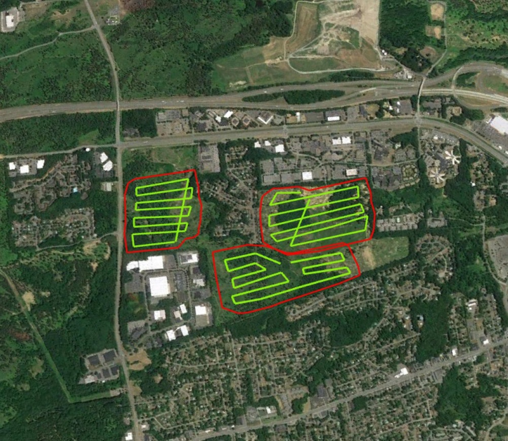
Universal Ground Control Station (UGCS) and DJI Pilot software was used to develop flight plans over three distinct focus areas in the Preserve.  Multiple flights were made to acquire enough images with sufficient overlap.  Plummer used Agisoft photogrammetry software to generate orthophotos of the study areas.

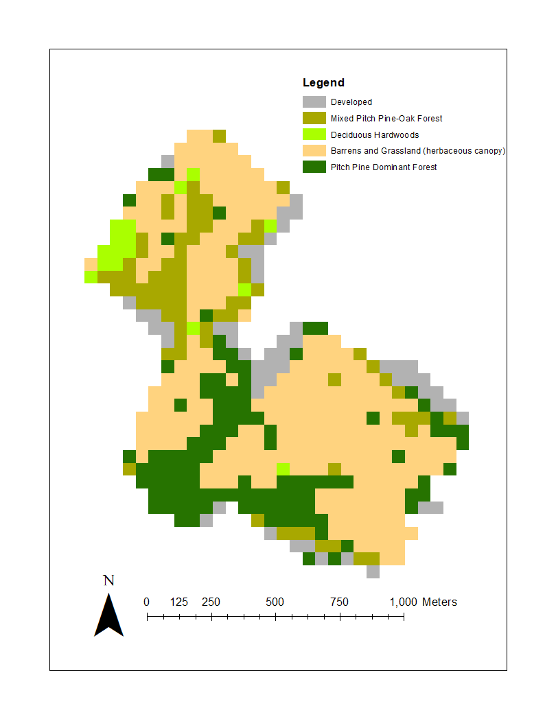
ENVI software was used to generate a supervised canopy cover classification of the study area.  Plummer was able to classify the entire orthophoto with >95% accuracy into herbaceous/open canopy, deciduous canopy, coniferous canopy, bare ground/no canopy, and developed canopy.  ArcMap 10.6 was used in a variety of ways as well as R-Studio and Microsoft Excel for data analysis.

Three flight plans in Blueberry Hill East and West and the Kaikout Kill Barrens

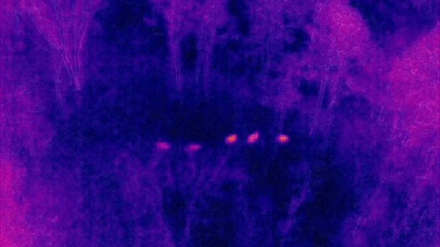
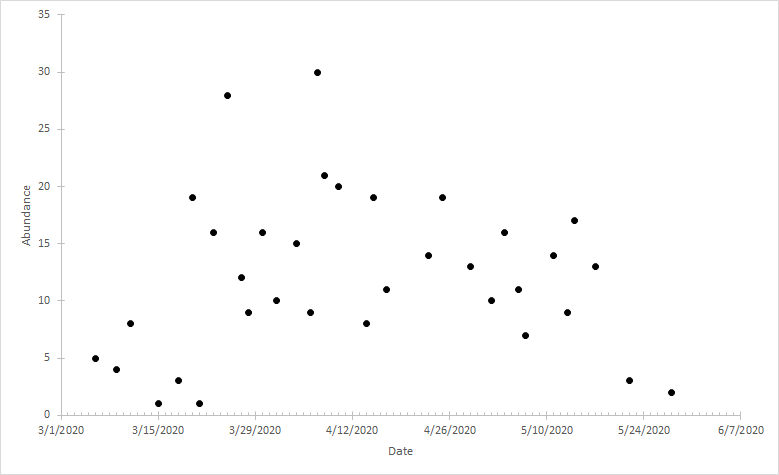
The research team flew a total of 34 surveys between March 9th and May 22nd 2020 with all flights occurring within 1 hour of sunrise collecting over 950GB of imagery files.  A total of 405 deer were spotted and identified in 143 unique locations.

Silhouettes of five deer as seen through Plummer’s use of thermal imaging photography

Project Findings

Plummer’s initial calculated observed average density of 13 deer per sq. km is unlikely to be uniform over the entire Preserve due to varying  landscape dynamics and various habitat types. The abundance within their study area varied widely over time, which Plummer suggests  is explained by daily movements made by individual groups into the nearby residential areas.  With regards to habitats, deer were more frequently found in the following areas of the Preserve:  (1) areas of recent timber harvest, (2) Pitch Pine cover and in the pitch-pine scrub oak barrens, (3) areas with significant dune activity, and (4) close to the edge of Preserve boundaries. He believes this new method for assessing white-tailed deer abundance has high potential in the wildlife monitoring space and hopes  his findings about deer within the Preserve will help generate well informed deer management decisions.

Plummer generated a habitat classification map based on the percent of each canopy type within a 50m x 50m grid covering the entire study area. The Pitch Pine Dominant Forest habitat along the southern border of the Preserve was one of the areas with the highest WTD counts.

Actual WTD observed during any given survey varied over time. Over the near three month data collection period in early 2020, WTD observation counts ranged from 1 to 30

Summary

Plummer’s SUNY Albany graduate work suggests that thermal drones are a viable tool to assess WTD population dynamics and can generate reliable abundance estimates.  Drone deployment provides the ability to survey large geographic areas in a small amount of time and a cost effective manner.  Results show that deer use a variety of habitat types in the Preserve and numbers at any one location varies temporally.  A detailed video presentation Chris made outlining his work to the members of the APBP is available here on YouTube.

Post-graduate work, Plummer would welcome the opportunity to work for an agency such as U.S. Fish & Wildlife Service or NYSDEC Division of Fish and Wildlife. He’s not opposed to going back to school for a PhD but not anything immediately.  He is also very interested in public policy related to climate change and sustainability.

Contact:

Chris Plummer
Graduate Student
University of Albany
Geography and Planning
ccplummer@albany.edu

Dr. Alexander Buyantuev
Associate Professor
University at Albany
Geography and Planning
http://www.albany.edu/gp/Buyantuev.php

Geospatial Business Spotlight: Bergmann (GIS Services and Solutions)

Company Name:               Bergmann (GIS Services and Solutions)

Location:                               Rochester, NY

Website:                                bergmannpc.com

Employees:                        400+

Established:                      1980

Bergmann is a full service, multi-disciplinary design firm employing a wide range of professionals and practitioners in the geospatial  industry.  The company represents four decades of a culture built on the work of client-focused experts. Its core business segments include Transportation Systems, Civil Works, Building Design, Land Development, Community Planning & Design, and Program Services.  Within these areas, Bergmann’s rich portfolio of work features everything from restoration of historical landmarks, to the comprehensive bridge and highway design, to waterfront master planning.  Specific client geospatial support services include:

  • Client Consulting: enterprise strategy, system planning & GIS coordination.
  • Implementation & Support: architecture design, system configuration & optimization & technical support.
  • Software Development: software extensions (ArcGIS & Geocortex), custom solutions (web/mobile/desktop) & system integration.
  • Data Services: database design, data development, and management & data migration.

The Bergmann GIS Services team is a nationally recognized leader in the field of Geographic Information Systems (GIS).  Project Managers, GIS developers, GIS analysts, and 3D Design Specialists offer clients advanced and unique technical skillsets to solve complex information challenges. The company focuses on building strong, collaborative partnerships with clients to create applications, data, and workflows which bring efficiencies and value.

Continue reading