Geospatial Business Spotlight: VHB

Location:                      Albany, New York (30+ locations along the East Coast)

Website:                       www.vhb.com  &  www.vhb.com/albany

Employees:                 180 New York State / 1,600 Nationwide

Established:                1979

The Company

VHB’s 1,600 professionals include engineers, scientists, planners, and designers partner with public and private clients in the transportation, real estate, institutional, and energy markets, as well as federal, state, and local governments. With locations along the East Coast, including five regionally in  Albany, Hauppauge, New York City, White Plains, and Newark, VHB is dedicated to improving mobility, enhancing communities, and balancing development and infrastructure needs with environmental stewardship.

VHB’s integrated services approach leverages a robust line of applied technologies the firm has developed through experience and cooperation with clients and partners. Whether it’s utilizing geospatial technology to pinpoint demographics to enhance decision making or keeping critical projects moving forward by utilizing Big Data, VHB’s team is dedicated to uncovering innovative solutions that benefit the communities they serve.

The following sections cover a few of these technologies, but for more information, please visit VHB’s Applied Technology website.

Geospatial Products and Services:

VHB celebrates a long history with the GIS community, integrating lessons learned and best practices to each new opportunity. As an Esri Business Partner for more than 20 years, and part of Esri’s Business Partner Advantage Program (BPAP) which provides access to Esri’s developers and technical staff, VHB is positioned to understand Esri technology at the highest levels and receive treatment for technical issues and targeted assistance. Additionally, VHB is certified as one of Esri’s ArcGIS Online Specialty partners, which symbolizes the company’s extensive experience in creatively implementing ArcGIS Online/Portal technology within any organization.

Services that are offered by VHB’s GIS consultants include:

Planning Services

  • GIS Strategic Planning
  • GIS Needs
  • Assessments GIS
  • Business Planning
  • ROI Studies
  • GIS Audits

Application Development

  • GIS Web Development
  • Mobile Application Development
  • Spatial Enablement
  • System Integration: BI, CRM, document management, permitting, asset management, etc

Support

  • On-Call Support
  • Technical Training
  • Maintenance of Data of Systems Created
  • Hosting of Web and Mobile Applications

System Design

  • Requirements Analysis
  • GIS System Architecture

Correlating GIS Mapping With Data for Healthy Communities

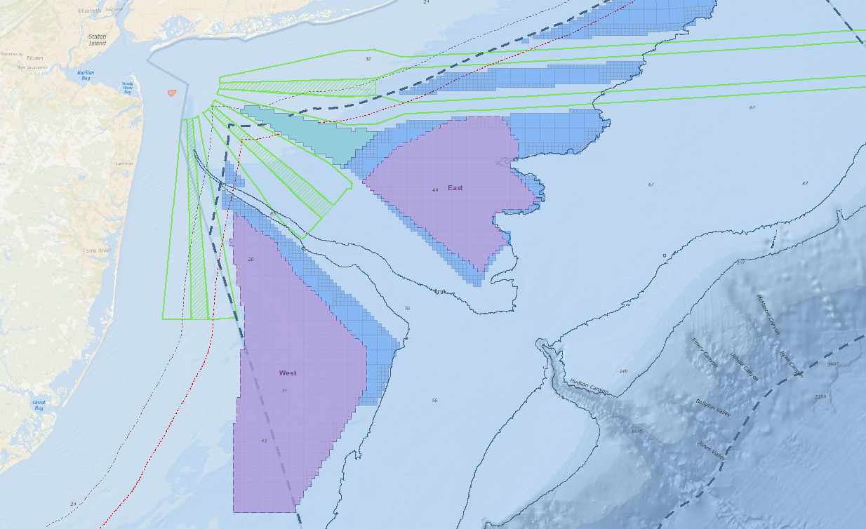
VHB’s innovative Healthy Mobility Model utilizes GIS mapping powered by ESRI to establish a baseline health risk assessment within a designated area by correlating census and published health data with land use, urban design, and mobility data. This assessment, or community health profile, eliminates intensive and time-consuming surveying while identifying and prioritizing improvements.

With the Healthy Mobility Model, municipalities can easily distinguish alternative scenarios and identify factors with the strongest relationships to building better health outcomes while tracking improvements over time. These quantitative results within a given profile help decision-makers think more holistically and support sustainable solutions that consider social, environmental, and economic impacts.

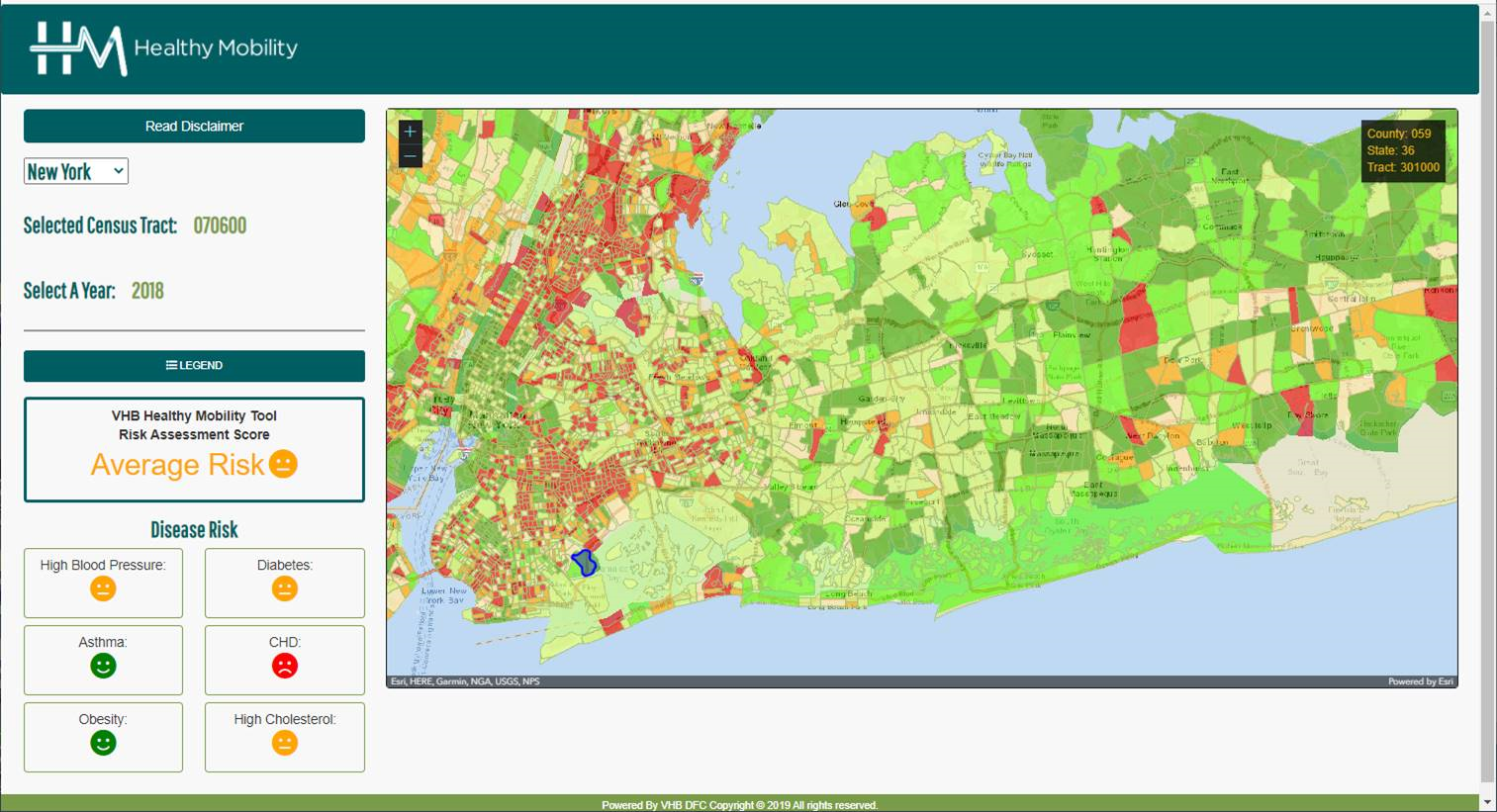
This VHB application combines six census track level disease risk variables to calculate an overall “Healthy Mobility” score. Based on the 2018 data in the application, this Long Island census tract had an overall “Average” risk.

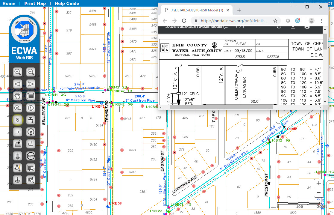
Decoding Parcel Data to Understand Sites

VHB has been creating web-based parcel viewers for county and local government agencies within New York State for more than 15 years.  As internet technology and Esri’s solutions changed over the years, their experienced applied technologists have constantly evolved applications to remain state-of-the-art. The core components of all systems include a suite of GIS functionality and a robust user interface that gives users extensive tools for accessing and manipulating parcel data, including searching for parcel buffers, generating assessor’s lists, and accessing assessment information. Many sites also include custom functionality such as the creation of a parcel flyer, the calculation of wetland acreage, and the displaying of documents from other systems.

VHB has implemented numerous web-based parcel viewer applications for local and county governments within New York State, including:

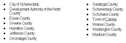
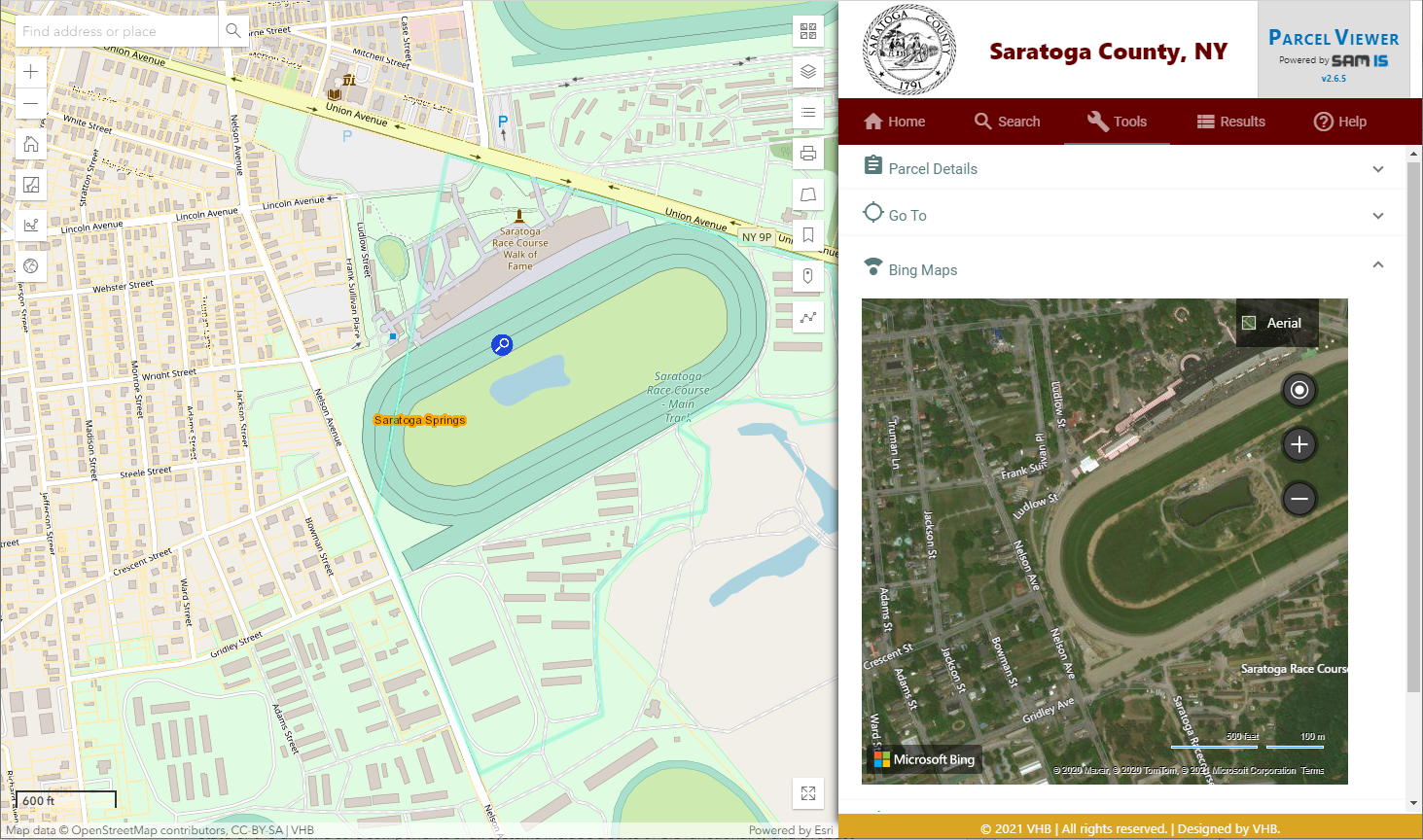
VHB property/parcel viewers integrate a variety of spatial datasets from local, county and state data sources. The applications provide a range of functionality at the parcel level.

Leveraging Big Data and Traffic Analysis to Keep Projects Moving

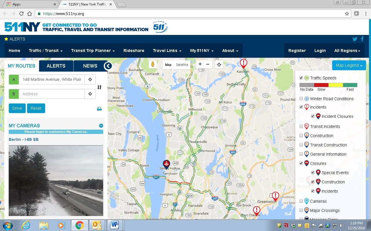
Collecting traffic data is a critical piece of advancing transportation projects. Intersect, VHB’s latest technology-driven innovation, revolutionizes the way traffic volumes at urban, suburban, or rural intersections are quantified during typical and atypical circumstances. As a transportation planning tool, Intersect combines big data analytics and traditional traffic analysis to identify traffic data at intersections more efficiently than ever before, without the need for traditional manual or electronic counts.

By leveraging big data and traffic analysis through an innovative four-step process, Intersect keeps critical projects, and Departments of Transportation initiatives, moving forward.

Turning Data into Action

Since no municipality is exactly alike, collecting data on buildings can be an incredible challenge, especially when these results are needed quickly and efficiently.

VHB’s Cultural Information Resource System (CRIS) was developed for the New York State Historic Preservation Office (SHPO) as a web-based resource information system to catalogue and manage the agency’s huge range of programs and assets. CRIS records and manages data concerning the cultural resources within the State and gives both SHPO and their partner agencies a platform to submit, review and process wide varieties of historic preservation projects—effectively eliminating bottlenecks during a review process. CRIS also eliminates nearly all physical paperwork to help streamline record-keeping.

In the wake of Superstorm Sandy in 2015, VHB launched CRIS Trekker as a mobile-friendly enhancement to CRIS to help SHPO assess the condition of historic buildings and resources within the areas affected by the storm. CRIS Trekker captures real-time data in the field utilizing an easy-to-use interface that allows users to simply fill out a form, take a photo with their device, and submit digitally. The enhanced flexibility makes submitting, storing, analyzing, and managing incoming building surveys faster and more efficient.

In early 2020, VHB launched CRIS Trekker 2.0, a complete re-engineering of CRIS Trekker based on the latest Esri GIS platform. In the field, CRIS Trekker 2.0 has been critical in keeping technicians safe and allowing building surveys to continue.

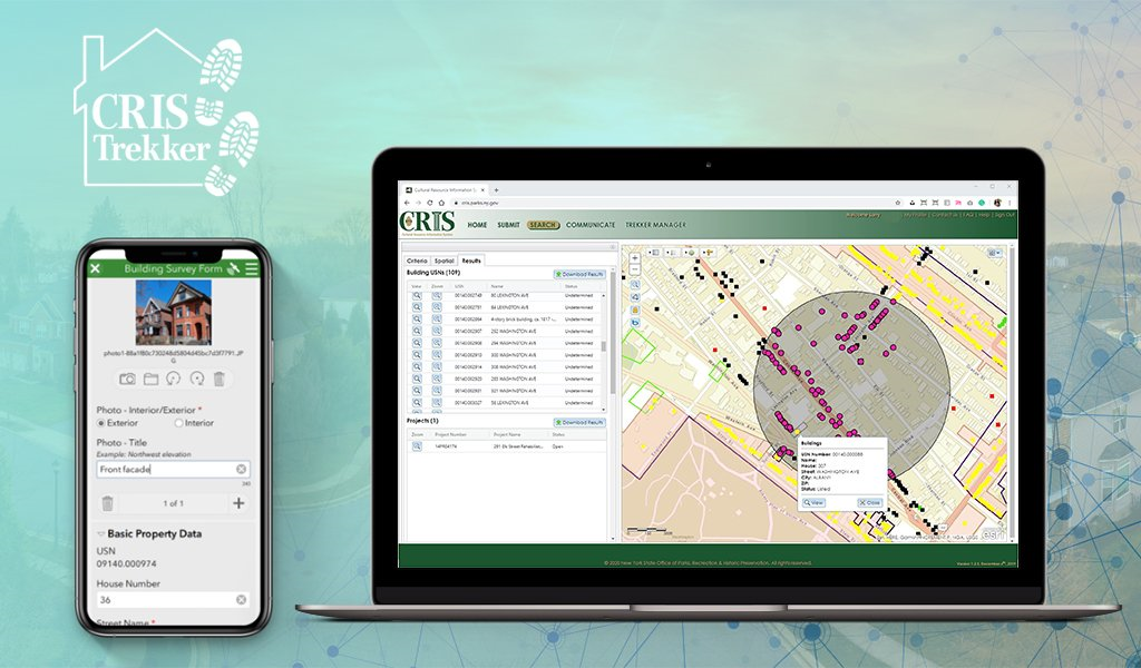
The combination of CRIS and CRIS Trekker 2.0 has provided SHPO with an integrated digital platform to enable the continued review and processing of incoming projects without interruption during the COVID-19 pandemic.

Improving Mobility & Safety in Communities

VHB designed the enterprise-level Highway Crash Geocoding & Safety Management Systems to help state transportation agency clients improve mobility and communication within the communities they serve. This future-focused technology manages the safety of community streets and roadways, streamlines workflows and processes, and helps agencies (like those listed below) deploy responses with enhanced speed and accuracy.

For NYSDOT, VHB is developing a new, customized suite of applications collectively called the Crash Location and Engineering Analysis Repository (CLEAR) system. CLEAR provides a series of modules for geocoding, editing, and managing crash data while providing tools for conducting the six-step safety management process to improve roadway safety and reduce the number of crashes, injuries, and fatalities within the state.

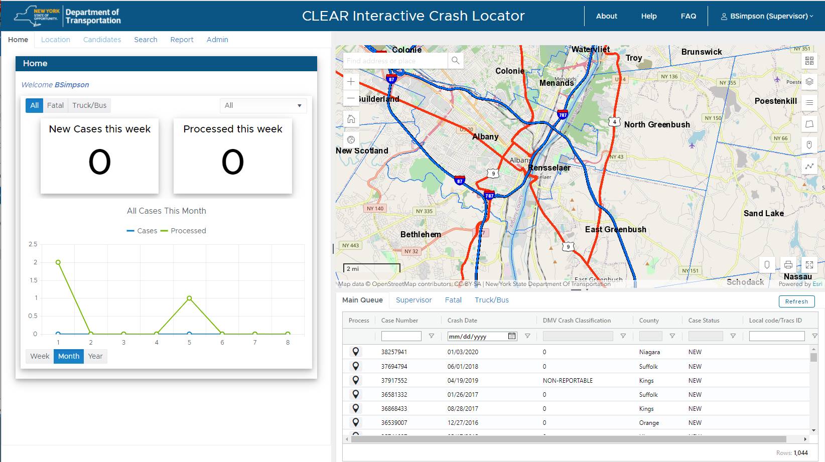
The CLEAR internal facing password-protected application provides NYSDOT staff a suite of tools to analyze statewide passenger and truck vehicle accident location data. Similar to all of VHB browser-based geospatial tools, the application is built on top of ESRI ArcGIS Online technology.

Managing Assets for Streamlined Capital Planning

 VHB’s Smart Asset Management and Inventory System (SAM IS) helps clients keep track of their inventory of physical assets, inspections, and maintenance so that capital planning can proceed without a hitch. The system is built on Esri’s ArcGIS Online platform and designed it to be intuitive and scalable so that whatever the need, clients can track and manage assets without over-spending valuable capital. Since it is cloud-based, SAM IS offers broad accessibility to anyone within an organization with basic Internet access. SAM IS dashboards also readily provide the information needed to help make more informed decisions and deliver projects faster, safer, and more efficiently. Available nationwide, both the City of Albany, NY, and the County of Westchester, NY, currently subscribe to SAM IS.

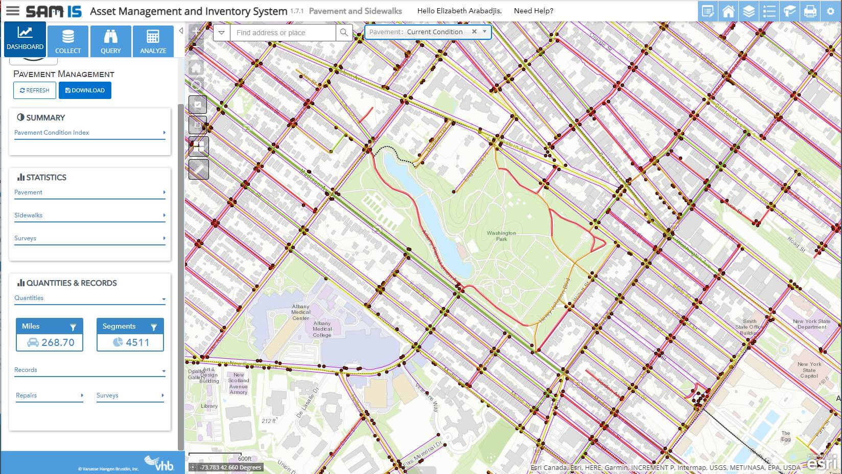
The VHB SAMIS application provides a wide range of functionality to clients including access to mapped infrastructure features, statistics, dashboards, and an interface connection to mobile data collection efforts.

Contact:

Steve Anderson, GISP
Director, VHB Applied Technologies
sanderson@vhb.com

Editor acknowledges the contribution of Elizabeth Arabadjis in preparation of this article

D.I.Y MS4: Erie County

The County’s Homegrown Application Provides Mapping and Data Collection Support to the Multi-Agency Western New York Stormwater Coalition

While the  Municipal Stormwater Sewer System (MS4) regulatory program may be taking a back seat in focus to COVID-19 across Empire State governments in 2020, compliance efforts nonetheless continue in the background.  The DEC program has seen governments responding to meet annual submission requirements in a variety of ways ranging from full vendor supported solutions, hybrid approaches of using in-house resources and commercial-off-the-shelf (COTS) products, while others have built the solution totally in-house.  Aka Do-it-Yourself (DIY).

One such MS4 DIY organization is Erie County which provides administrative and technical support to the Western New York Stormwater Coalition (WNYSC) which has a broad geographic footprint.  Erie County took the stormwater management regional lead in western New York in 1999 when it became apparent both Erie and Niagara Counties would be required to come in compliance with the United States Environmental Protection Agency (U.S. EPA) Phase II Stormwater requirements. Recognizing much of the MS4 General Permit was general in context of most permit requirements being the same for all governments, the Coalition was created in 2003 as a means to share work such as public education and outreach, development of policies and procedures, employee training – and mapping.  While the Coalition is not an official Erie County government agency, it is housed administratively inside County offices.

Erie County MS4 Support 

Initial development of the program started in 2012 by the current Director of Erie County’s Office of GIS, Lisa Matthies-Wiza, who was part of a team that designed databases, field applications, and quality assurance plans to manage data collection.  This was facilitated through a series of grants through NYSDEC and partnerships with Erie County and Buffalo State College provided to the Coalition.

More recently, support to the Coalition’s MS4 compliance efforts has been Michael Ruffino who came to the County in March of 2019.  Prior to Erie County, he had experience in the use of ArcGIS Online (AGOL) Survey123 and Collector in Chautauqua County where he was able to incorporate similar apps for the environmental health department septic systems and water supply inspections.  Currently Erie County hosts all of the GIS data and hardware/software infrastructure for the entire WNYSC program.

Continue reading

Focus on Hudson River Flooding Impacts

Online Application Provides Tools and Data for Communities at Risk Along the Hudson River

Background

The Hudson River Flood Impact Decision Support System (HRFIDSS) is an online mapping application as well as a collection of geospatial products and data which illustrate the scale of potential flooding for tidally-affected shorelines of the Hudson River Valley and Westchester County coastal communities. In all, the viewer covers the shoreline communities in 11 counties in the region.  Developed by researchers from Center for International Earth Science Information Network (CIESIN), Stevens Institute of Technology, and the Columbia Water Center, the application enables individual residents, community groups as well as municipal and regional planners to evaluate risk based on potential outcomes, and to determine the impact on and effect of social vulnerability, natural resilience, and critical infrastructure.

The tool also provides downloadable estimates of flooding impacts, including affected population and critical infrastructure, and cost estimates of building damage.  It is further enhanced by including hydrological models which expands the flooding impacts to include storm tides/storm intensity and the contributions of river tributaries and streams.

The Hudson River Flood Impact Decision Support System helps address the growing interest across all levels of government in the New York region towards developing better forecasting capabilities and a better understanding of flood probabilities under a variety of sea level rise and storm frequency scenarios.

The application was developed using OpenLayers.  Critical infrastructure data is housed in a relational PostGIS database which are served as a Web Feature Service (WFS) using Geoserver.  Flood layers are raster data published from an ArcGIS Server at CIESIN while supporting imagery layers are consumed from New York State.

Impact Assessments

In addition to a variety of unique mapping tools, one of key features of the application is the generation of “Impact Assessments”.  These are generated by application flood maps using a combination of historical and synthetic flood events which include water depth, surge, rainfall, and  sea level rise scenarios of 0″, 6″, 12″, 18″, 24″, 30″, 36″, 48″, 60″, 72″ as well as 5-year through 1000-year flood zones.  Flood scenarios presented in the mapping tool are accompanied by a set of impact estimates at the local level. These are divided into three themes: critical infrastructure, social vulnerability, and natural resilience features.
Continue reading

Geospatial Business Spotlight: Bergmann (GIS Services and Solutions)

Company Name:               Bergmann (GIS Services and Solutions)

Location:                               Rochester, NY

Website:                                bergmannpc.com

Employees:                        400+

Established:                      1980

Bergmann is a full service, multi-disciplinary design firm employing a wide range of professionals and practitioners in the geospatial  industry.  The company represents four decades of a culture built on the work of client-focused experts. Its core business segments include Transportation Systems, Civil Works, Building Design, Land Development, Community Planning & Design, and Program Services.  Within these areas, Bergmann’s rich portfolio of work features everything from restoration of historical landmarks, to the comprehensive bridge and highway design, to waterfront master planning.  Specific client geospatial support services include:

  • Client Consulting: enterprise strategy, system planning & GIS coordination.
  • Implementation & Support: architecture design, system configuration & optimization & technical support.
  • Software Development: software extensions (ArcGIS & Geocortex), custom solutions (web/mobile/desktop) & system integration.
  • Data Services: database design, data development, and management & data migration.

The Bergmann GIS Services team is a nationally recognized leader in the field of Geographic Information Systems (GIS).  Project Managers, GIS developers, GIS analysts, and 3D Design Specialists offer clients advanced and unique technical skillsets to solve complex information challenges. The company focuses on building strong, collaborative partnerships with clients to create applications, data, and workflows which bring efficiencies and value.

Continue reading

10 Questions: Christine Gayron, Gayron de Bruin Land Surveying and Engineering, PC

Christine Gayron currently serves as President of Gayron de Bruin Land Surveying and Engineering, PC (GdB) based in Melville, New York.   The company provides a wide range of geospatial products and services for clients in the Empire State.  As part of eSpatiallyNewYork’s continued effort to reach out to the statewide geospatial professions, we were able to meet and have a conversation at the 2019 New York State Association of Licensed Surveyors (NYSAPLS) annual conference.

eSpatiallyNewYork:  GdB was created in 2010.  The company has made a lot of progress in a relatively short period of time and adding a lot of new technologies along the way – GIS, drones, laser scanning, etc. – how is the company making it all happen?

Gayron:  I only hire people who are awesome. They are the ones who make it happen. I just bring in the work and create a company culture that makes the employees want to be the best at what we do. I have to credit my partner, Greg de Bruin, for constantly pushing the envelope, and insisting on investing in technology, and Jason Graf, my partner in charge of operations, for putting the technology in everyday use. Greg introduced GIS in the 90’s before I started my career. I actually think my contribution was my ability to run the business and bring work in, creating a revenue stream that would allow us to afford to make the investments. So I grew the company and oversaw things and generated profit, while the technology nerds in the company figured out how to customize software and put new technology into use.

eSpatiallyNewYork: Tell me a little bit about your education.   B.S. in Geology – how did you make the jump to surveying?

Gayron: I have a BA in Geology from CUNY Queens College and a minor in secondary education. I thought I was going to be an Earth Science teacher, but a month into student teaching, I realized teaching was not for me. I wasn’t sure what to do. My stepfather saw an ad in the paper for GIS Specialists at an engineering firm called A. James de Bruin & Sons, the predecessor firm to Gayron de Bruin.  It was in Bethpage, NY, the next town over from where I live. I had taken one class in GIS in college. The mapping aspect of geology interested me more than the rocks and minerals part, so I applied for an entry level position. I was hired to draft utilities and base maps for utility company conduit design drawings. Then I worked with one of the engineers on the conduit design. I designed hangers to support conduits underneath a couple of bridges over the Long Island Expressway (LIE).   I also designed horizontal directional drilling of conduit underneath the LIE. When the conduit design work dried up, I started doing more boundary surveying and control surveys for NYSDOT.  I used GIS to plan control networks.  At 23 years old, I was managing design survey projects. There was lots of opportunity at the small family owned firm and I was good at seeing what needed to get done. As I approached licensure in 2010, my boss, Greg de Bruin, and I decided to partner and form Gayron de Bruin.  It was time for Greg to start planning for retirement and I was the successor.

eSpatiallyNewYork:  Early on, traditional surveying and engineering companies were a bit slow embracing GIS technology/software but today this intersection is complete.  GdB is part of the ESRI Partner Network and has ArcGIS Online Specialty Did GdB have ESRI capacity from the beginning?

Gayron:  We’ve always been an ESRI shop. We saw how ESRI had discounted licenses for schools and government and we knew that was key. As we are geospatial data collectors and data managers we push GIS as a data management tool to our clients.  We try to provide this to all of our clients. GIS is just one of the tools in the toolbox. It used to be a hard sell to get clients to use GIS, but ArcGIS Online (AGOL) has made that a lot easier because we can set up the GIS tools, bring the data in, and show them how to view, analyze, and manipulate it.

eSpatiallyNewYork:  Are the new/younger generation of surveyors – and engineers – who are just getting into the work force have a broad enough understanding/experience with GIS software?

Gayron:  We hire a lot of people right out of college with GIS education. We find that they have a basic understanding of what it can do, but how we use it in surveying and engineering is usually new to them. Most of it is learned along the way. I think this is true of most industries – college gives a basic foundation and only scratches the surface. Getting into the workforce is where the detailed applications and user expertise is developed.

eSpatiallyNewYork:  Speaking of data, what has GdB’s experience been in obtaining government data?  I see that elevation certificates and tax parcel data are key business components in your space.    What’s been your experience in getting this digital data across New York State?

Gayron: Orthoimagery has been very attainable and useful. Parcel data is useful for elevation certificates as you suggested. Tax map line work is valuable for getting an idea of what the parcel layout may look like, but it can be deceiving. We try not to use it on our drawings because we are licensed land surveyors and if we put a line on the drawing, it’s got to be in the right place. We love to see government offices scanning their maps and storing them in a GIS and making them available, but this is still rare.

eSpatiallyNewYork:  Drone technology is becoming a geospatial game changer.  What’s the GdB read on this evolving technology?

Gayron: So drones are all the rave, but they are really just another cool option in the geospatial tool box – a glorified robot camera holder.   It’s really the software that connects drone flights to GPS and uses drone photography to create point clouds and 3D surface models that I find impressive. Like other tools such as LiDAR, it is the accurate and precise control that yields accurate 3D models. The software is key in reconciling the data with the ground control.

eSpatiallyNewYork:  This is impressive  – “GdB is ranked in POB Magazine as one of the top 100 Geospatial firms in the United States.”

POB magazine gathered data in 2015 and 2016 on revenue in the geospatial community. I’m attaching the articles so you can see how they used the data to rank firms. They stopped doing it after 2016, but I’m certain we would rank even higher on the list now!

eSpatiallyNewYork:  How does Honeoye Falls, New York fit into the GdB business plan? It’s a long way from your Long Island headquarters!

Honeoye Falls is just outside of Rochester. So we wanted to expand the company and it seemed we had the choice to expand geographically providing the same services or we could expand our range of services to include more civil engineering. We decided to stick with what we are good at and do it farther away. My partner, Jason Graf, LS, found New York State Department of Transportation (NYSDOT) data available online. It listed NYSDOT projects by location and contract budget. He manipulated the data in GIS and created a heat map to see where NYSDOT was spending the most money. The New York City area glowed the brightest, of course. The next “glowiest” cities were Buffalo, Rochester, and Syracuse. With Rochester in the middle of those three cities, it seemed like a place to look into. We had some contacts there and did our research. Within one year of starting to think about a Rochester office, we had the branch office open with 5 employees. 18 months later, we have 11 employees and they are all busy! Scott Smith, LS, the Branch Manager, is building an all-star team upstate. I truly believe that the bringing on the right people drives our success. As we grow, we are putting effort into making our operation more structured and efficient, but as stated above, we only hire people who are awesome, and I want them to feel appreciated for their ideas and contributions.

eSpatiallyNewYork:  What are some of GdB’s current larger or unique projects using geospatial technologies? 

Power companies are putting out very large corridor projects requiring surveying and mapping of several miles along a proposed power line route. I think these projects are coming about as new forms of energy generation are being developed. They need transmission lines to connect the new power plants, solar panel fields, and wind farms to traditional power grids. We also do large mapping projects for design of infrastructure in New York City. The city’s infrastructure is crumbling and needs upgrading. One of the first steps is mapping the existing conditions. These jobs are always a huge rush.

eSpatiallyNewYork: Considering all of GdB’s business – what is the breakdown between private and business clients? 

Most of our work is for government agencies. The breakdown is aboutt 80% government agency work, and 20% private clients.

eSpatiallyNewYork: Tell us about the online teaching you do through GeoLearn?

I met Joe Paiva, the founder of GeoLearn, before I got licensed because I took his review course when I prepped for the Licensed Land Surveyor test, and then I would see him at conferences a couple times per year. Joe is an excellent presenter. Joe knew that I was doing some presentations to professional organizations and he knew that my company was using GIS and other new technologies in Land Surveying – so he asked me to present courses on GIS for GeoLearn.  I prepared power point slides just like I would for a live presentation. I flew to GeoLearn’s studio in Kansas City to record them. It’s actually much easier to present this way, because you only have to present 10-15 minutes at a time to create the segments. Being in the studio was a very cool experience!

eSpatiallyNewYork:  Work aside, I understand you’re a triathlete and compete in many similar events.  What’s next on your calendar? 

Last year, I qualified for XTerra World Championship race in Maui. This is an off-road triathlon consisting of an ocean swim, mountain bike, and trail run. Unfortunately, I was injured a couple weeks before the race and didn’t go. This year, I am not signed up for any races, which is an interesting experiment, because I’m still training, but without the pressure of an upcoming race. So I know I’m doing it because I really love it. I usually wake up at 4:30am and train early in the morning. I’m done by 8am in time to get my kids off to school and get to work. I am married to a NY City Firefighter and we have three amazing children, who are very active. Right now, I’m ok with putting my racing career on hold to attend their lacrosse games, concerts, and cheer competitions.

Contact:

Christine Gayron, President
Gayron de Bruin Land Surveying and Engineering, PC
cgayron@gayrondebruin.com

Geospatial Business Spotlight: Ecology and Environment, Inc.

Company Name:                  Ecology and Environment, Inc.

Location:                               Lancaster, New York

Website:                                www.ene.com

Established:                         1970

Ecology and Environment, Inc., (E & E) is a global network of innovators and problem solvers, dedicated professionals, and industry leaders in scientific, engineering, and planning disciplines working together with our clients to develop technically sound, science-based solutions to the leading environmental challenges of our time. Founded in 1970 in Lancaster, NY, E & E also has offices in New York City and Albany, as well as locations across the national and internationally. E & E is a fully integrated environmental and engineering company delivering expertise across energy, site assessment and remediation, and restoration and resilience practice areas.

Geospatial Products and Services:

In October 2018, E & E’s IT/GIS group was rebranded as the Data Intelligence Group (DIG) to better reflect the capabilities and services of the department, and how that translates into identifying and integrating opportunities for innovation and streamlined data management into client projects. DIG includes experienced professional application developers and geospatial analysts who collaborate to add value for clients by providing tailored tools to collect and manage data efficiently, collate information quickly to meet aggressive schedules, accurately visualize project data, and support community engagement and project collaboration. E & E has worked on thousands of IT and GIS projects, and has built an extensive library of code that can be efficiently leveraged to complete successful new applications for clients quickly.

Specific E & E geospatial services include:

  • Custom Application development (public and private websites)
  • Needs Assessment, System Design, Development, Implementation and Maintenance
  • Database Development and Data Management
  • Data Visualizations (e.g., Tableau, ArcGIS Insights)
  • Field Data Collection and Management (GPS, Mobile Mapping)
  • GPS/GNSS Support
  • Mobile map viewers and custom mobile application development
  • 3D Visualization and Modeling
  • Photo Simulations
  • Software and system integration
  • Website design, hosting, and maintenance
  • Document Management
  • Satellite Image Processing
  • Database design, interpretation, and migration
  • Training and Technology transfer
  • Web-integrated Monitoring of Telemetered Data Feeds
  • Unmanned Aerial System (UAS) Site Survey
  • Augmented and Virtual Reality
  • GIS Process and Workflow Analysis
  • GIS Training
  • Desktop Geospatial Services (e.g., Cartography/Report quality mapping, Geospatial Analysis, Spatial interpolation and Modeling)
  • Process Automation

Mapping Offshore Wind for NYSERDA

To support New York State’s commitment under the Clean Energy Standard, which requires that 50 percent of the State’s electricity come from renewable energy sources, E & E worked closely with the New York State Energy and Research Development Authority (NYSERDA) to contribute to the first-of-its-kind New York State Offshore Wind Master Plan. The plan lays out a path for development of 2.4 gigawatts of offshore wind – enough to power 1.2 million homes. Geospatial tasks associated with this project included:

  • Development of an interactive web mapping portal for team and public engagement
  • Offshore and near-shore data acquisition
  • Geostatistics of potential offshore wind development areas
  • Development of detailed map figures for published reports

Areas for consideration and indicative wind energy areas were one result of the GIS analysis performed with NYSERDA.   NYSERDA’s findings were presented to the Bureau of Ocean Energy Management to assist in designating official wind energy lease areas.

E & E also developed GIS modeling that ranked sensitivity of various offshore species receptor groups to the stressors of building and operating a wind farm over different times of the year. Geospatial data and analysis results were used to facilitate identification of areas for consideration for offshore wind development and will inform future developers, potentially reducing the uncertainty and costs of their proposals.  Download a copy of the actual Offshore Wind Master Plan.

Geospatial Services for Erie County Water Authority

E & E is proud to have worked with the Erie County Water Authority (ECWA) since 2003, helping them integrate and leverage increasingly robust geospatial technologies to benefit their customers and their bottom line. E & E’s GIS support has been critical to their day-to-day operations. E & E GIS support has provided:

  • Field crew mobile access to utility information though maps and data,
  • Analysis of water main leaks to target most-effective replacements, facilitating smart capital improvement project planning, and
  • Transportation logistical support by optimizing service calls to save on transportation and labor costs.

GIS has played a significant role in the location and management of assets at ECWA for the past 25 years. Pictured here is a web mapping application for use in the office, with field laptops, and mobile devices, that assists with locating and identifying assets and related information.

Geospatial Flows for Energy Infrastructure Developers

For the Williams Transco 197-mile Atlantic Sunrise project, E & E set up field data workflows for a large environmental survey. In communication with E & E biologists, developers, and the client, E & E developed a customized workflow to meet diverse needs. Solutions included development of a customized ArcPad (Trimble) and ESRI Collector Application, web integration, and desktop automation tools.

ESRI Collector and the ArcGIS Online platform played an important role in the Atlantic Sunrise field data collection process. Data was integrated in near real-time and was made immediately available to project managers, engineers, and decision makers.


Working Smarter with E-Datasheets

E & E has ditched paper datasheets and is going green! We developed custom “smart forms” that utilize drop-down menus, radio buttons, and behind-the-scenes calculations to speed up the data collection process. These electronic datasheets save time and improve data quality.  Data is stored in an enterprise database and can be queried and exported to PDF format for report submittal.  E-Datasheets have been used with a wide variety of clients.

E & E has developed electronic datasheets to save time, improve data quality, and reduce waste.

Contact:

Greg Coniglio, PMP, GISP
Ecology and Environment
368 Pleasant View Drive
Lancaster, New York 14086
gconiglio@ene.com

Geospatial Business Spotlight: CycloMedia Technology, Inc.

Company Name:       CycloMedia Technology Inc.

Location:                   Berkeley, CA

Website:                    www.cyclomedia.com

Employees:               120 Globally

Established:              1981

A privately held company, founded in the Netherlands over thirty years ago, CycloMedia Technology, Inc. is a rapidly expanding international company with staff in Syracuse, New York.  Annually, CycloMedia captures and processes approximately 160,000 linear miles of 360° panoramic street level images, representing over 48 million recordings per year. The company holds five key image capture technology patents and specializes in the local government market. Currently the company has projects with the cities of New York, Philadelphia, Washington DC, as well as  Franklin County, OH (Columbus), Dakota County, MN (Minneapolis) and Jefferson County, KY (Louisville) to name a few.

Specific benefits of Cyclomedia technology include:

  • GeoCyclorama images and basemaps are geographically linked
  • Provides ability to conduct searches with address, postal code or coordinates
  • Integrate with interprise applications and work processes using the GlobeSpotter API
  • Determine the location and dimensions of objects in GeoCyclorama imagery
  • Ability to create precise point, line and area measurements
  • Overlay enterprise spatial data on the GeoCyclorama images
  • Supports Open Geospatial Consortium (OGC) standards
  • Integrate data in formats such as WFS, WMS, Shapefile and GML
  • Create reports and bookmark locations of interest
  • Users can save and utilize GeoCyclorama images for reporting and analysis functions.

Geospatial Products and Services:

A.  GlobeSpotter

GlobeSpotter (web) is an interactive web-based application that provides cloud access to GeoCyclorama imagery and tools for measuring, collecting data, and reporting.  The software and data are directly available from CycloMedia’s software as a service (SaaS) model.

GlobeSpotter (web) screenshot with area measurement and reporting window 

GlobeSpotter for ArcGIS Desktop  provides visualization, measurement and overlay tools within the ArcMap or ArcGIS Pro allowing a user to fully leverage the power of GeoCycloramas within the ArcGIS client environment.  Specific capabilities include:

    • Open GeoCyclorama imagery from a recording point layer added to the map
    • View one or multiple GeoCyclorama images
    • Measure on GeoCyclorama images
    • Use the native editing capabilities of ArcGIS to collect features in 2D or 3D
    • Ability to save and utilize GeoCyclorama images for reporting and analysis functions.

Continue reading

Views on the 2018 New York State Geospatial Landscape

There’s probably enough below for a couple blog posts but I ended up throwing everything in together and stirring it up – so to speak.  The language on Part 189 (tax mapping) could be a post by itself.  Kind of all over the place, even revisiting some topics I’ve touched on before as part of eSpatiallyNewYork.  Part wish list and part commentary.  Ten items. More or less.

  1. Promoting NYS Local and Regional Government GIS Development:  This is a frequent mantra of mine and with the  constant advancements in computing and geospatial technologies it’s worth considering on a regular basis.   And most certainly as part of this year’s wish list. Opportunities abound across the Empire State to help local and regional governments  jumpstart and/or solidify their GIS program.   For example, funding is available through the NYS Environmental Facilities Corporation focusing on infrastructure systems much of which is managed at the local level.  Or the large amounts of funding being made available as part of Zombie Remediation and Prevention Initiative through the NYS Office of the Attorney Genera  And the detailed inter-government discussions on the new Shared Services Initiative  which includes funding as part of the adopted FY2018 state budget.  GIS is the shared services technology. And regional GIS programs as part of the New York State Regional Economic Development Councils or by extension the New York State Economic Development Council?   GIS tools are at the foundation of economic development.   Not perfect fits,  but funding opportunities do exist in these program areas.

At the core of local and regional GIS programs is powerful server technology (local and hosted) that not only has the capabilities to support multi-government day-to-day business functions  but also provides the framework to publish geospatial content via map services.  Call it what you want Open Data, government transparency, or data sharing  but it is within this context that state agencies, nonprofits, academia, as well as  business and industry all have access to local data.  Let’s have 2018 statewide focused discussions on extending local and regional GIS capacity based on cost effective and server-based multi-government initiatives.

  1. Building GIS Association Legislative Capacity: While the Association has grown in so many positive ways over the past decade, the challenge continues for the organization to have its presence and mission heard in Albany’s governing hallways.  It is no small effort – organizationally and financially  to build this capacity.  Many similar professional organizations have full-time staff and Executive Directors whose job is to create awareness among elected officials, secure funding, and promote/influence legislation on behalf of the membership.    But currently the Association’s legislative efforts are in the hands of member volunteers.  And while Legislative Committee volunteers were able to coordinate a “Map Day” last May in Albany to introduce the Association to elected officials, the Association has yet to establish itself on the same playing field of recognition with other statewide geospatial heavyweights such as the New York State Society of Professional Engineering, New York State E911 Coordinators, and the lobbying efforts of large New York State based geospatial businesses.  Complicating the equation are Association members who hold licenses or certifications in other professions (i.e, engineering, surveying, photogrammetry, landscape architecture, AICP,  etc) and find themselves in a quandary as to support the Association’s agenda or the profession/discipline which holds their license.  To some degree, this issue manifest itself as part of the discussion with the Geospatial Data Act of 2017 which initially had lines of support drawn heavily along professional affiliation.  The Association must keep up the good effort and find a way to compete on the Albany stage.  Let’s hope the Legislative Committee can build upon its 2017 accomplishments and make further inroads in 2018.
  1. New York State Geospatial Data Act of 2018:   Not really,  but it DOES sounds great – right?   Close our eyes and make believe there is a state-equivalent of the much hyped (Albany) federal National Geospatial Data Act (NGDA) of 2017.   Just think of it:   A process across the Empire State in place to magically aggregate our local government tax-payer funded geospatial data assets into National Spatial Data Infrastructure (NSDI).  Newly appointed and designated state agencies responsible for providing support (similar to the designated federal agencies)  to make our geospatial contributions consistent with the federal data themes and standards as outlined in Section 6 and 7 of the proposed NGDA legislation.  Ultimately being made available via the GeoPlatformContinue reading

Geospatial Business Spotlight: Bowne Management Systems

Company Name:         Bowne Management Systems, Inc.

Location:                     235 E. Jericho Turnpike, Mineola, NY  11501

Website:                      http://www.bownegroup.com

Employees:                 35

Established:               1982

Bowne Management Systems (BMS) is unique in the technology world as the firm has been in business since 1982.   2017 marks the 35th anniversary of BMS and they proudly state “we innovate every day.”

The collective team of professionals are not only fluent in IT and geospatial technology but in the core competencies of any business – professional project management, diverse and adaptable skill sets and most importantly, customer relationships and satisfaction.

BMS is associated with their affiliate, Sidney B. Bowne and Son, a nationally recognized civil engineering and surveying firm that has been in business in New York State since 1895. The shared corporate culture and values has kept Bowne in the forefront for almost 125 years.

BMS has developed core practices to support the mission critical operations of local government. This client base includes local government at all levels, as well as State and Federal government agencies, and private clients. BMS has core practices in the following areas:

  • Public Safety
  • Land Records and Tax Mapping
  • Infrastructure and Asset Management

In addition to these core practices, BMS has robust operations in the areas of IT Staffing and Governance, Geospatial Cloud Deployment, Disaster Recovery and Business Continuity Services, and Project Management and Oversight. Some recent notable work includes the following:

Support for New York City’s emergency  dispatch   systems   – BMS built the street center line (“City- wide Street Centerline” [CSCL]) and the required maintenance  system. BMS also built and maintains  the software that transforms CSCL data to the geofile format required  by the NYPD and FDNY dispatch systems. To date, also most 50 million e-911 calls have been successfully handled by CSCL and Bowne developed software. Continue reading

2017 GeoCon Wish List: Part 1

I first wanted to publish this article initially as a wish list to the GIS Santa Claus in early December, but the holidays came and went so I am now submitting it as a New Year’s wish list (Part 1) for the 2017 GeoCon  in Lake Placid.  There will  be other suggestions over the next several months and I’ll remain cognizant  what I wish for as I may be submitting an abstract to present myself.  Maybe.

So to start the discussion, here is an initial list of  ten geospatial mapping applications and program areas I’d like to send a speaker invite to for the 2017 GeoCon – and why.

NYS Office of the Attorney General:  New York Crime Gun Analysis https://targettrafficking.ag.ny.gov/tool/

While mapping continues to be one of the primary end products of GIS analysis, geospatial data is increasingly being used in a wide range of data visualization platforms such as Tableau.    I’d welcome the opportunity to attend a presentation by the Office of the Attorney on the Crime Gun Analysis report outlining data collection, data analysis, and the rendering of the data through maps, tables, and charts.  Not the normal GIS menu.

New York State Regional Economic Development Councils (REDC) http://regionalcouncils.ny.gov/

In context of geospatial, this program reference isn’t so much about “what it is”, as opposed to more about “what it isn’t”.  Or at least I think.  From my level, the REDC framework has always been somewhat of a mystery since current state administration created the 10 Regional Councils in 2011.  And even more confusing that the geography of the REDCs do not coincide with the statewide Regional Planning Commission boundaries. That said, there is an incredible amount of geospatial information and analysis in the Council’s underlying mission.  Everything happens somewhere.  And there is a ton of money coming through the Consolidated Funding Application (CFA) process which I believe the GIS community should be more engaged and recipients of to some degree. Uber opportunities for web mapping applications, Story Maps, and GIS-produced maps for publications though one would be hard pressed to see any real evidence of a professional GIS touch in any of the Council products and services.   I looked through four regional 2016 “progress” reports (Hudson Valley, Finger Lakes, Capital Region and Southern Tier and found very limited reference to GIS/geospatial technologies.   Some kind of presentation by one of the REDCs and/or regional GIS personnel involved in this program would be most informative for the statewide GIS community.  Otherwise I doubt we’re going to hear anything through the state GIS program office on this.

511NY
https://www.511ny.org/

This is more of a selfish request than anything because I really don’t fully understand the makings and how 511NY operates in context of GIS/geospatial data collection, sources, work flows, or even development of their applications including the online mapping stuff.  I do know it’s big, visible, seemingly growing in functionality, supported by a mess of New York State transportation agencies -even though it has its own .org web address.  It also creates a lot of data which would be useful to consume and use in local government web mapping applications.   I’d be the first one to sign up to hear how it all comes together, funding, sources of the data (including what is being taken from and/or generated at the local level), opportunities for collaboration with local GIS programs, and what’s next.  How long before we see an Uber icon on the 511NY homepage to help support trip planning?

Continue reading