Engage New York Puts Nonprofits and Community-Based Service Providers on the Map

Application identifies similar focused programs across the state which can support funding and philanthropic efforts

While the cost and ease of entry into web mapping has come down significantly over the past several years, many organizations – particularly nonprofits and community based programs – still do not have the capacity to create or support their own web mapping program.  While it’s easy enough to create a basic web presence and business profile with Google,  smaller, more community service focused programs can often gain wider exposure as part of larger, more thematic based web mapping applications.  When carefully assembled and exposed to the right audiences, these same mapping services are now serving to reach philanthropic programs looking to support nonprofit efforts and expand their geographic funding footprint.

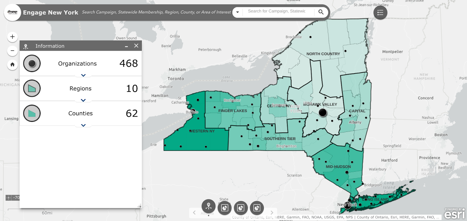
The 10 Engage New York regions are consistent with the New York State Economic Development Regions

One such web map is Engage New York.  Launched in 2021, this interactive map is intended to constitute and visually represent  the Empire State nonprofit landscape which is critical to foundations and nonprofit leaders in supporting community-based initiatives  The initial map included over 300 organizations which categorizes their services as well as identifying the geographic area where they’re located and working.   It is intended to be used by nonprofit leaders and funding organizations to build relationships, strengthen interregional networking, identify geographic gaps in the nonprofit ecosystem and aid place-based nonprofits to find peers and colleagues working on similar issues in other regions of the state. The map is the work of the organization of the same name – Engage New York (ENY).

After reinvigorating the network in 2018 and focusing on issues including immigration and safe and healthy housing, ENY in 2020 moved to support movements and movement leaders throughout New York State that were organizing communities impacted by injustice. Engage New York Program Manager Lisa Fasolo Frishman comments “We know that all of the issue areas are intersectional and it is more important for us as a network to support leaders and movements that are inclusive of voices that are often excluded from advocacy efforts particularly in underserved and rural areas. Census 2020 and redistricting work has been a pivotal area for us because representation matters, and we are committed to ensuring communities impacted by injustice are seen and heard.”

Continue reading

Envisioning the Future of Buffalo’s East Side

AGOL viewer, data HUB, and other geospatial tools used in helping develop WITHIN East Side Plan

Community focused GIS projects are always a favorite of mine to write about.  Highlighting how geospatial tools can be used by community groups – including nonprofits which are often project sponsors – to better help visualize and understand the vast array of environmental, regulatory, business and public health, and cultural data which impacts their daily lives.  One such project located in Buffalo’s east side was brought to my attention in a recent communication with Lisa Matthies-Wiza, Director of Geographic Information Services at Erie County.  

WITHIN East Side

The WITHIN East Side project is one of many projects of LISC Western New York (WNY) and its larger parent organization LISC New York.  program.   WITHIN East Side  focuses on simplifying the neighborhood planning and community development process, and ensures development is driven by resident leaders and community groups.  As an open, inclusive, community-driven initiative, WITHIN East Side brings together neighborhood voices, trusted partners, and supportive funders in an effort to better the wellbeing of residents using their own visions. Together with LISC NY, the WITHIN East Side stakeholders collaboratively identify projects that sustain the positive momentum happening in local neighborhoods.

In early 2020, LISC NY began planning with community partners in three geographic focus areas in the East Side under the WITHIN East Side program.  The East Side of Buffalo, which is the heart of Buffalo’s Black community was chosen as it is purposeful to build upon and lift up the long-time visions of residents and community leaders in neighborhoods most impacted by historic disinvestment, environmental, structural, and systemic racism.  The additional impact of the racist mass shooting on May 14, 2022, that killed 10 people, at a local supermarket within the planning area, furthered the importance of amplifying the community’s voice and vision for the future.

The project was designed as a two-pronged approach–integrating economic development and quality-of-life planning.  Closely intertwined, both  economic development and quality-of-life planning require understanding community history and dynamics, collaboratively identifying projects, building relationships with diverse stakeholders, and turning community priorities into progress.

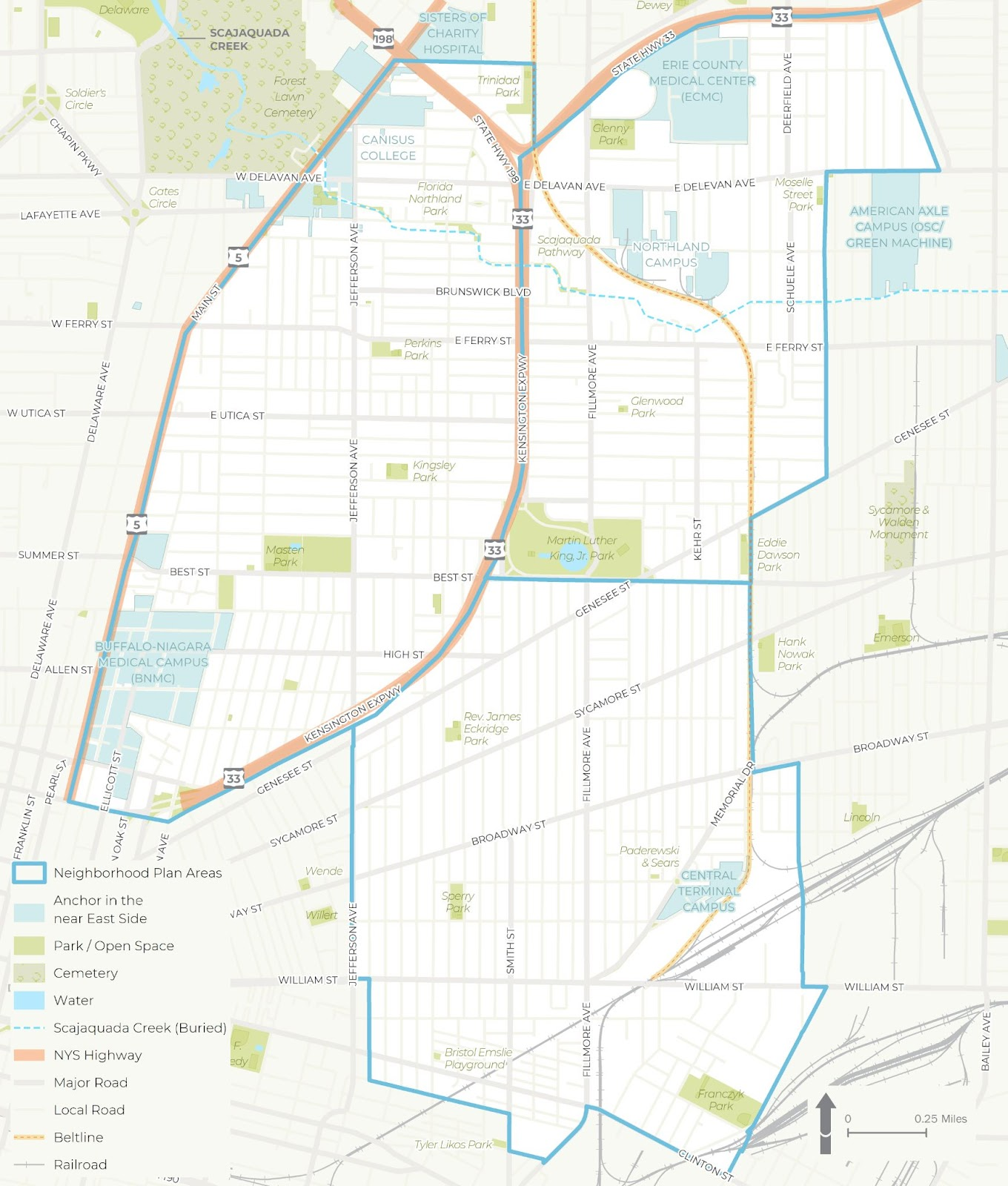
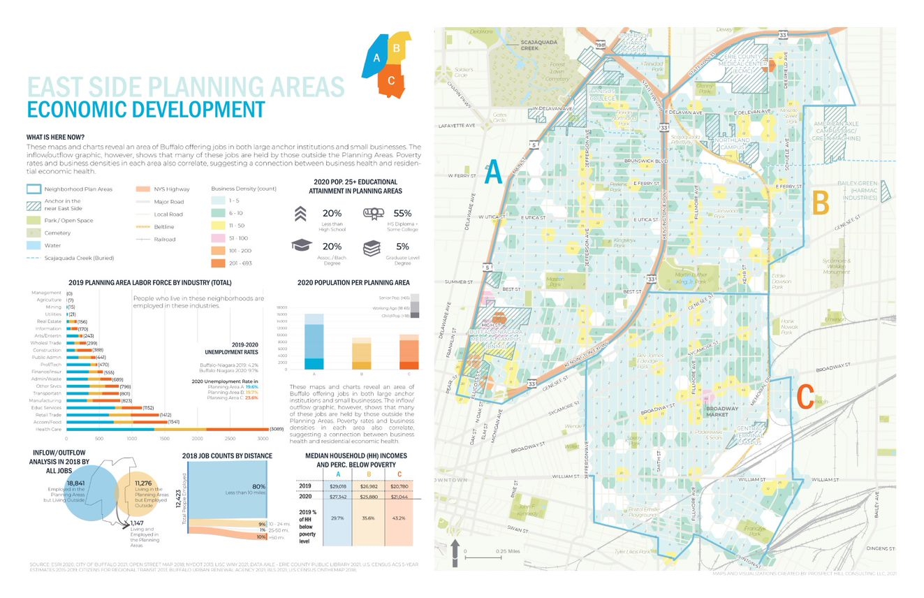
The WITHIN East Side project was broken into three distinct study areas – each of which was studied in more detail for a wide range of demographic, cultural and economic development issues

Background

LISC NY contracted with Prospect Hill Consulting (PHC), a local minority and women owned consulting firm which had responded to a formal Request for Proposals (RFP) which was issued in January 2021.  GIS mapping and analysis was a requirement and the LISC NY team knew GIS services were important to supporting the overall East Side project.  PHC was selected to perform elements A (GIS Mapping [including an online mapping tool request and a data HUB) and B (Scenario Planning).   While LISC NY had a vision of what the final plan might look like,  PHC was instrumental in assisting LISC NY in developing maps and visualizations used in the final plan and in community engagement sessions throughout the process.

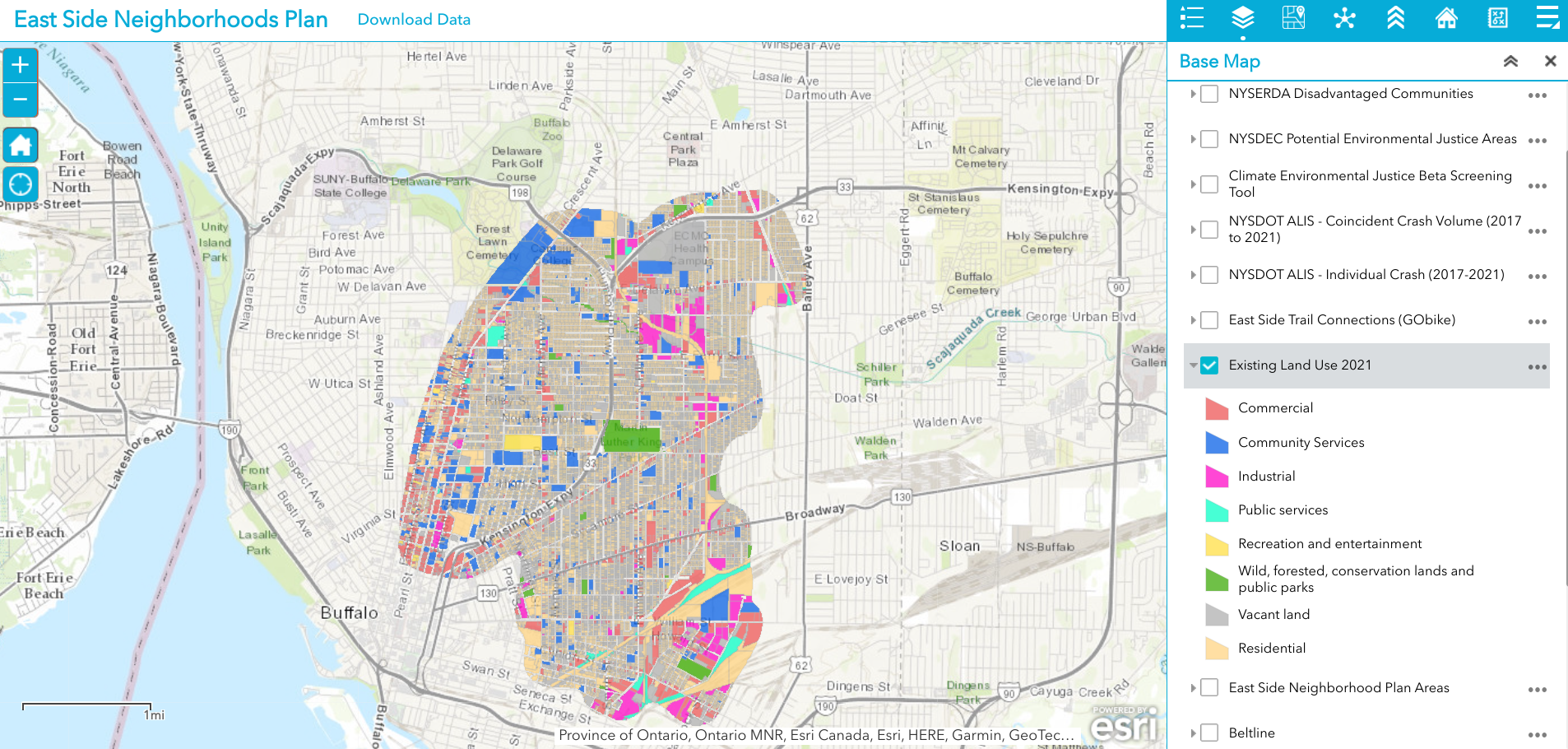
Existing 2021 land use is just one of dozens of data layers in the WITHIN East Side AGOL viewer. The rich database consists of local, regional, state and federal datasets.

Leading geospatial development of the East Side project from PHC was Jenny Magovero, President and Co-founder. Ms. Mogavero has been working in the GIS field for 23 years covering geospatial applications in community planning and environmental sciences as well as work in data visualization and  project management.  Mogavero created all of the maps in the East Side plan using the ArcGIS client as well as for spatial analysis and modeling.  The project web map is ArcGIS Online based with the data stored in a Hub Site (to allow for data sharing) and was designed about halfway through the GIS mapping and analysis task to support the WITHIN planning process itself.

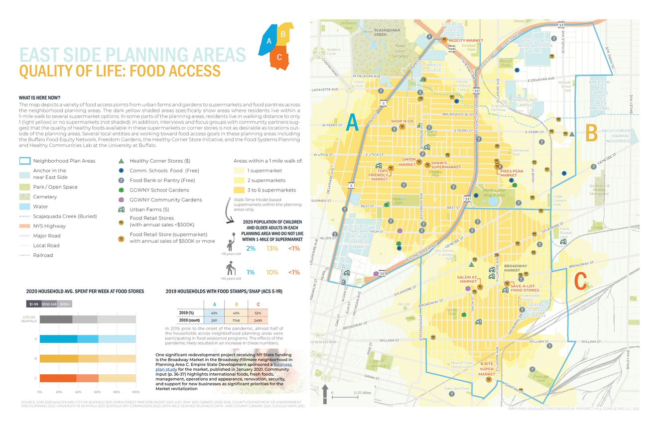
One of the many excellent graphics iWITHIN East Side report. The map on the right identities areas within the study area where supermarkets are located – a significant issue for residents with limited transportation options.

LISC NY wanted to be as transparent as possible and allow stakeholders (i.e. the community/public, organizations, etc.) to work with the data and download and use it if they needed.  To this end, the AGOL interactive map was used in community outreach and meetings early in the project and as new data came online (i.e., stakeholders requested to see additional themes) PHC continued to update the AGOL viewer. PHC designed the AGOL viewer to serve as a communication medium that allowed LISC NY to show project progress, survey the community on what themes needed to be covered and/or identify gaps, and to act as a platform to continue engagement with the community in the future. 

Economic Development issues are paramount in the study such as the role of small businesses, inflow of non-residents that work – but do not live – in the area, as well as the concentration(s) and accessibility of employment opportunities.

Data collection and development was specific to the mapping and analysis that the LISC NY team needed for the WITHIN plan itself.  As LISC NY has significant business relationships within the greater Buffalo community, they were able to collect a lot of data from local, state and NGOs. In addition, PHC collected publicly available data from the City of Buffalo, Erie County (parcels, land use, etc.), New York State  (NYSDEC, NYSDOT, etc.) and federal datasets (EPA, Census, etc.).  Additionally, PHC developed data from reports or datasets that were anecdotally described by stakeholders (like the air quality buffer, buried portions of the Scajaquada Creek, key intersections, etc.).  Project data was also obtained from utilities, Google, OpenStreetMaps, and ESRI.  

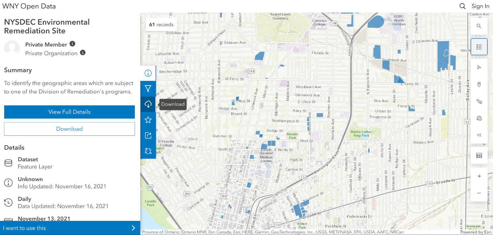
Most of the project data is made available through the LISC WNY Open Data Hub which was also designed and continues to be supported by PHC.  (Some providers did not want their data to be shared so it is only available for viewing in the application.)   

No AGOL account is necessary to access the HUB and tags help users to easily jump to specific themes of data presented in the final plan for download.

PHC used a bevy of GIS,  statistical packages, and desktop publishing software tools to generate the maps and graphics in the report including: 

  1. ArcGIS Online to collect stats for the neighborhood that were ACS 5yr census based (https://doc.arcgis.com/en/arcgis-online/analyze/enrich-layer.htm)
  2. Geospatial processing tools to buffer, clip, summarize, and run overlay analyses
  3. Spatial Analyst tools to develop walkshed layers (from points provided by Walkscore)
  4. Tableau Desktop and Excel to conduct data exploration to emphasize trends (or data insights) with graphs/visualization on  map layouts
  5. Adobe InDesign for page layouts and other graphics to be consistent with the LISC NY brand book (design guide) including colors, fonts, and logos.
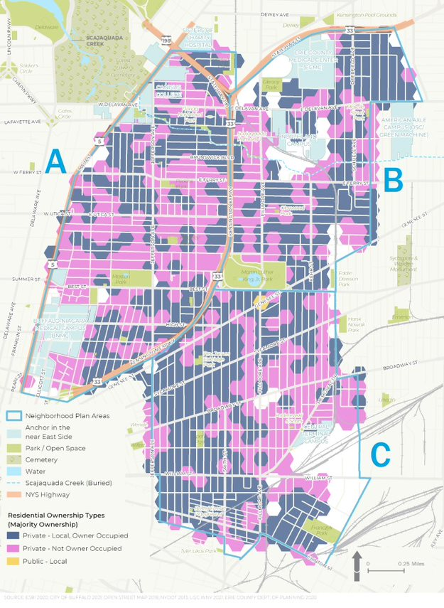
  6. ESRI’s Hexagon sampling tool to visualize parcel data classes (i.e. land use, vacant parcel density, ownership) at the scale of the plan areas. 

Residential ownership type is an important variable in urban studies. Data presented in the figure above suggests there continue to be many opportunities in increasing owner occupied properties in the study area

Summary

While consulting architecture and engineering companies continue to expand their geospatial offerings to governments and regional programs in 2022, particularly in the infrastructure and public works space, planning firms such as PHC serve in a unique space focusing on efforts which include applying geospatial tools as part of important community-based projects which often include significant public input and involvement.  Tools such as AGOL provide a great  framework in which to engage the public with regard to adding and removing data content and visualizing potential scenario outcomes.  A particularly useful tool given the enormity of the data used in the WITHIN East Side plan.

Reflecting on PHC’s involvement in the study, Jenny Mogavero notes:

“LISC NY is an integral part of, and key economic engine within the Western New York region.  Prospect Hill was honored to partner with the LISC NY to use GIS data, visualization tools and spatial analysis methods to not only present the existing conditions of our city’s East Side neighborhoods, but also reveal the deeper insights that occur when we overlap data-driven stories across multiple thematic lanes.  We were thrilled that our work supported the teams’ consensus building goals to develop a vision of a prosperous future for an important part of our City.”

Tyra Johnson Hux, WNY Director of Operations, also reflects on PHC’s work and the use of geospatial tools in the project adding:

“WITHIN East Side amplifies the visions of residents and community leaders in neighborhoods impacted by historic disinvestment, environmental, structural, & systemic racism. Showing their stories through, not only their own words, but also data was critical to helping our stakeholders generate a bold, authentic and comprehensive vision with an emphasis on implementation.  PHC supported the WITHIN East Side Plan by working with the project team to identify, collect and normalize relevant GIS data from neighborhood, government, academic and other partners. Additionally, they worked with us to analyze and visualize the community experience through maps and infographics.  The online interactive map and data warehouse they developed made it possible to share data in a way that breaks down silos, facilitate  strategic planning and continue community conversations.”

Contact

Jenny Mogavero, GISP
Prospect Hill Consulting LLC | Principal
716.432.9053 | www.prospecthill.co
jmogavero@prospecthill.co

Lashay Young, Director
External Affairs for LISC NY
https://www.lisc.org/
LYoung@lisc.org

Mapping a New Economy for Equality and Sustainability

New York City nonprofit uses GIS to help support cooperative and community-led development projects as well as advocacy campaigns

Introduction

Nonprofits are one of my favorite areas to cover in the geospatial space.  More than not their geospatial efforts operating on a shoestring budget, relying mostly on filtering through open data portals and mashing everything together to create visual products with open source software or via discounted vendor supported nonprofit software licensing agreements. Its not uncommon to find the person(s) doing spatial analysis and map making having been self-taught.  A lot gets done with a little.

One such organization is the New Economy Project (NEP) located in New York City.  NEP works with community groups to build a new economy that works for all, based on principles of cooperation, democracy, equity, racial justice, and ecological sustainability.  Their focused campaigns are carried out in concert with community, labor, civil rights and social justice groups on initiatives such as:

  • Public Bank NYC, a municipal public bank campaign rooted in economic and racial justice. Through public banking, NYC can divest from Wall Street banks, reinvest public deposits to support equitable and cooperative development.  
  • Advancing Community Land Trusts, through co-leadership of the NYC Community Land Initiative (NYCCLI) and one-on-one work with community groups seeking to organize community land trusts. 
  • Advancing NYS Community Equity Agenda, calling for transformation of the fundamentally unjust social, political and economic systems. The Equity Agenda puts racial and economic justice front and center and addresses long-standing inequities that play out at neighborhood and regional levels. 
  • Growing NYC’s Cooperative Economy through coalition-building and policy change that supports and brings together community land trusts; worker, housing, financial and food co-ops; and other models of cooperative, community-led development.

GIS and Mapping

Behind all of the mapping at the New Economy Project is Ben Hagen who currently serves as Senior Research and Communications Associate.  “As much of our work focuses financial services, a considerable amount of our data comes from the Federal Deposit Insurance Corporation (FDIC)” Ben notes, “and more specifically from the Summary of Deposits section.”   Ben does all of his mapping and data analysis with ArcMap having learned the craft as part of his graduate work in Urban Planning at New York University.  Other data sources frequently used by NEP include the U.S.Census Bureau, New York State Department of Financial ServicesNew York State Office of Court Administration, and NYC OpenData. 

NEP uses use ESRI’s World Geocoding Service to support most of its address mapping though in the past had also used the city’s LION file. In addition to ArcGIS, the main other data-related software NEP uses is open source software R for cleaning data, especially when preparinfor for mapping. Hagen likes R software because it runs on text-based code and is great for replicating processes with minimal opportunities for introducing errors, as well as for easily sharing with others for a second look at methodology.  

Samples of NEP mapping products include (click image for map download).

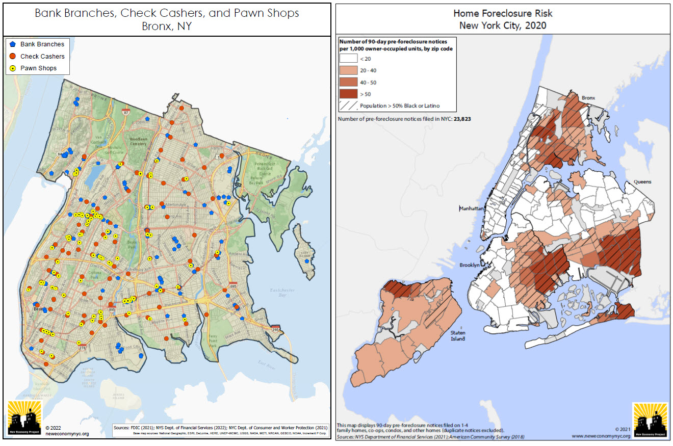
(Left Image): Bank branches are not distributed and made accessible evenly across the city.  This map depict the relative absence of bank branches in  the Bronx, and the resulting concentration of high-cost alternatives such as check cashers and pawn shops. This is a series of maps that NEP updates every year covering most (if not all) of the city’s neighborhoods.  (Right Image): NEP creates maps showing the concentration of residential foreclosure risk in NYC communities of color. This uses data from the NYS Dept. of Financial Services, based on notices that mortgage servicers are required to send to delinquent borrowers 90 days before initiating a foreclosure action. While not all of these notices result in an eventual foreclosure, it provides a good indication of where the risk of home foreclosure is highest in the city.

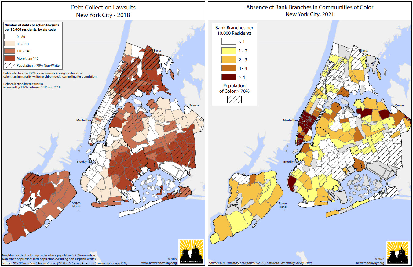
(Left Image): Using data from the NYS Office of Court Administration, this NEP map highlights the concentration of debt collection lawsuits in communities of color and is included in this report prepared for AARP New York.  For additional maps, graphics and YouTube videos on this project visit this web page.  (Right Image):  Another map showing the relative absence of bank branches in NYC’s communities of color. Looking at this annually, one can see changes as gentrifying neighborhoods gain branches, but the overall pattern is a long-standing and remarkably stable one. There are actually six zip codes in the city, ranging in population from about 20,000 to 94,000 and all in communities of color, that have no bank branches at all.

Other examples of NEP research and mapping products can be viewed here.

Summary:

The concept of “place” has always been at the core of how we approach our work” notes Hagen.  “In NYC, people feel very connected to their neighborhoods, and are acutely aware of how much the communities they call home shape their day-to-day lives. There’s no better way than maps to relate to people’s experience of their physical environment, and to help contextualize those environments within the larger, systemic frameworks that we are so often fighting to change.

Clearly, GIS is both an important business and commuication tool for NEP.

Contact:

Ben Hagen
Senior Research and Communications Associate
New Economy Project
121 W. 27th Street #804 | NY, NY 10001
212.680.5100, ext. 221 | neweconomynyc.org


NYC H2O: Advocating Cleaner Water through StoryMaps

NYC-based nonprofit has developed extensive portfolio of educational products for all ages and settings

StoryMaps are such a great communication tool.  Turning geographic and location-based features and concepts into an easy-to-understand medium for the much broader audience which help identify key community resources, assets and experiences that can inform planning and policy-making.  By combining narrative text and other multimedia content with Geographic Information System (GIS) maps and data, story maps serve as an effective means of helping residents and developers visualize and understand projects with greater clarity.  Increasingly becoming an art form unto itself.  Broadly and increasingly used across the geospatial spectrum from the industry-leading ESRI StoryMaps platform  to say the least of the versions being offered by others in the geospatial space including Google Earth, CARTO, or Tableau

I’m sure its not the first time Story Map subject matter has found its way to be included in a more technical oriented conference, but I was nonetheless interested, if not surprised, to see a presentation by NYC H2O at the recent the September 9th New York City Watershed Science and Technical Conference.   A conference historically the home for geospatial-based technical and scientific presentations by engineers, biologists, and others in the water science disciplines, NYC H2O’s presentation was entitled Engaging an Urban Population With Water Engineering Utilizing a Virtual GIS Platform in the Pandemic Era”.

Having received its nonprofit 501(c)(3) designation in May, 2012, such work is not new to NYC H2O as it has built a niche in the environmental education space using the Story Map platform as its primary teaching and outreach tool. Story Maps augment and support their mission to “inspire and educate New Yorkers of all ages to learn about, enjoy and protect their city’s local water ecology.  Since 2009, NYC H2O has offered over 120 educational programs focused on NYC’s water system and ecology to a combined audience of 4,000 people.  Their StoryMaps often incorporate  digitized historic maps, photographs, videos, and social narratives to tell the story of waterrelated  infrastructure.

A couple of NYC H20’s StoryMaps in the water sciences and environmental space include:

Water Systems Overview

I’ve often heard the New York City aqueduct system referred to as the “eight wonder of the world”.   Maybe not as sexy and visible as the Great Pyramid but an incredible engineering marvel nonetheless.  Conceived, designed and built in another era to support the drinking water lifeline of the city

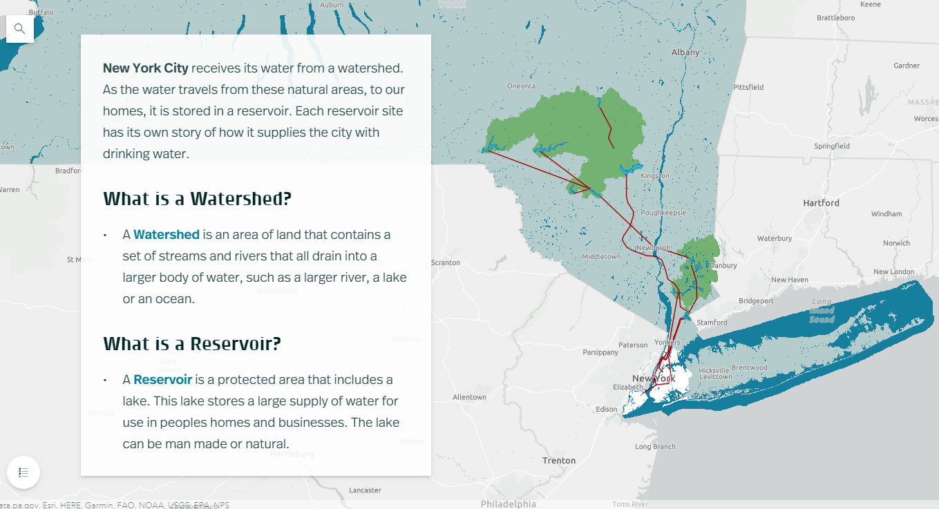
NYC receives 90% of its water from the Delaware and Catskill Watersheds. Aqueducts (red line work) transports the fresh water from a series of reservoirs in the Catskill Mountains over 100-miles from the city.

Fitting that the first StoryMap posted by NYC H2O on their “Hub” website is entitled  Water Systems Overview outlining and showing the many geographies of the system which originates in the Catskills Region.  An interactive StoryMap highlighting the major aqueduct systems (Catskill and Delaware – named for the watersheds where the water is collected), as well as the individual reservoirs both upstate and those in the city.  Household water consumption stats are also included in the StoryMap as well as several interactive learning activities as illustrated in the application toolbar below.  Included in the Site Specific Lessons is a StoryMap just for High Bridge and the Jerome Park Reservoir.

Sewer System and Stormwater Management

This StoryMap, focusing on the relationship between storm water and sanitary sewage, and its overall impact on water quality in the metropolitan region has lots more maps and associated data.

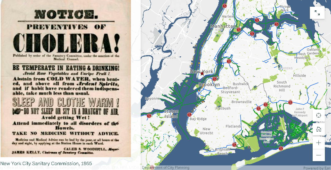
Beginning in 1850, NYC laid 70 miles of sewers, or underground pipes that carried away wastewater.   Today the city has over 7,400 miles of sewer pipes. These pipes move wastewater with the help of 95 pumping stations to 14 sewage treatment plants located in all five boroughs.  Each day, NYC wastewater treatment plants process, or “clean”, a total of 1.3 billion gallons of wastewater.   Produceing about 1,400 tons, or 60 truckloads, of biosolids!

The city maintains 14 sewage treatment plants covering the five boroughs. Treated sewage effluent is discharged into the Hudson and East Rivers and Long Island Sound.

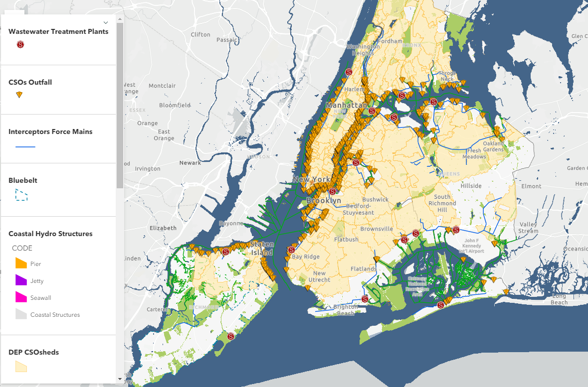
About 60% of New York City’s sewer system is a combined sewer system. This means that one single pipe carries both stormwater runoff AND sewage from city buildings.  During heavy rainstorms, combined sewers systems receive more stormwater runoff and sewage. Wastewater Treatment plants have a capacity, or a limit, to how much water they can clean. When there is more water than the capacity, a mix of stormwater and untreated sewage empties directly into the City’s surrounding waterways. These wet weather events are called combined sewer overflows (CSOs).

The presence of combined sewers are still very prevalent in the metropolitan region with the majority emptying into the East River and the east side of the Hudson River.

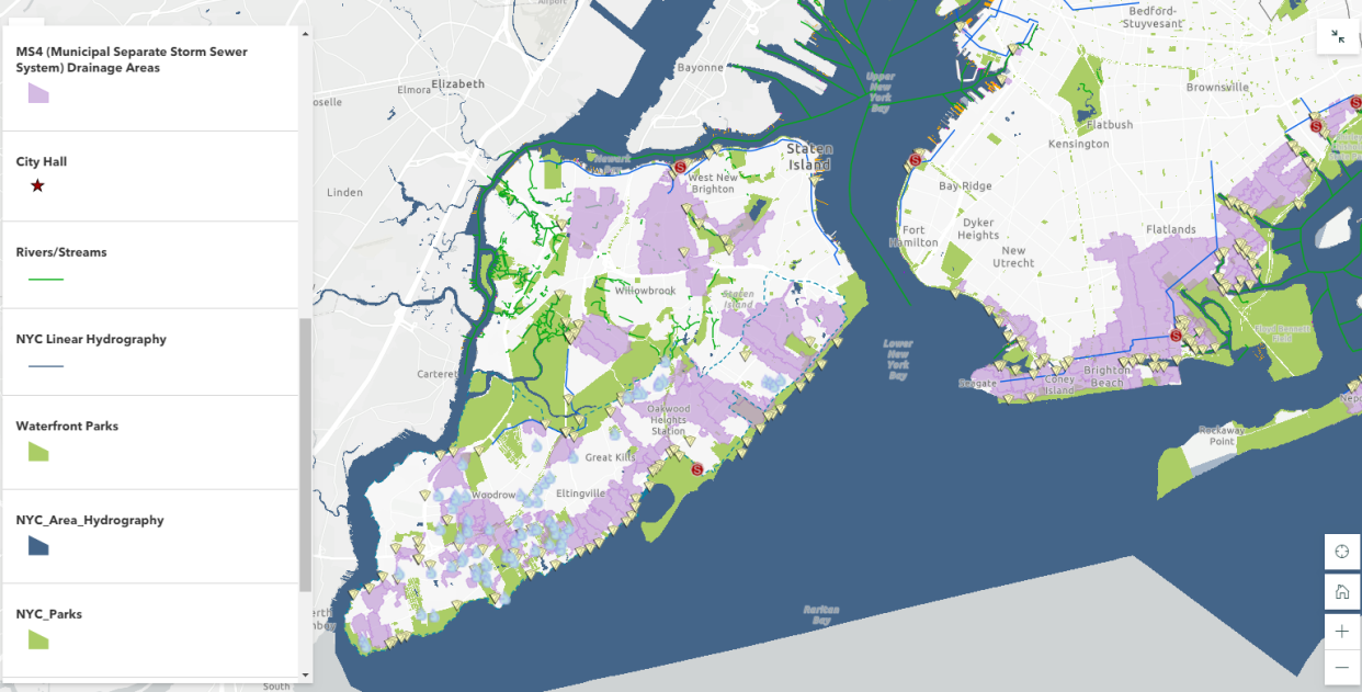
Also central to the long term management of clean water – are government regulated programs entitled Municipal Separate Storm Sewer System (MS4) programs.  In populated areas many neighborhoods, including in New York city, as well as industrial areas along coasts, have deployed MS4 programs.  A MS4 has one set of pipes that transports sewage to sewage treatment plants and another set of pipes that transports stormwater directly to local waterways.   Unfortunately, many pollutants (like oil, trash, pet waste, pesticides, and fertilizers from lawns) are washed into this system when it rains. MS4 helps solve one problem (CSOs and sewage in the local waterways) but causes a similar, although smaller, problem since trash and pollution can still enter the local waterways when it rains.

Currently, only about 40% of the NYC footprint is covered by an MS4.

As it relates to the collection of data for the purposes of monitoring citywide water quality, this StoryMap also includes interesting map displays of both fecal coliform (1985-2017) and dissolved oxygen (1909-2017) testing.

Summary:

It’s nice to see as part of such advocacy efforts the use of open data sets and geographic content as made available by government agencies and data portals.  Much of which is included in many of the 21 StoryMaps listed on the NYC H2O HUB.

StoryMaps allowed us to keep students engaged in learning about their local water issues throughout the challenges of the pandemic. The tool has been so popular with schools that this year we launched a curriculum introducing GIS and StoryMaps to several environmental science and environmental justice in high school classrooms”, notes Kevin Barrett who guides NYC H2O’s mapping instruction.

With regard to the September 9th New York City Watershed Science and Technical Conference, Stalin Espinal, School Program Manager for NYC H2O adds “The conference gave us the opportunity to share our work and programs to a community of our peers. We were delighted to have received such enthusiasm and interest in our work with GIS and StoryMaps.  Even resulting in a new StoryMap collaboration in partnership with the Watershed Agriculture Council (WAC) which works with local farms on and around the upstate New York City watershed to promote Best-Practices and make improvements that help protect the water quality of our drinking water.”

Contact:

Kevin Barnett
GIS Education/Project Manager
kevin@nych2o.org
www.nych2o.org

10 Questions: Ken Stewart, NUAIR

Northeast UAS Airspace Integration Research Alliance
Ken Stewart is currently Chief Executive Officer of NUAIR (Northeast UAS Airspace Integration Research Alliance, Inc.) located in Syracuse, New York.  NUAIR is a New York based nonprofit organization that provides expertise in unmanned aircraft systems (UAS) operations, aeronautical research, safety management and consulting services.   He joined the organization in late 2020 where he is responsible for setting the overall vision and product strategy for the organization.  Mr. Stewart is an experienced industry veteran in wireless telecommunications and cloud-based software market with a specialization in building Enterprise SaaS, Federated digital marketplaces and platforms.

Prior to joining NUAIR,  Mr. Stewart served as the CEO of AiRXOS, a General Electric aviation company, where he led innovation, development, and commercialization of Unmanned Traffic Management services.  After beginning his career in engineering and management positions at IBM and GTE, Stewart served as an executive with several venture capital and private equity-backed companies commercializing and scaling pre-revenue start-ups and transforming organizations for growth.

He was recently appointed president of the Commercial Drone Alliance (CDA) which is an independent nonprofit that works with all levels of government to collaborate on policies for industry growth and the overall responsible use of commercial drone technology.

I was recently able to catch up with Ken and NUAIR staff to discuss his work in the drone space in New York State.

eSpatiallyNewYork: What is the primary function and purpose of NUAIR?

Stewart:  NUAIR is responsible for the continued development and advancement of New York’s AAM Proving Grounds and 50-mile UAS corridor between Syracuse and Rome, facilitating beyond visual line of sight testing, commercial operations, and the safe integration of UAS and eVTOLS into the national airspace.  Here’s a link to some of the history of how everything got started: https://esd.ny.gov/central-ny-rising-uri

NUAIR also manages operations of the New York UAS Test Site at Griffiss International Airport in Rome, NY, one of just seven FAA-designated UAS test sites in the United States and is responsible to the Federal Aviation Administration (FAA) and National Aeronautics and Space Administration (NASA) to conduct operations for UAS and advanced air mobility (AAM) eVTOL (electric vertical takeoff and landing testing).

eSpatiallyNewYork:  NUAIR seems to be mostly New York State-based.  How does its function and purpose differ from CDA? 

Stewart:  We continue to conduct meaningful projects and tests in New York for the FAA, NASA, and industry to advance both the UAS and advanced air mobility (AAM) industries. These projects provide the needed data to prove the safety and reliability cases to help shape policy and regulation to unlock the true potential of commercial drone operations. I am taking my professional expertise, coupled with the knowledge of the 3,600+ UAS test flights NUAIR has conducted at the New York UAS Test Site to help generate the needed policies and regulations to make national commercial drone operations both scalable and economically viable. I also represent NUAIR on the FAA beyond visual line of sight (BVLOS) advisory and rulemaking committee (ARC), actively working with the FAA and fellow industry leaders to solve the issues around safely flying BVLOS. Being a part of both of these initiatives gives NUAIR the ability to directly influence and shape the future of aviation.

eSpatiallyNewYork:  Can you share some examples of NUAIR  providing outreach and consulting to governments in New York State on drone use and/or technology?

Stewart:  NUAIR has helped over 20 state agencies implement their drone programs including law enforcement, fire departments, environmental conservation and more. Selected examples are highlighted in this YouTube video.

We’ve also just started working with the New York State Thruway Authority, helping them integrate drones into their daily operations for routine bridge and infrastructure inspections. Flying a drone to scan a bridge is a lot safer than the traditional means of using a snooper truck, both for the crew inspecting the bridge and for motorists. Couple that with faster, more cost-effective inspections, it’s a win-win for the crew, the local economy and New York State as a whole.

eSpatiallyNewYork:  Would appear a lot of this work is in the public safety community.  Are there other areas of government?   

Stewart:  The healthcare industry is beginning to realize the benefits of utilizing drones as well, especially the ability of contactless delivery of materials. You can read here about one of our recent collaborations with SUNY Upstate Medical where we helped deliver unused COVID-19 Test Kits.

eSpatiallyNewYork:  Explain NUAIR’s relationship with the start-up incubators Genius NY and The Tech Garden. 

Stewart:  GENIUS NY and The Tech Garden are key partners and organizations for the Central New York UAS and high-tech ecosystem. We work directly with many of the companies in the Tech Garden and actively promote the resources both organizations provide to tech startups, actively contributing to the economic development of the region. Our COO Tony Basile is also on the board of directors for GENIUS NY, actively reviewing applicants and voting on the winners.

eSpatiallyNewYork:  The NUAIR Alliance is impressive.   How do these categories stack up in New York State? 

The NUAIR Alliance continues to grow on a global scale and includes organizations from all aspects involved with UAS and technology including policy & standards, spectrum, test sites, components, government and more. Visit https://nuair.org/alliance/ to see all of our active Alliance members.

NUAIR and the New York UAS Test Site has brought over 330 different companies from across the world and thousands of people to Central New York throughout the years and continue to bring in companies to test and setup shop.

eSpatiallyNewYork:  FAA, NASA Aviation, and state/local drone regulations – how does NUAIR stay on top of all the changes?  It all seems so fluid, dynamic, constantly changing.

Stewart:  This is what we do all-day, every-day. NUAIR employees are talking with, working with and/or conducting meaningful projects the FAA, NASA and industry every day of the week.

eSpatiallyNewYork:  How’s the industry dealing with all of the security concerns over Chinese made drone products such as the DJIs?  How are US-based companies responding in this regard?  

Stewart:  The concern with Chinese/foreign made drone and components continues to grow, including the recent regulations from the United States government stating that federal funds cannot be used to purchase Chinese (or other specific foreign countries) drone components. A lot of the public safety officials we work with are now looking into one of our partners, Skydio, an American drone manufacturer, who was a major hit at the New York Public Safety UAS Summit we just held. We’ve also validated a drone parachute on the WorkHorse, an American-made UAV built for deliveries.

eSpatiallyNewYork:  Any involvement / business development with the any GIS companies?

Stewart:  We have quite an active program with Cardinal Geospatial, trying to define an analysis tool that could be used to determine whether an operator was using a DEM with enough granularity for their mission and the terrain over which they are flying.

eSpatiallyNewYork:  Looking into the crystal ball, what’s the next big thing for the upstate drone/NUAIR community? 

Stewart:  5G. MITRE Engenuity Open Generation Consortium has determined New York’s 50-mile corridor is a prime location to launch the nation’s first 5G UAS testing range, a designation that will greatly enhance New York’s position as a global leader in this emerging technology sector.

The work we continue with the FAA, NASA, and industry both on the standards/regulations side and the physical data collection/testing side are helping shape the future of aviation. This work will unlock the true potential of drones for commercial operations that are both scalable and economically viable. The drone and overall high-tech Central New York ecosystem has everything a company needs to land and expand their UAS operations.

Contact:

Tim Lawton
Director of Marketing & Public Relations
tlawton@nuair.org
www.nuair.org

Hub2Hub: Sharing and Promoting the Geospatial Message

Publishing spatial data content has proven to be great outreach in terms of providing transparency and exposure for many government GIS programs – including here at Westchester County.  Increasingly much easier for geospatial organizations to do courtesy of powerful server technology allowing these same agencies to easily spin together data services based on common thematic features such as environmental, planimetric, business, demographics, cultural, parcels, and aerial photography to name only a few.  Though the data service environment is better understood and leveraged by a specific user community knowing what type of spatial content to look for, there remains even a larger community of geospatial users which navigate data portals to download just individual data sets.  Looking for that individual shapefile, KML, or .dwg file for their own individual project.

And even with all of this good geospatial content available, many publishing organizations – particularly government – struggle with building educational outreach programs for the larger GIS user community.  Tailored programs for users in community and advocacy groups, nonprofits, and even the business sector instructing how to effectively use and leverage our data.  Government GIS programs often do not have the resources or the business model to deliver these types of services outside of their organization.

Enter the emerging roll of “service” Hubs which specialize in leveraging government open data  in ways government programs normally cannot offer. Some are nonprofit in nature or affiliated with academic institutions.  Others, like OpenHub based in the lower Hudson Valley, is a for-profit venture.  The common theme among them is a window offering a wide range of engaging programs increasingly based on government data sets featuring hackathons, workshops and training programs,  application tools, and offering  business tech “round table-type” discussions.  While open source software such as OpenStreetMap, QGIS, Python, and R are commonly used to support their missions (and thus, the easy and affordable entry point for new users), one can see the use of ArcGIS Online and CARTO being offered as well.  Effectively expanding the use and understanding of geospatial concepts and bringing technology to the people.

Third Party “Hubs”

I’ve referenced and written before on the great work of BetaNYC serving in this space.  Particularly with regard to extending content of NYC OpenData  through their numerous programs including the flagship NYC School of Data conference.  While New York City does an incredible job in promoting and maintaining city government’s open data catalog itself, BetaNYC extends the effort by building an entire framework of putting the data into the hands of residents on the streets.

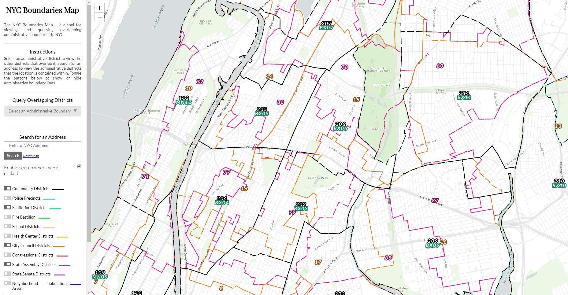
This BetaNYC viewing applications enables user to navigate the numerous political, administrative, and operational districts across New York City

Early in this space in the metro NYC area was the work of Steve Romalewski who started providing mapping services to the nonprofit sector as part of the Community Mapping Assistance Project (CMAP) which at the time was affiliated with New York Public Interest Research Group (NYPIRG).  Since 2006 he has been affiliated with the CUNY Mapping Service as part of the Center for Urban Research, Graduate Center at City University of New York (CUNY).

The Long Island Index was an early and very visible project that the CUNY Mapping helped create.  Another effort affiliated with the Center is the NYC Labor Market Information Service uses federal business and labor data sets.  Be sure to check out their Career Maps infographics and reports.  Similar academic efforts in the city exist at the Spatial Analysis and Visualization Initiative (SAVI) at Pratt Institute and the Center for Spatial Research at Columbia University.

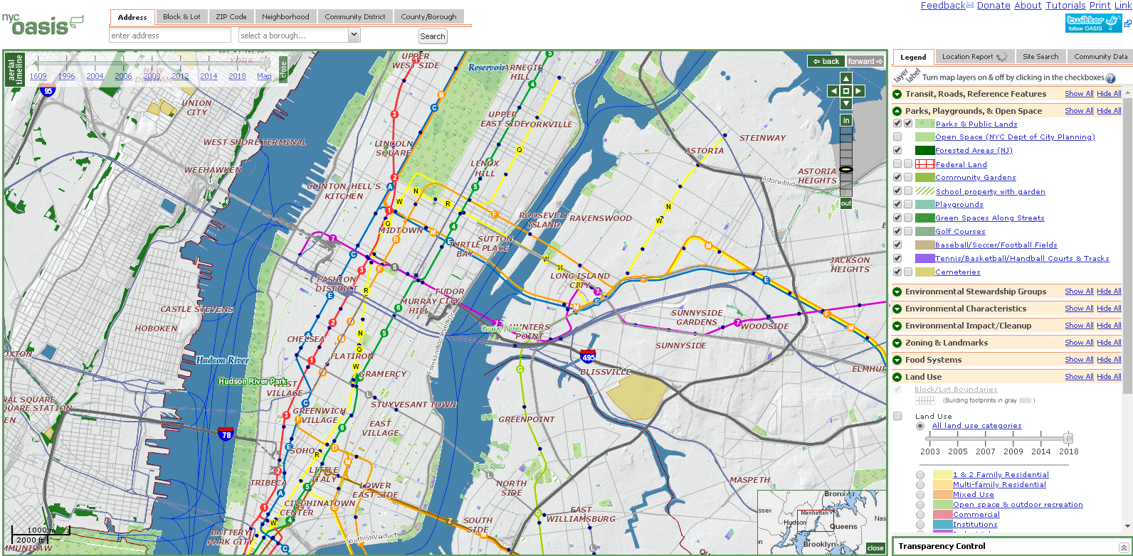
Though originally developed at CMAP, the CUNY Mapping Service now hosts OASIS which is one of the most comprehensive mapping and viewing application covering the New York City footprint. Dozens of government generated datasets are made available in the viewer.

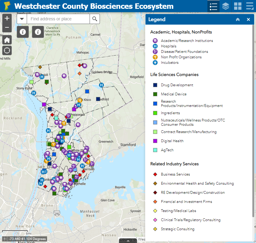
While the OpenHub is only beginning to jump into the geospatial space, its Founder Yulia Ovchinnikova will be highlighting the Westchester County GeoHub as part of the 2021 HV TechFest Conference as an example of open government and open-source data sharing to promote building communities. OpenHub will also be using content from the county’s GeoHub as part of a course project during a current online Data Analytics Bootcamp.  As regional technology and economic development is an important focus to OpenHub’s mission and purpose, our discussion started by focusing on a new web map being published which highlights the emerging BioSciences Ecosystem community in Westchester County.  The County is home to the largest biosciences cluster in New York State, boasting 8,000 jobs and 20 percent of the State’s total biosciences employment. The cluster comprises academic institutes doing basic research, R&D and clinical stage startups, large manufacturers and supply chain participants. OpenHub offers a mixture of both free and fee-based online programs including coding clubs, meetups, programming, and specific events for small businesses and startups. OpenHub is an open ecosystem resource center committed to building a tech-sector in the Hudson Valley and beyond

Government open data and economic development. BioScience business location X,Ys are available for download via ArcGIS Online.

MANY organizations leverage government generated geospatial data to support their own business needs and/or to champion a host of civic needs and issues.  In just one area, such as environmental justice (EJ), a Google search located a document published by the SeaGrant program at SUNY Stony Brook which identifies the numerous individual agencies (largely government and nonprofit) engaged in providing “Environmental Justice Mapping Tools for New York State Communities”.   Child care, social services, public safety, public transportation, sustainability, climate change, and civic issues only scratch the surface of the spaces where advocacy groups are involved in using government geospatial content for the larger public good.

Summary

What differentiates the groups itemized above are that they are more full service, a la carte organizations offering a wider range of products and services.  Staffing and resources to turn government data content into meaningful deliverables such as workshops (online and in-person), hackathon-type events, community events,  training courses, and even bringing the data to civic leaders and administrators in ways which is simply not possible by government publishing agencies.  Such outreach is often very targeted making the data more meaningful and ending up in the hands of those who understand its content the most.  Viewing and using the data at the “micro” as opposed to the “macro” or a larger geographic footprint.  Local is better.

While technically not all “hubs” in name, these groups continue to illustrate the growing benefit of how organizations are adding value and exposure to the government data assets.  In many scenarios, building partnerships with these types of service organizations can be of great value to government publishing agencies.


Geospatial Business Spotlight: Adirondack Research

Location:                      Saranac Lake, New York

Website:                       https://www.adkres.org

Employees:                  3 Full-Time / 6 Seasonal

Established:                 2012

The Company

Adirondack Research is a small business located in Saranac Lake which focuses on building expert-backed and science based geospatial solutions.  Currently the firm’s primary focus is on applications and work involving invasive species, climate change, and socio-economics.  Adirondack Research staff includes GIS specialists, web developers, and field technicians and the company produces a retail line of recreation and way-finding maps under the brand Green Goat Maps.

Geospatial software used inside the company  includes ArcGIS Pro on the desktop and ArcGIS Online for a variety of web maps and viewers.  Field data collection is also supported by ESRI tools including Collector and Survey123.  For hardcopy map production both, Adobe Illustrator and Adobe InDesign are used.

Adirondack Research’s Director is Ezra Schwartzberg who received his undergraduate degree from SUNY College of Environmental Science and Forestry (ESF),  graduate degree from University of Kentucky, a doctorate in Entomology  from Penn State and additional post-doctorate work at the University of Wisconsin.

To date,  Adirondack Research clients include the U.S. Forest Service, Adirondack Council, Lake Placid Land Conservancy, Food and Agriculture Organization of the United Nations, U.S. Department of Agriculture, ADK Action, the New York State Department of Environmental Conservation which it has contracted for several invasive species projects, and others.   While most of Adirondack Research’s work is focused in New York State and across New England, their work has taken the firm to Lebanon as well as assisting to the development of a science curriculum for elementary schools in China.

Geospatial Products and Services

  • Environmental mapping using geographic information systems (GIS)
  • Biological inventories
  • Field experiment logistics
  • Ecosystem services assessment
  • Long-term ecosystem monitoring
  • Invasive pest management planning and analysis
  • Comprehensive management plans
  • Public outreach and stakeholder engagement
  • Citizen science
  • Grant writing
  • Expert witness testimony

Schwartzberg uses research expertise to guide processes, including program design, data analysis and project evaluation.  By combining ecological research with print and digital media, Adirondack Research is able to communicate science to help our clients reach their policy goals.

Illustrative projects include:

Surveying Adirondack Lakes for Invasive Species

Over the past several summer field seasons of 2018 – 2020, Adirondack Research was contracted by the Nature Conservancy’s Adirondack Park Invasive Plant Program (APIPP) to survey lakes throughout the Adirondacks.  Data collected during these surveys was used to produce individualized lake maps of aquatic invasive species (AIS) distribution. Objectives for these efforts were twofold:

  1. Detect and delineate any new or existing invasive plant or animal infestations within prioritized lakes.
  2. Utilize a Lowrance ELITE-7Ti fishfinder to map the vegetation beds, contour lines and bottom substrate hardness of a select set of those lakes as a way to gather important data on plant distribution and other physical parameters that influence aquatic plant invasion.

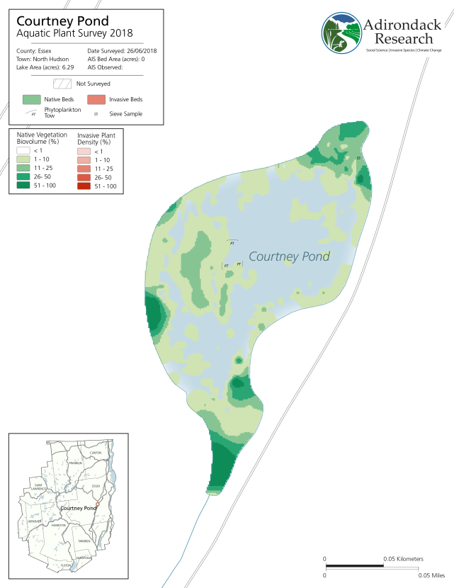
In 2018, Courtney Pond in Essex County was the first year this pond was surveyed and no AIS  detected.

Mapping invasive plant beds is accomplished using a suite of software and hardware tools including GPS, sonar detecting units, C-Map by BioBase, and ArcGIS Pro.  Data from sonar units such as Lawrance Fishfinders can be translated using third party software platforms, including C-Map BioBase and ReefMaster into a format which can be interpolated with ArcGIS Pro to create visualizations of the lake bottom.  This enables staff to assess exactly where an AIS infestation is located within a larger bed of native plants and useful overtime to monitor AIS beds and their spread.  Raster layers generated as part of the work flow are then used to generate maps in ArcGIS Pro and Adobe Illustrator for final reports.  The 2019 report is complete with maps of all lakes or ponds surveyed and can be downloaded here.

Additional information on this and similar Adirondack Research invasive species projects, visit this page.

Lake Placid & Saranac Lake Winter Trails Map

While Adirondack Research makes maps for a variety of purposes to support  geospatial analysis,  ecological species distributions and for land acquisition and conservation easements, the firm also produces a line of recreation and way-finding maps under the brand Green Goat Maps.

As part of this effort, Green Goat Maps emphasizes responsible recreation and environmental stewardship by partnering with organizations to promote principles like Leave No Trace.  Maps also make reference to the proper etiquette for publicly accessible trails, how to prevent the spread of invasive species, and information and regulations specific to the areas covered in each map. Green Goat Maps has  partnered with organizations such as Barkeater Trails Alliance, the Adirondack Land Trust, and The Nature Conservancy Adirondacks in these efforts.

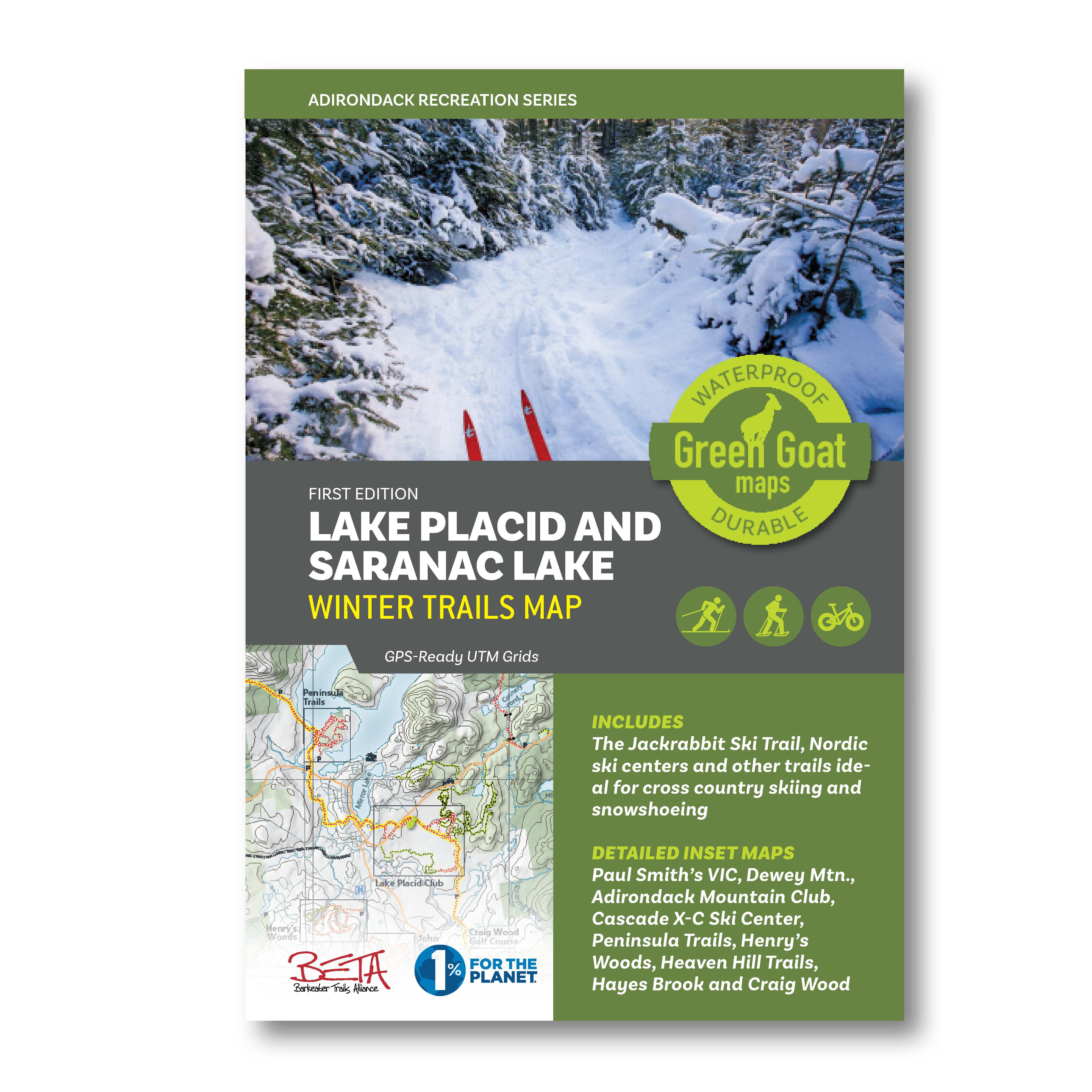
One example of a Green Goat map is the region’s “go-to” map for winter recreation – The Lake Placid and Saranac Lake Winter Trails Map  – which offers all of the area cross country ski, snowshoe and fat bike trails in one document.  The map highlights the Jackrabbit Ski Trail and covers ski trails from Paul Smiths to Wilmington including the popular Hayes Brook Truck Trail, Deer Pond Trails, Moose Pond Trail, Brewster Peninsula Trails, Henry’s Woods, Heaven Hill and more.  The map also includes commercial ski centers, including the Paul Smith’s College VIC, Dewey Mountain Recreation Center, Cascade X-C Ski Center and Mt. Van Hoevenberg.  For the Winter Trails Map, Adirondack Research also added trails on private and municipal land with permissions well as adding gates and parking areas which were mapped from ground research. The top banner on each map inset also shows info about what activities people can do on each individual trail network

Additionally, Green Goat gives 1% back on the sale of its maps to nonprofits through 1% for the Planet.

For more  information on this and similar Green Goat Maps products, visit this page.

Mapping Broadband Infrastructure for Essex County

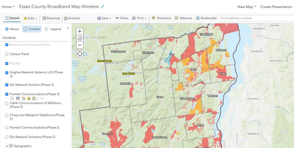
A current project Adirondack Research is working on is with Essex County (as well as four other counties) and local community leaders towards designing and implementing web mapping  visualization tools which will help support and guide expanded broadband installation across the County.   These easy-to-use geospatial tools are intended to be used by local officials in multiple governments to pinpoint gaps in infrastructure coverage. Other aspects of the project include mapping the boundaries of current broadband contracts with providers across the County, checking and verifying property addresses, and performing quality assurance on plan of record build-outs.

Broadband is only available is specific areas of Essex County. Mapping at the street level by Adirondack Research will enable government officials to work with broadband providers to expand coverage.

Contact:

Ezra Schwartzberg, PhD
Adirondack Research
73 Church St
Saranac Lake, NY 12983
www.akdres.org

Green Map 2020: Evolving with Technology and Staying Community Focused

For nearly 30 years, Green Map has been an anchor in the Metro NYC nonprofit mapping community.  Led by its original founder, Wendy Brawer, Green Map’s portfolio of work and advocacy in locally-led mapping and sustainability efforts is quite impressive.  Since the launch of the Green Map System by Wendy Brawer in 1995 and publication of the original Green Map of NYC through her eco-design company, the program’s engagement tools and mapping resources have been adapted by locally-led projects in 65 countries.   Many joined the Green Map network when Greenhouse – their first content-managed website – was activated in 2007.   The site grew to become a rich resource highlighting community developed mapping work in all parts of the world.

While “green” mapping was one of its early defining products and focus,  the organization has expanded its services to include interactive web mapping, education, multimedia, event coordination, workshops, tours, planning and consulting, and creating software development tools.


Community Engagement Maps and Tools

Green Map’s award-winning icons, tools, platform(s) and tutorials help create engaging and visually powerful mapping content used as guides for local nature, culture, community living, social justice and resources for sustainable living. In addition to providing tools and tutorials on making maps, Green Map promotes their mapping efforts as part of Project Stories.  Project Stories are locally written and use tags to categorize the story type, theme, and purpose. Users can  discover how Green Map projects were created, people and organizations involved and about the project’s impact on their community.   Green Map projects are tagged and can be searched as part of the following 11 categories:

Besides its own mapping platform (with version 2 of the Open Green Map now in beta), the program also offers suggestions and tutorials on how to promote the use of the Green Map icons in other interactive mapping platforms such as ArcGIS Online (Story Maps), CARTO, Google Maps, Google Earth, and the Map of Tomorrow.

Continue reading

COVID Era Geospatial Applications to Support Empire State Communities

Here in southeastern New York State, it’s amazing how fast the COVID wave came and went. At first, mid-March to mid-May seemed like an eternity, but now, not so much.  I likened the preparation for COVID to preparing for Super Storm Sandy.  Albeit phenomenally different, the buildup and the anxiety of waiting for it to show up.  Peering out the windows to see the outcome of a completely different kind of damage and suffering  altogether.  Physical and psychological.  Now July, it seems and feels like we can see the first wave of the pandemic in the rear view mirror.  But then as we refocus on the road in front of us, we know there are speed bumps ahead of us.  Not if, but when.

There were a plethora of interesting and meaningful geospatial viewers created across the state during the mid-March to mid-May time frame.  Most included highlighting COVID case numbers by larger units of geography (municipal or zip code boundaries),  generalized heat or pattern maps, impacts to businesses and institutions, as well as  information on hotlines and sources of assistance.  However, its pretty well documented the geospatial community across the state has struggled with being part of providing detailed spatial analysis or mapping support functions at the address level.   Or for that matter, even being asked to participate in this regard.

Personal health related data is uber protected with its use regulated and governed by the Health Insurance Portability and Accountability Act (HIPPA).  HIPPA  regulations reign supreme and contributed to a lesser involvement of GIS analysts in  providing geospatial content, metrics and analytics during the pandemic.  There is also the unspoken reluctance on the part of the public health community to release data sets  which might be difficult to understand or easily misinterpreted by the general public.  Department of Health  professionals often cautious to release data – particularly in new instances such as the COVID pandemic – and leaving analysis/interpretation  to internal professional staff only.  Ultimately though,  releasing some flavor of the data but in a more generalized context.

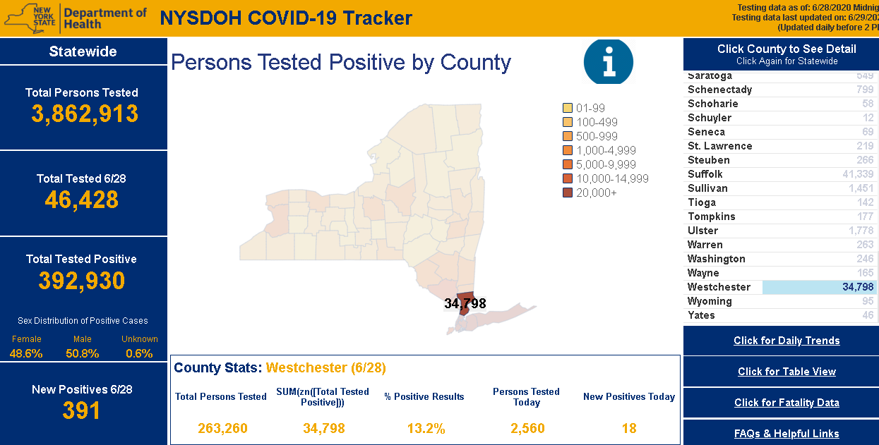
NYS Department of Health (DOH)  COVID-19 reporting has improved dramatically since the pandemic appeared in March.  Though while numbers  are made available only on a county basis, users can access and visualize the data in a variety of ways.  Reporting and posting of the data has become much more timely.  DOH is also now publishing a regional “Early Warning Monitoring Dashboard“.

Continue reading

Google Earth in the Classrooms

Chromebooks, Google Classroom and Google Earth Together Provide a Framework for Teaching Geography and many other subjects in K-12

I actually started drafting an article on Google Earth in the classroom last fall but since then it’s been one thing or another pushing things to the back burner.  Mostly work priorities but then COVID-19 sent everything sideways.  Seemingly pointing us all in a new and uncharted direction.  A new and greater reliance on the internet as many of us found ourselves working remotely.

The remote work force in many of our extended families includes teachers of whom I now have even greater respect after watching what is involved in teaching remotely and online.  The lesson plans, prep work, surgically attached to the computer, and the seemingly endless hours of the encompassing interaction with students – and parents – well beyond the normal eight-hour work day.

In a roundabout way watching this teaching workflow unfold during the COVID lockdown brought me back to the Google Earth article.  Google’s presence in the classroom is ubiquitous built around Google Classroom which I can only imagine will grow immensely as remote K-12 education expands in the future.  Wrapped in with kabillons of lesson plans, templates, covering every education topic, discussion groups, forums, and blogs from around the world – everything built on top of Google technology.  Easily delivered and made available to the masses at all levels of the educational spectrum with the uber cheap and incredibly functional Google Chomebook.  (btw – using one as I type).   And easily accessible within this framework – and bringing me back to the beginning of this article – is the Google Earth product for use in the classroom.  It’s an incredible product to augment K-12 classroom teaching and not just for geography.

Continue reading